12:30 PM | **The latest on the developing major coastal storm**
Paul Dorian
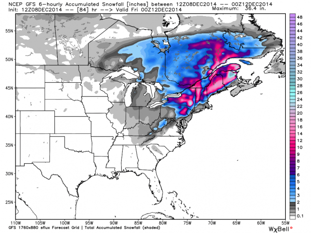 [12Z GFS "total snowfall" forecast map for the entire upcoming event]
Discussion
Overview A major storm will ride slowly up the coast over the next few days and it will bring nasty weather to much of the Northeast US ranging from heavy rain and strong winds in coastal regions to significant, accumulating heavy, wet snow in higher elevation inland locations. A dome of strong high pressure extending from the Northern Plains to eastern Canada will inhibit this developing coastal storm from moving northward and this will lead to a prolonged period of heavy precipitation throughout much of the Northeast US. In fact, in somewhat the same manner as Tropical Storm Agnes in June 1972, this storm is likely to stall out or take a loop on Tuesday night after it reaches the latitude of Long Island or southern New England as its northward progress will be stymied by stubborn blocking high pressure.
Today An area of "ocean-effect" light precipitation has continued to move inland from the Atlantic in the past couple of hours thanks to persistent NE winds on the eastern side of strong high pressure situated to our north. As a result, don't be surprised to see a little snow, sleet or rain during the next few hours - well ahead of any direct effects from the still-developing coastal storm. “Ocean-effect” snow is very similar to the more well-known “lake-effect” snow phenomenon that typically occurs over the Great Lakes when low-level winds pick up moisture over a large body of water and deposit it just inland.
Tonight and Tomorrow The developing coastal storm will produce steadier and heavier precipitation beginning later this evening in the DC area, near midnight across SE PA, and then late tonight in the NYC metro region. At the onset of the main precipitation event tonight, there can be some snow, sleet and/or freezing rain in suburban locations N and W of the big cities and slick spots can quickly form with small accumulations. The air mass in place is quite cold and dry and will only grudgingly retreat in the overnight hours as it is anchored by strong high pressure - always a key player in any snow event in the Northeast US. By tomorrow, however, as high pressure finally retreats from northern New England, the bulk of the precipitation should fall as plain rain, heavy at times, in the I-95 corridor region from DC-to-Philly-to-NYC with 1-3 inches likely by tomorrow night (the lower amounts to the southwest and the higher amounts to the northeast). Coastal sections from New Jersey to southern New England will experience wind gusts of 50mph or more during the height of the storm on Tuesday and Tuesday night. In addition, coastal flooding will be a real concern at times of high tide in those areas. Meanwhile, the greatest threat for heavy accumulating snow will extend from higher terrain locations of upstate Pennsylvania to interior sections of northern New England.
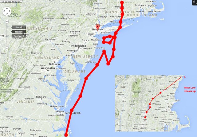 [12Z Euro storm track with the "loop"]
Tuesday night into Thursday Colder air will tend to wrap around the storm once it stalls out (and perhaps takes a loop, middle) in southern New England later tomorrow night/early Wednesday. This "wrap-around" colder air will increase the chances for steady snow or snow showers in the I-95 corridor region from DC-to-Philly-to-NYC during this “back end of the storm” phase from tomorrow night into Thursday. It is certainly within the realm of possibility that snow accumulations occur with slick spots on the roadways during this "back end" phase of the storm; especially, in suburban locations to the N and W of the I-95 corridor region between Philly and NYC. The atmosphere will remain unstable in the Northeast US as late as Thursday afternoon in this long-duration event with an impressive upper-level low spinning overhead (GFS 500 mb forecast map shown below for Thursday morning). This instability in the atmosphere will lead to "dynamic" snow shower activity on Wednesday and Thursday in the I-95 corridor and a few heavier snow squalls are possible at times. One final note, the 12Z GFS computer forecast model has caught up with other models and is now generating a strong coastal storm. The 12Z GFS “total snow accumulation” forecast map (top) for this entire upcoming event depicts the greatest amounts across interior locations of the Northeast US.
Stay tuned, this storm is certainly not set in stone yet.
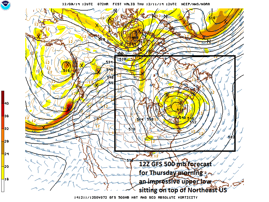 [12Z GFS 500 mb forecast map for Thursday morning]
Video
httpv://youtu.be/EPlzQ9515O0