
1:15 PM | *Incredible cold in Asia anchored by a monster high; Great Lakes intense snow event; tropical update*
Paul Dorian

Today's temperature anomalies across Asia with an extensive area of more than 50 degrees (F) below normal; map courtesy Weather Bell Analytics (Dr. Ryan Maue), NOAA/EMC
Overview
A potpourri of weather to talk about in today's posting. Earlier this week, I posted about the incredible cold coming to Asia and indeed it has arrived with temperatures of more than 50 degrees (F) below normal in an extensive area. The snow pack is deep, the cold air is dense, and it is now resulting in tremendous high pressure that is forecasted to reach as high as 31.47 inches (1066 millibars) later this weekend. This colder-than-normal pattern has persisted for weeks in that part of the world while we have enjoyed warmer-than-normal conditions here in North America – that is about to change.

12Z GFS forecast map of Asia for Sunday, November 20 with tremendous high pressure in circled region; map courtesy tropicaltidbits.com, NOAA/EMC
Short-term: Snowstorm, Arctic blast, and the Great Lakes snow machine
The first major snowstorm of the season is pushing through the Northern US today and producing accumulating snow from Nebraska to Minnesota with more than a foot likely in some spots. The low pressure system responsible for the snow will whip an Arctic front through the Mid-Atlantic region on Saturday night and its passage will result in a much colder Sunday and Monday with very windy conditions (gusts past 40 mph), and possible snow shower activity all the way to the coast. As the Arctic air flows over the still relatively warm (and well above normal) waters of the Great Lakes, there is likely to be the formation of heavy snow bands and even thundersnows this weekend that will flat out dump heavy snow on areas just downstream of the water; especially, in higher elevation locations. Some snow showers will likely make it east of the mountains and all the into the immediate I-95 corridor later in the weekend. Winds should gust past 40 mph on Sunday and the strong NW winds will continue for much of Monday as well in the entire I-95 corridor.

Buoy-measured water temperatures are well above normal for this time of year in southern Lake Michigan and this warmth combined with Arctic cold will help to produce tremendous Great Lakes snows this weekend
Longer-term: December will be a far cry from last year
In the longer-term, all signs point to a far different month of December compared to what we experienced last year (e.g., PHL +13.7 degrees). When snowpack climbs to well above normal levels across the Northern Hemisphere early in the winter season (now the 2nd highest ever) and widespread sustained cold builds up across Asia and Europe, warning signals are set off around here that the upcoming winter season in the Mid-Atlantic region could feature a pattern change to colder-than-normal. Indeed, one of the factors in our colder-than-normal winter outlook for the Mid-Atlantic region had to do with the high snow pack across Siberia that began to form during the month of October.

Snowpack across the entire Northern Hemisphere is at the second highest level ever measured for this time of year
One index that meteorologists use to track pressure patterns across the northern latitudes in called the Arctic Oscillation and when it turns negative for a sustained period of time there are increased chances for sustained cold air outbreaks into the eastern US. In fact, the latest forecast for the AO index suggests a big drop into negative territory over the next couple of weeks. As a result, it appears that we’ll begin to experience more frequent cold air outbreaks over the next couple of weeks – beginning with this weekend’s Arctic blast – and then the month of December will likely be colder-than-normal with accumulating snow chances.
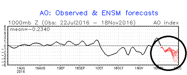
Arctic Oscillation (AO) index with current and past readings in black and forecasted values in red; courtesy NOAA
Tropics
One final note –tropical activity in the Atlantic Basin is not quite over yet. There is an area of showers and thunderstorms tucked in the southwestern part of the Caribbean Sea and it very well could intensify next week. In fact, there is an outside chance that this system intensifies into tropical storm or even hurricane status during Thanksgiving week. While the timing of this is rather unusual, it is not unprecedented. There was a hurricane (Martha) that developed during late November of what was an active year in the tropics, 1969, and it eventually made landfall in the country of Panama – the only known hurricane to have made landfall there.
Meteorologist Paul Dorian
Vencore, Inc.