
12:20 PM | *Coastal storm to bring soaking rain to DC, Philly and NYC*
Paul Dorian
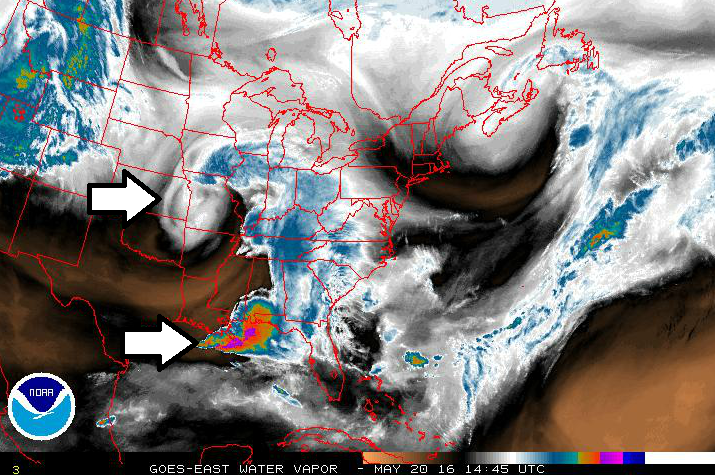
GOES-East water vapor image shows the location of an important upper-level short wave of energy (top arrow) and deep moisture associated with thunderstorms (bottom arrow); courtesy NOAA
Overview
Expansive high pressure is producing a nice end to the work week in the Mid-Atlantic region with plenty of sunshine and warm conditions, but circumstances are about to change quite dramatically. Ingredients are coming together for a significant coastal storm to develop near the Mid-Atlantic coastline during the next 12-24 hours and it is quite likely to produce a soaking rainfall for Philly, DC and New York City as we begin the weekend.

12Z GFS forecast map at surface-level for early Saturday afternoon showing coastal low pressure; map courtesy tropicaltidbits.com, NOAA
Details
The combination of copious amounts of moisture in the southern US, a vigorous upper-level short wave moving eastward from the central US, and a developing upper-level trough of low pressure over the eastern US will lead to the formation of a strong storm on Saturday along the Mid-Atlantic coastline. The latest GOES-East water vapor image shows a bright swirl of moisture over Missouri (top arrow) which indicates the current location of the important upper-level short wave of energy and there is a “colorful” region seen in the northern Gulf of Mexico and this highlights the area of deep moisture in the atmosphere associated with thunderstorms which will feed into the unfolding coastal storm scenario. Rain is likely to arrive in the DC metro region by daybreak on Saturday and it could actually be coming down quite hard a short time later. In Philly, the rain is likely to arrive by the latter part of the morning and then it should reach the NYC metro region during the mid-day hours. The rain will continue in all areas through the rest of the day and well into the night and a stiff northeast wind will keep temperatures well below normal with a struggle to push past the 60 degree mark for highs in many locations. Some parts of the Mid-Atlantic region could receive in excess of two inches of rainfall by the time this coastal storm pulls away later Sunday; especially, in those areas south of the PA/MD border from DC to the Delmarva Peninsula to southern New Jersey.

12Z GFS forecast map at 500 mb for early Saturday night with an "omega-shaped" flow in the upper atmosphere (as highlighted by the red line); map courtesy NOAA
Given the developing “omega-like” blocking pattern in the upper part of the atmosphere with deep troughs of low pressure along both coasts and high pressure ridging in the middle, do not expect it to clear quickly on Sunday. In fact, clouds should dominate the skies on Sunday and lingering showers are quite likely throughout the Mid-Atlantic region. Another disturbance could spark a shower or thundershower on Monday, but there should be plenty of rain-free time as well as we begin the new work week. By the middle of next week, temperatures should (finally) be able to reach the 80 degree mark for highs in the DC-to-Philly-to-NYC corridor and that warmth should stick around.
Meteorologist Paul Dorian
Vencore, Inc.