
12:50 PM | **Severe weather threat in the Mid-Atlantic late Sunday…tropical storm threat continues for Florida**
Paul Dorian

00Z GFS forecast map for early Sunday evening with 500 mb "negatively" tilted upper-level short wave; map courtesy NOAA, tropicaltidbits.com
Overview
It looks like it’ll be quite an active period in the Mid-Atlantic region as we close out the weekend with the threat for heavy rainfall and severe weather including possible supercell thunderstorm development and tornado activity. At nearly the same time, Florida is likely going to have to brace for a potential tropical storm which could generate flooding rainfall in that part of the country by early next week. While Florida is quite a distance away from the Mid-Atlantic region, there may actually be an important connection between the potential tropical storm in the Gulf of Mexico and the severe weather threat around here.

Surface-to-500 mb bulk wind shear as forecasted by 06Z GFS for early Sunday evening; map courtesy NOAA, twisterdata.com
Mid-Atlantic severe weather threat late Sunday
The ingredients are coming together for some heavy rainfall on Sunday in the Mid-Atlantic region as well as severe thunderstorm activity during the late afternoon and evening hours (4-9PM). The severe weather threat later Sunday will include hail, damaging wind gusts, and possibly even a few tornadoes in the Mid-Atlantic region associated with supercell thunderstorms. The ingredients for potential severe weather include an impressive "negatively" tilted upper-level short wave which will be enhancing upward motion in the atmosphere from DC-to-Philly-to-New York City during the afternoon and evening hours on Sunday. The forecast map for early Sunday evening from last night’s 00Z GFS model run shows the location of the "negatively" tilted upper-level short wave (indicated by dashed line) at the most unstable time of the day.
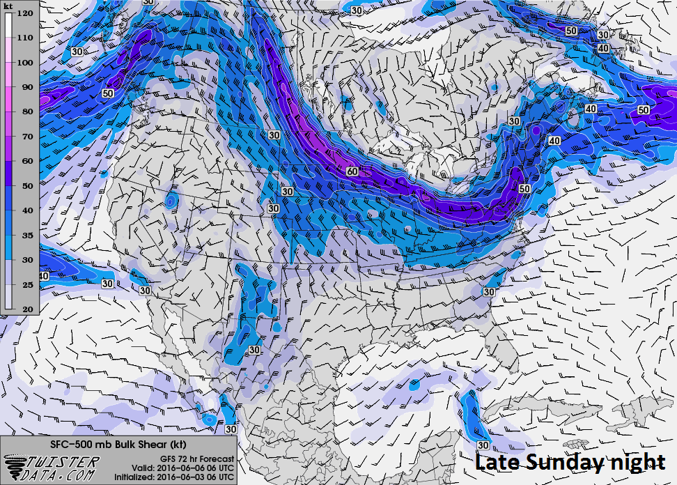
Surface-to-500 mb bulk wind shear as forecasted by 06Z GFS for late Sunday evening; map courtesy NOAA, twisterdata.com
In addition, signs point to increasingly high levels of surface-to-500 millibars (~5 kilometers) bulk wind shear late Sunday which raises the possibility of supercell thunderstorm formation and potential tornado activity. The bulk wind shear will strengthen later Sunday to rather dangerous levels of 40+ knots by early Sunday night and then 50+ knots by later Sunday night as the aforementioned upper-level wave pushes through. The bulk wind shear denotes changes in wind speed throughout the layer between the surface level and ~5 kilometers up in the atmosphere. Thunderstorms tend to become more organized and persistent as vertical shear increases. Supercells are commonly associated with vertical shear values of 35-40 knots and higher in this part of the atmosphere and those thresholds are likely to be achieved by late Sunday. One final ingredient that will be available for both the threat of severe weather and heavy rainfall is "atmospheric moisture" which will be quite plentiful as suggested by the "precipitable water" forecast for Sunday evening (below) from today's European model run. In fact, this forecast by the Euro indicates there will be plenty of moisture available all along the east coast extending northward to New England from the potential tropical storm in the Gulf of Mexico.

Latest colorized infrared image of Caribbean Sea/Gulf of Mexico showing widespread thunderstorm activity (circled area). This disturbance may become Tropical Storm "Colin" by early next week and potentially pound Florida with heavy rainfall; image courtesy University of Wisconsin/CIMSS
Tropical storm threat continues for Florida
Signs continue to point to the formation of a tropical storm in the eastern Gulf of Mexico late in the weekend and this system would likely then cut a general southwest-to-northeast path likely across the central or northern part of the state of Florida. If “Colin” does form and take this path, it could produce several inches of rain over a good portion of Florida in the Monday/Tuesday time period. The latest colorized infrared satellite image (above) shows a large area of thunderstorms in the western Caribbean Sea (circled region) and this disturbance will spill out over the Gulf of Mexico by the latter stages of the weekend. As the tropical system turns towards Florida, heavy rainfall will likely break out across much of the state and several inches could accumulate by the time Tuesday morning rolls around as "precipitable water" amounts in the atmosphere will be quite high supporting excessive rainfall amounts (forecast map below for Sunday evening).

Precipitable water amounts for Sunday evening as depicted by today's European model forecast; map courtesy Dr. Ryan Maue, Weather Bell Analytics
Once this tropical system crosses over Florida early next week, it is then likely to continue on a northeasterly track that takes it out over the open waters of the western Atlantic Ocean - rather than taking a turn up along the eastern seaboard and towards the Mid-Atlantic region. Deep upper-level low pressure will be setting up early next week over the Northeast US and its steering currents would likely prevent any movement of “Colin” into the Mid-Atlantic coastal region.
Meteorologist Paul Dorian
Vencore, Inc.