
3:25 PM | *Tropical update in the active Atlantic Basin*
Paul Dorian
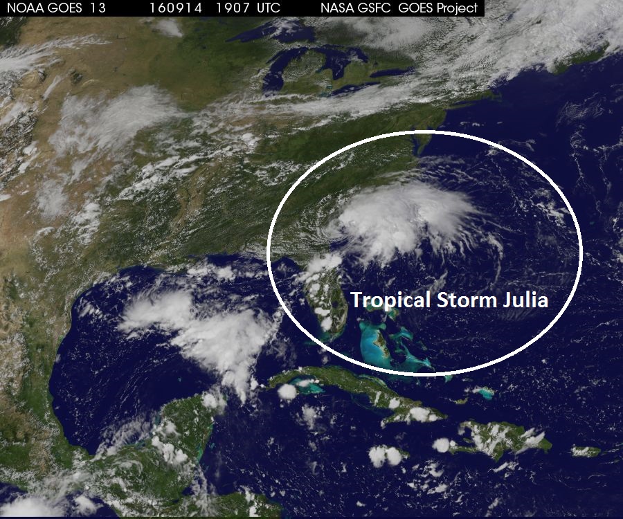
Satellite image of Tropical Storm Julia; courtesy NOAA/NASA
Overview
We have now entered the climatological peak of the Atlantic Basin tropical season and there are three different systems to monitor over the next several days. To begin, an impressive tropical wave has now achieved “tropical depression” status in the eastern Atlantic Ocean and all indications are that it will strengthen to tropical storm status in the next day or two. In the central Atlantic, Tropical Storm Ian is moving northward and it appears to be no threat to the US mainland. Meanwhile, just offshore of the George/South Carolina border region, Tropical Storm Julia is moving very slowly and this poses a big problem in terms of rainfall for coastal Georgia and the Carolinas during the next couple of days. There is a chance that some of the moisture associated with “Julia” interacts with an eastward moving frontal system and enhances rainfall around here late in the weekend or early next week.

Visible image of Tropical Storm Ian and Tropical Depression 12; courtesy Penn State eWall, Naval Research Lab
Tropical Storm Ian
TS Ian is the strongest of all three areas of interest; however, of the least concern. TS Ian has max sustained winds of 50 mph and is moving north at 20 mph and this northward motion is likely to continue during the next day or two. After that, TS Ian is expected to turn to the northeast and speed up – all likely eliminating its chances of having any impact on US soil.
Tropical Depression 12
TD 12 has formed near the Cape Verde Islands in the eastern Atlantic Ocean and currently has max sustained winds of 35 mph. The present movement of TD 12 is WNW at 14 mph and it is likely to attain tropical storm status within the next 24 hours or so. The latest visible satellite image shows a well-defined circulation center and some strengthening has occurred in the past 24 hours and is likely to continue over the next 24 hours. TD 12 is likely to move WNW in the next few days as it remains under the influence of a ridge of high pressure in the low and middle parts of the atmosphere. This system may very well have to be dealt with in about a week to ten days in the Southeast US/Caribbean Sea/Gulf of Mexico region.
Tropical Storm Julia
TS Julia is perhaps the most interesting of the three tropical systems as it formed in an unusual fashion primarily over land (NE Florida) during the past 24 hours or so. Tropical storm formation can take place over land if the upper-level dynamics favor such intensification, but it is not all that common. One of the most recent storms to form in a similar fashion was Tropical Storm Beryl in 1988 which attained tropical storm status while over the southeastern part of Louisiana.
One of the reasons Julia has to be closely monitored is the fact that it will move very little in the next 48 hours or so and this will allow for the possibility of intensification as it meanders near or over the warm waters of the western Atlantic. In addition, another important reason to monitor Julia is the possibility that some of its moisture gets wrapped into an eastward moving frontal system that arrives in the eastern US late this upcoming weekend. There can be up to a foot of rain over the next couple of days in coastal sections of Georgia and the Carolinas.
Stay tuned.
Meteorologist Paul Dorian
Vencore, Inc.