11:25 AM | **Major pattern change to cold begins at mid-week in the I-95 corridor…assures a far different December compared to last five years**
Paul Dorian

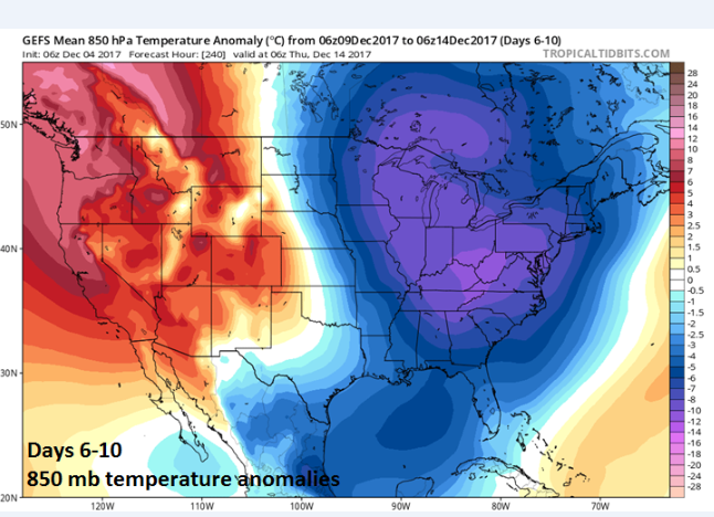
06Z GEFS forecasts map of 850 mb temperature anomalies for days 6-10 (left) and days 11-15 (right) with sustained cold in the Midwest, Mid-Atlantic and Northeast US; maps courtesy tropicaltidbits.com, NOAA/EMC
Overview
A major pattern change is going to begin on Wednesday in the Mid-Atlantic region and it will result in a period of sustained colder-than-normal temperatures that will assure a much different December compared to the last five. This pattern change to cold will also include increasing chances for snow – perhaps as early as late this week or during the upcoming weekend – as an active upper-level trough forms in the eastern US associated with the initial cold blast.
Discussion
This December will be a far cry from the last five years in the I-95 corridor which were unanimously above-normal in Philly, Washington, D.C. (DCA) and New York City (Central Park):

A pattern-changing cold front will usher in an initial blast of cold air for the Mid-Atlantic region at mid-week and this will just be the first shot of many to come during the month of December. This first shot of cold air will head all the way down to the Gulf coast states by the latter part of this week. Ahead of the strong cold front, it’ll turn quite mild on Tuesday with highs at or above 60 degrees in much of the I-95 corridor and showers will develop later in the day. There may even be a period of steadier rain tomorrow night as the front pushes through the region and colder air will become quite noticeable on Wednesday with stiff NW winds.

06Z GEFS forecasts map of 500 mb height anomalies for days 6-10 (left) and days 11-15 (right). The 500 mb height anomaly forecast maps show a persistent upper-level pattern with a deep trough in the central/eastern US, strong ridging along the west coast of Canada and the Pacific Northwest, and strong ridging at high latitudes. ; maps courtesy tropicaltidbits.com, NOAA/EMC
This initial strong cold front will tend to stall out along the Southeast US coastline later this week and a couple of waves of energy in the upper part of the atmosphere will swing around an intensifying upper-level trough. As a result, low pressure is going to try to form along the east coast later in the week, but it may stay just to the east of the immediate I-95 corridor.

12Z operational GFS forecast map of 500 mb pattern as of Saturday, December 9th featuring strong energy dropping southeastward across the Great Lakes; map courtesy tropicaltidbits.com, NOAA/EMC
If this late week threat doesn’t materialize in the immediate I-95 corridor then there may be another chance for some snow this weekend. At that time, the deep upper-level low associated with this initial shot of cold air will move close by and the result is likely to be some snow or snow shower activity in the I-95 corridor as low pressure tries to form near the east coast. A second shot of even colder air is likely to arrive next week in the Mid-Atlantic region and this air mass could be amazingly cold for this time of year.

12Z GFS forecast map for late Saturday night with snow showers in parts of the Mid-Atlantic region (in blue); map courtesy tropicaltidbits.com, NOAA/EMC
Stay tuned…this December is going to be quite different compared to the previous five years and the overall pattern is full of potential for snow.
Meteorologist Paul Dorian
Vencore, Inc.
vencoreweather.com
Morning video discussion on the upcoming pattern change and potential for snow: