
1:30 PM | **Big time cold on the way for the Mid-Atlantic region…prospects for snow as well next several days**
Paul Dorian

This is the look of sustained cold from the 12Z operational GFS i.e., cold air mass after cold air mass for an extended period of time; maps courtesy tropicaltidbits.com, NOAA/EMC
Overview
A major pattern change to cold has now begun in the Mid-Atlantic region with the passage of a strong cold frontal system and it is going to get worse before it gets better. This initial shot of cold air is not brutal, not record-breaking by any means, but it is just the front end of a pattern change that will bring even colder air here for the late week and weekend, and then some big time cold is destined to flood the Mid-Atlantic region by the middle of next week. In fact, it is possible that DC, Philly and NYC will struggle to reach the freezing mark for highs by the middle of next week. In addition to the intensifying cold over the next several days, there are some prospects for snow in the I-95 corridor. The first chance of snow will come from later Friday into Saturday, the second shot comes Saturday night into early Sunday, and then the third threat comes in the Tuesday/early Wednesday time frame associated with the mid-week significant cold air outbreak.
Discussion
Temperatures are holding nearly steady in the low-to-mid 40's at mid-day in the I-95 corridor – much cooler than yesterday – and highs are likely to be confined to the same general area on Thursday. By Friday and also for the weekend, somewhat colder air will make it into the region and highs are likely to hold in the 30’s for highs in much of the Mid-Atlantic on all three days. By the time the middle of next week arrives, there is likely to be another cold air outbreak and the core of this mid-week Arctic blast may be heading right towards the Mid-Atlantic region. This type of path for that cold air mass could keep high temperatures in the I-95 corridor confined to freezing or below by the middle of the week.
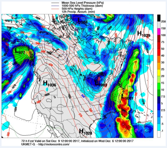
12Z UKMET forecast map for Saturday morning with precipitation well inland from a coastal low pressure system over the Southeast US coastline...other computer forecast models (e.g., Euro, GFS) keep the precipitation to the east of Route I-95
In terms of snow potential, an intensifying trough in the upper atmosphere will feature a wave of energy that will rotate through at the end of the week. This system is likely to help form a low pressure system near the Southeast US coastline and moisture will ride up along the east coast. Some moisture may back far enough to the west to produce snow in the immediate I-95 corridor later Friday into Saturday and places to the east of Route 95 (e.g., Delmarva, southern New Jersey, southeastern Virginia) could very well see accumulating snow. Most computer models are currently keeping the moisture associated with this late week system to the east of Route I-95; however, the potential still exists for this to expand farther to the north and west as event time approaches. In fact, the 12Z UKMET computer forecast map for Saturday shows just that – precipitation backing west into the I-95 corridor - from a low pressure system near the Southeast US coastline.
Following that initial threat, there is a chance that an upper-level low will generate snow showers in parts of the Mid-Atlantic region late Saturday night into early Sunday – perhaps even a few heavier snow squalls. This upper-level system is quite energetic and the result could be interesting (i.e., volatile) as reinforcing cold air pours into the Mid-Atlantic - Sunday promises to be quite a cold day with stiff NW winds.
Finally, as the mid-week significant cold air outbreak approaches the Mid-Atlantic region, there are signs that upper-level energy will dive to the southeast across the Great Lakes and towards the Southeast US. If this system can “dig” far enough to the southeast, there may be a coastal storm to deal with in the Northeast US as that next cold air mass pours into the Mid-Atlantic region.
Stay tuned.
Meteorologist Paul Dorian
Vencore, Inc.
vencoreweather.com
Extended video discussion on the upcoming prospects for snow: