1:10 PM | *Snow threat continues here with storm number one (late Thursday night/early Friday)…second storm takes a southern route this weekend…third system possible early next week*
Paul Dorian

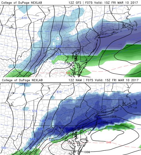
12z model runs (GFS top, NAM bottom) depict snow (blue) in much of the Mid-Atlantic region at 10am on Friday (3/10/17); maps courtesy College of DuPage, NOAA/EMC
Overview
Winter is not quite over yet and there are three threats to monitor in the Mid-Atlantic region for the period from Thursday night through early next week The first wave of low pressure is likely to arrive in the Mid-Atlantic region late Thursday night with only marginally cold air in place, but it’ll actually turn colder during this event. As a result, this late week system is liable to result in a “rain changing to snow” scenario and some grassy snow accumulations are possible in the northern and western suburbs of DC, Philly and NYC. A second and stronger system will take a southern route this weekend and it’ll arrive in the eastern US in the Saturday night/Sunday time frame. This system should have plenty of cold air to work with in the I-95 corridor and snow would likely be the dominant precipitation type; however, it may be suppressed so far to the south that much of the I-95 corridor may escape with little, if any, snowfall. Finally, there is a chance that a third system arrives in the Mid-Atlantic region in the late Monday/Tuesday time period of next week and there should be enough cold air in place for the possibility of snow.

12Z GFS total snowfall forecast map for the Thursday night/Friday event; map courtesy tropicaltidbits.com, NOAA/EMC
Details
A cold front passes through the region by early tomorrow, but it will remain quite mild behind the front not only for the rest of Wednesday, but for Thursday as well. A secondary (Arctic) cold front will arrive on Thursday night at the same time low pressure develops in the Mid-Atlantic region. Precipitation should break out in the form of rain in most of the Mid-Atlantic region on Thursday night, but as colder air pushes in from the north, a changeover to sleet and then snow is likely to occur (from north-to-south). In fact, by early Friday morning, it could be snowing all the way from the northern and western suburbs of DC to the Philly and NYC metro regions and there can even be a period of some decent snow. The latest computer forecast models (GFS, NAM) show primarily snow falling at mid-morning (10am) on Friday morning. Accumulations will likely be limited during this late week event given the initial rainfall that is expected; however, a couple of inches of grassy accumulation is not out of the question for the northern and western suburbs of DC, Philly and NYC.
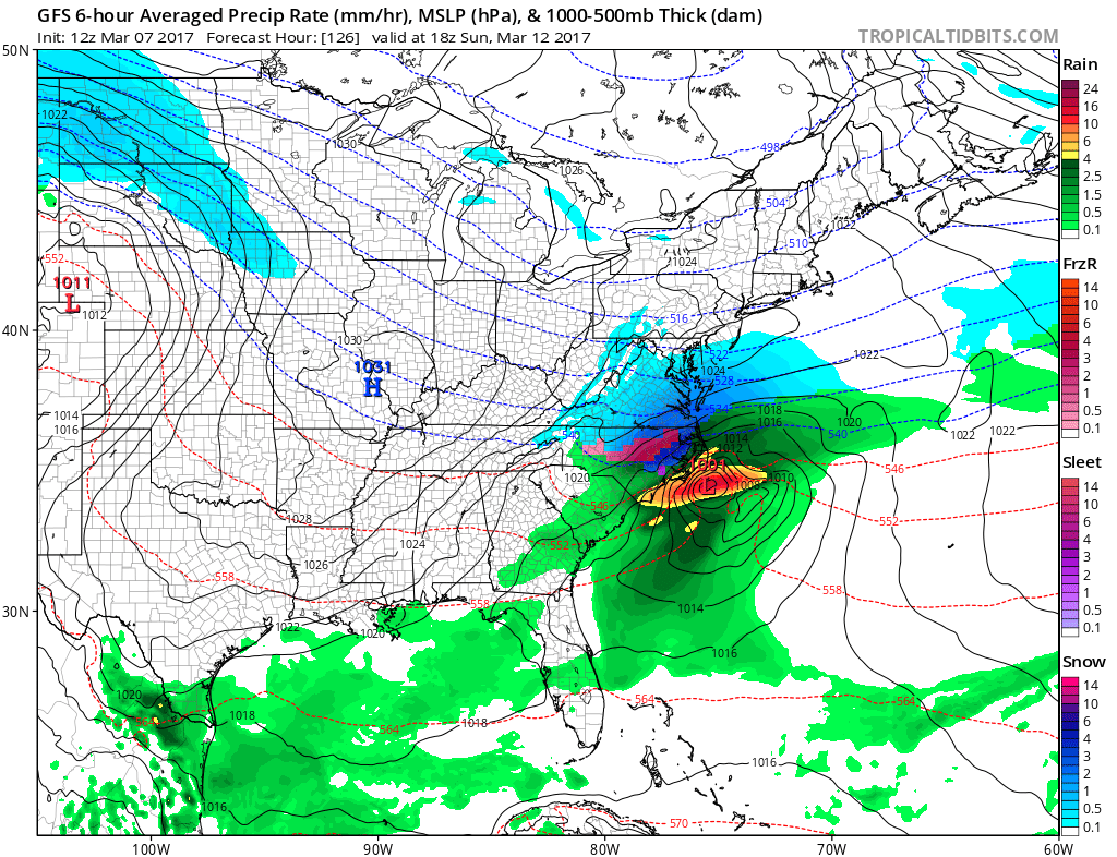
12Z GFS surface forecast map for 1pm on Sunday (3/12/17) depicting a stronger second system that takes a more southern track; map courtesy tropicaltidbits.com, NOAA/EMC
Following the first system, much colder air will pour into the Northeast US for Saturday and it will be a day with well below normal temperatures on the order of 15-20 degrees. As a result of this strong push of cold air into the Northeast US, the next wave of low pressure will be suppressed farther south compared to wave number one. In fact, the weekend system could trek from around Arkansas to the South Carolina coastline by early Sunday limiting the chances for snow as far north as Philly and NYC - and perhaps even in the DC metro region. This system will have plenty of cold air in place so anything that does fall in the Mid-Atlantic region is likely to be in the form of snow. There are still several days to go before this second event and a small change in the timing of the phasing of the expected upper-level energy could make a big difference – even as far north as NYC.
Finally, a third system is likely to head east early next week and this could result in some snow for the Mid-Atlantic region in the Monday/Tuesday time frame.
Stay tuned, all three events are not set in stone. In fact, the final evolution of system number one on Thursday night and Friday will quite likely have an impact on system number two (weekend) which will then likely impact system number three (early next week).
Extended video discussion: