
11:30 AM | **March Madness…accumulating snow on Friday in the I-95 corridor…Arctic blast for the weekend…another storm threat comes Tuesday with big potential**
Paul Dorian

12Z GFS forecast map for 1pm on Friday with snow (in blue) all the way down into the DC metro region; map courtesy tropicaltidbits.com, NOAA/EMC
Overview
The next week or so could actually end up being the worst stretch of winter all season long for parts of the Mid-Atlantic region. An Arctic front will slowly press through the region late tonight and Friday as low pressure rides along the boundary zone likely producing accumulating snow all the way down into the DC metro region. Rain will develop at the onset during the overnight hours in the DC, Philly, NYC corridor, but then as colder air filters in from the north, there will be a changeover to snow from north-to-south. Snow can continue into the mid-day hours on Friday in the I-95 corridor and there can be a few additional snow showers during the afternoon - perhaps even a heavier snow squall. Arctic air will completely overtake the Mid-Atlantic region tomorrow night and punish us throughout the upcoming weekend with temperatures some 15-20 degrees below normal for this time of year. Yet another storm threatens the I-95 corridor in the Monday night/Tuesday time frame and it could intensify rapidly near the coastline with lots of cold air in place – in other words, big potential.

12Z GFS total snowfall forecast map for the Thursday night/Friday storm; map courtesy tropicaltidbits.com, NOAA/EMC
Late tonight/Friday
Low pressure will form along an Arctic frontal boundary zone later tonight and rain is likely to break out in the I-95 corridor after midnight. As colder air pushes in from the north late tonight and Friday, there will be a changeover of rain-to-snow from the north-to-the-south and this changeover should eventually even extend into the DC metro region. Accumulations will primarily take place on non-paved surfaces; however, road conditions could be impacted during bursts of heavier snow on Friday. The accumulation estimates are as follows (and they have been increased slightly from earlier estimates):
DC region: a coating to an inch or so,
Philly region: 1-3 inches,
NYC region: 3-5 inches.
Weekend Arctic blast
By tomorrow night, winds will intensify out of the north/northwest and Arctic air with its origins in the Canadian Arctic will flood into the Northeast US. An example as to just how cold this air mass has been at its source region, Mould Bay, Canada which is located on Prince Patrick Island in the Northwest Territories, set a record low temperature last weekend of minus 66.5 degrees (F) [credit to Washington Post/Capital Weather Gang]. In addition, Fairbanks, Alaska saw its temperature plunge yesterday to minus 39 degrees (F) – this kind of extreme cold is rarely seen there this late in the winter season. High temperatures on Saturday in Philly could struggle to reach the freezing mark at a time of year when normal highs are around 50 degrees.
This forceful plunge of Arctic air into the Northeast US will contribute to a suppressed storm track later in the weekend for a system that may actually end up in the Deep South. This southern route should spare the DC, Philly, NYC corridor from any snowfall during the second half of the weekend, but it’’ll stay very cold for this time of year.
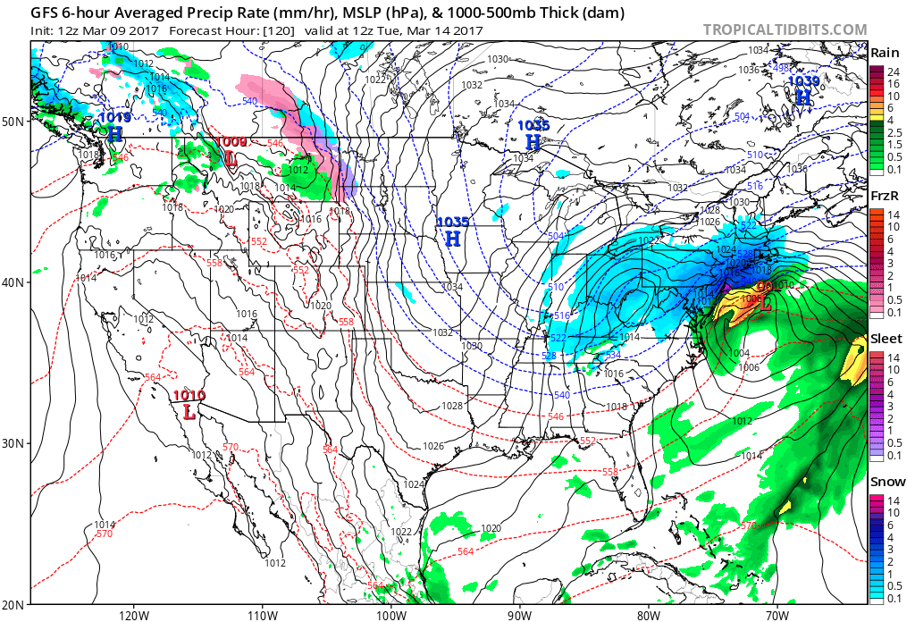
12Z GFS forecast map for Tuesday morning (3/14/17) showing big snow potential; map courtesy tropicaltidbits.com, NOAA/EMC
Late Monday night/Tuesday storm threat
By early next week, vigorous upper-level energy will drop southeastward from central Canada into the northern US and this could ultimately spawn the formation of a rapidly intensifying low pressure system near the Mid-Atlantic coastline by early Tuesday of next week. There will be plenty of cold air in the Northeast US so the possibility of accumulating snow does exist in the late Monday night/Tuesday time frame and given the potential for a deepening upper-level trough, there is big potential with this system. A reinforcing Arctic cold blast will follow this storm and keep it well below normal around here right into the middle of next week.
Stay tuned, this is an active and complicated pattern.
Today’s extended video discussion:
Meteorologist Paul Dorian
Vencore, Inc.
vencoreweather.com