12:30 PM | **Heavy rain and possible strong-to-severe thunderstorms**
Paul Dorian

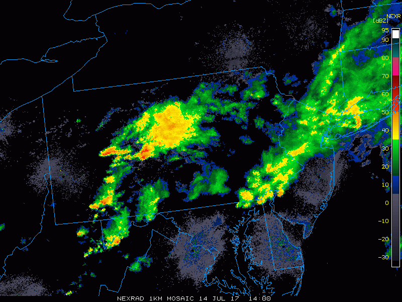
Mid-day radar loop with explosion of thunderstorm cells across West Virginia; courtesy College of DuPage, NOAA
Overview
There are two big weather concerns for the Mid-Atlantic region this afternoon and evening and they revolve around the potential for flash flooding and the possible formation of severe thunderstorms. The greatest chance for flash flooding appears to be in areas near and north of the PA/MD border where copious amounts of rain has already fallen and the greatest chance for severe thunderstorms is likely to take place near and south of the PA/MD border where sunshine has boosted temperatures into the lower 90’s at mid-day in some spots. Two systems will play a role later today in the potential additional heavy rainfall and severe thunderstorm activity in the I-95 corridor. First, a surface cold frontal system is moving slowly southeastward from the Ohio Valley towards the Mid-Atlantic and second, an upper-level wave of energy is pushing eastward across the Great Lakes. The combination of these two systems will generate upward motion in the I-95 corridor during the afternoon and evening hours and the radar will likely explode as a result.

Mid-day visible satellite loop with clouds dominating north of the PA/MD border and sunshine boosting temperatures south of the PA/MD border; courtesy College of DuPage, NOAA/GOES
Flash flooding concerns
Whenever the atmosphere is excessively humid, it can produce some heavy rainfall amounts in a short period of time and that certainly continues to be a threat for much of the Mid-Atlantic region. Dew points at midday are in the upper 70’s in the DC metro region and lower 70’s near Philly - suggestive of very high moisture content in this entrenched tropical-like air mass. In fact, many spots at mid-day have dew points at or above the 80 degree mark which is indicative of an extremely moist atmosphere. As a result, any storm that crosses the I-95 corridor later today can dump a few inches a rain in a short period of time and this will, of course, raise concerns for localized flash flooding; especially, in those spots north of the PA/MD border where grounds are pretty well saturated from earlier heavy rains.

Upper-level wave of energy located over the Great Lakes by early tonight; courtesy tropicaltidbits.com, NOAA/EMC
Severe thunderstorm concerns
Clouds dominate the skies north of the PA/MD border at mid-day and this has held temperatures to the 70’s in places like southeastern Pennsylvania. This cooling effect of the clouds is keeping the boundary layer much more stable in those areas north of the Mason/Dixon Line. Meanwhile, near and south of the PA/MD border, sunshine has boosted temperatures into the lower 90’s in places like the DC metro region and this is destabilizing the atmosphere. The differential surface heating boundary zone could very well act as a focus for thunderstorm development later today roughly near the southern PA border. Given the more unstable atmosphere near and south of the PA/MD border due to the enhanced surface heating, it appears the greatest chance for severe thunderstorm activity later today is likely to be in those hotter areas such as the DC metro region.

Mid-day dew point readings with excessively moist areas at or above 80 degrees; map courtesy crankyweatherguy (twitter)
Radar is currently showing showers and thunderstorms in much of the Mid-Atlantic and the coverage area and intensity should increase substantially during the PM hours as the upward motion increases in the I-95 corridor due to the approach of the surface frontal system and upper-level wave of energy. The area of thunderstorms across West Virginia at mid-day is especially of concern for the DC metro region as the radar is lighting up like a Christmas tree and these cells are heading generally in an eastward fashion.
In addition to torrential downpours, any storm that forms later today can cause damaging wind gusts up to 60 mph, hail and frequent lightning. Wind shear will play an increasing role in this unfolding scenario (surface winds out of the south, upper-level winds out of the west) and this could cause some thunderstorm cells to rotate – hence, an isolated tornado or two is possible and this kind of threat is likely to be focused on the area from near the southern Pennsylvania border-to-southern New Jersey and across the Delmarva Peninsula.
Weak high pressure will build into the region this weekend and the overall weather pattern will improve, but do not expect a cool and refreshing type of air mass. It’ll be quite warm on Saturday with sunshine and highs well up in the 80’s and then thermometers will likely flirt with the 90 degree mark on Sunday afternoon, but rain chances this weekend will be minimal.
Bottom line...stay alert...flash flooding and severe thunderstorms a threat this afternoon and evening in the entire DC-to-Philly-to-NYC corridor.
Meteorologist Paul Dorian
Vencore, Inc.
vencoreweather.com
Morning video discussion: