
5:15 PM Update | *****High impact weather event unfolding with accumulating snow followed by extreme cold and dangerous sub-zero wind chills*****
Paul Dorian

The storm developing an eye is seen in GOES 16 RGB nighttime microphysics imagery.
5:15 PM Update:
A high impact weather event is unfolding for much of the eastern US with accumulating snow to be followed by extreme cold and dangerous sub-zero wind chills. Low pressure is rapidly intensifying at this hour just east of the Georgia/Florida border region in an area of deep convection and numerous lightning strikes in the last couple hours. A coastal front has developed paralleling the coastline in a general south-to-north fashion and this strengthening low pressure system will ride along its boundary zone for the next several hours. Moisture has expanded on radar in recent hours with snow already pushing into southern Virginia. It has been snowing hard in recent hours in places like Charleston, South Carolina.

Lightning strikes have increased in general vicinity of low pressure intensification off the SE US coastline.
Current observations combined with satellite and radar images suggest this storm will indeed have a somewhat bigger impact to inland areas in terms of snowfall with its storm track likely to be somewhat closer to the coast than earlier projections. As a result, snow accumulation amounts are likely to be higher in the DC-to-Philly-to-NYC corridor, but still with the general idea of a more to the east and less to the west. Here are the latest snowfall estimates for the I-95 big cities:
DC: dusting to 2 inches west of the District; 1-3 inches in the District and to points on its east
Philly: 2-4 inches on the west side of Philly; 4-6 inches in Philly and to points on its east
NYC: 5-8 inches with even higher amounts across Long Island
Coastal NJ and Delmarva Peninsula: 9-12 inches
Blizzard conditions are likely with this storm near the coastline all the way from New England-to-New Jersey-to-the Delmarva Peninsula-to-southeastern Virginia.

Expanding area of moisture showing up on radar late today; courtesy NOAA, Mesonet
The snow primarily falls in the period from just after midnight to early afternoon on Thursday in the DC-to-Philly-to-NYC corridor. Extreme cold and strong winds with dangerous sub-zero wind chill values will follow the storm in the Thursday night-to-Saturday night time period. For more information, refer to the 10:45 AM posting below.

12Z NAM surface forecast maps for tomorrow morning (left) and tomorrow evening (right) with powerful and deepening ocean low pressure causing snow (in blue) in the I-95 corridor; maps courtesy NOAA/EMC, tropicaltidbits.com
Overview (10:45 AM)
A high impact weather event is unfolding for much of the eastern US with accumulating snow to be followed by extreme cold and dangerous sub-zero wind chills. A powerful storm over the western Atlantic Ocean will deepen explosively during the next 24-36 hours as it moves generally northward from off the Florida coastline today to just east of Maine by tomorrow night. This storm will develop hurricane-like strength by tomorrow night when its central pressure could bottom out near 28.14 inches (953 millibars) – this is on the same level as category 3 (major) hurricanes. Extremely cold air will pour into the eastern US on the heels of this ocean storm and given its intense pressure gradient, winds will strengthen significantly on Thursday night and Friday. The combination of wind gusts past 40 mph and the extremely cold temperatures will generate dangerous sub-zero wind chill values for an extended period of time from Thursday night to Saturday night. After that, some moderation in temperatures should arrive early next week, but that temporary “warm up” may be accompanied by some wintry precipitation.

12Z NAM forecast map of total snow depth change for upcoming storm (period through Friday night); map courtesy NOAA/EMC, tropicaltidbits.com
The powerful Atlantic Ocean storm
Believe it or not, it is snowing at Tallahassee, Florida at last hour for the first time in 28 years. A low pressure system is now forming off of the east coast of Florida and it’ll become a monster by the time it reaches the area to the east of Maine on Thursday night. Strong upper energy is currently diving southeast into the Gulf of Mexico and low pressure is forming just to the east of Florida in an area experiencing numerous lightning strikes in recent hours. This storm will intensify rapidly as the upper-level energy “phases” together near the east coast and a deepening trough aloft goes negatively-tilted (i.e., trough axis oriented NW-to-SE).
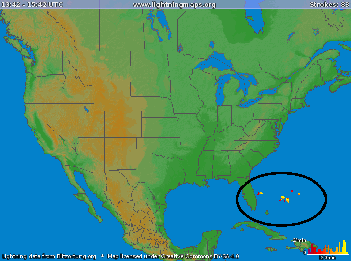
Current lightning strikes to the east of Florida in area where low pressure is now forming; map courtesy lightningmaps.org
Typical for rapidly intensifying ocean storms, there is likely to be a sharp drop off to precipitation amounts on its western edge. Snow is likely to accumulate on the order of a dusting to 2 inches or so in the DC metro region with 2-4 inches in the Philly metro region (the higher amounts in these ranges more likely in eastern areas of the metro regions). Significantly higher amounts of snow are likely across coastal NJ and the Delmarva Peninsula where 6-12 inches are likely. The NYC metro region is likely to receive 3-6 inches of snow with significantly higher amounts just to its east over Long Island and southeastern Connecticut. Much of eastern New England is likely in store for a foot or more of snow to go along with the very strong winds. Downright blizzard conditions are likely during this storm along coastal sections from "New England to New Jersey to the Delmarva Peninsula to southeastern Virginia" and could even extend somewhat to inland locations. Any slight shift to the west in the storm track can increase expected snow amounts in the DC-to-Philly corridor and this is still within the realm of possibility. The timetable for snow around here is from later tonight through tomorrow morning and its biggest travel impact will be on the Thursday morning commute. Snow winds down later tomorrow and the winds pick up in intensity gusting to 40 mph out of the NW by late in the day with blowing and drifting snow likely to develop as the rapidly strengthening storm pulls away to the north off of the New England coastline. Many schools will likely close on Thursday due to the snowfall and slippery road conditions which is quite likely given the very cold ground-level temperatures of recent days and I expect many schools will consider closing on Friday as well due to the expected severe and dangerous cold.

12Z NAM surface temperature forecast maps for Friday morning (left) and Saturday morning (right) with single digit lows in the I-95 corridor; maps courtesy NOAA/EMC, tropicaltidbits.com
The extreme Arctic cold and intense winds to follow
Brutally cold conditions are expected between tomorrow night and Saturday night and more record low temperatures are likely in much of the region. Numerous records have been during the past few mornings in this cold stretch that began before Christmas and will continue until early next week - one of the coldest stretches of weather in a long, long time for much of the nation. The cold wave is especially impressive given its extent in time (2-3 weeks) and space (Rockies to the east coast to the Gulf coast) and is somewhat reminiscent of the very cold month ofJanuary 1977 which was well below-normal in the same general vicinity. In fact, many of the record lows that were set during the past few days broke records that were originally set in January of 1977.

More record or near record lows this morning across the Mid-Atlantic region; map courtesy coolwx.com
Temperatures today ahead of the storm will actually make a run towards the upper 20's, but that will be the high point of the week. Single digits lows are quite likely again on Friday and Saturday mornings and highs will do no better than the low-to-mid teens in many spots on both days. Wind chill values are likely to drop well below zero in the period from Thursday night into late Saturday as gusts past 40 mph are likely following the departure of the powerful Atlantic Ocean storm. A real concern is the threat for scattered power outages in this extended cold period following the snowfall. Any power outages during this extreme cold time period would, of course, have a high impact.
Be prepared for this unfolding high impact weather event and check this NOAA web site for information on winter safety tips.
Meteorologist Paul Dorian
Vencore, Inc.
vencoreweather.com