12:30 PM | *Major storm threat this weekend along the eastern seaboard and a category 5 hurricane in the Pacific Ocean may play a role*
Paul Dorian

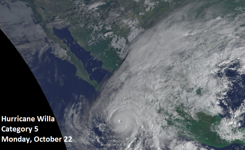
Latest satellite image of Hurricane Willa in the northeastern Pacific Ocean now classified as a category 5; courtesy NOAA
Overview
The month of October has a way of ending on occasion with very powerful storms near the east coast of the US including Hurricane Sandy in 2012 and the “perfect” storm on Halloween Day in 1991. While these two are extreme examples, there continue to be strong signals for a major storm near the east coast this weekend that could actually get a boost of energy and moisture from a category 5 hurricane in the northeastern Pacific Ocean. Heavy rain and strong winds are the main threats in the immediate I-95 corridor region from DC-to-Philly-to-NYC, but snow is on the table from this potential storm in the higher elevation regions from West Virginia to interior New England. This could turn out to be a rather long-lasting storm as well given the expected very large-scale upper-level trough that will set up during the weekend.

Very potent upper-level pattern setting up for the weekend; courtesy NOAA, tropicaltidbits.com
Discussion
The combination of vigorous energy in the upper part of the atmosphere and a ton of moisture from the Gulf of Mexico region is likely to result in a strong storm right near the Mid-Atlantic coastline by the early part of the upcoming weekend. Not only is moisture already well-situated over the Gulf of Mexico region, additional moisture and energy will flow northeast from Hurricane Willa in the northeastern Pacific Ocean over the next few days. This tropical system has just been upgraded to a category 5 hurricane with max sustained winds of 160 mph and it will head into Mexico in a weakened state over the next couple of days.

00Z Euro forecast map for Saturday afternoon with a strong storm right over the Mid-Atlantic coastline; courtesy ECMWF, WSI, Inc.
By the weekend, a deep upper-level trough will begin to take shape over the Great Lakes and it will become “negatively-tilted” with its trough axis (i.e., oriented from northwest-to-southeast). With this type of upper air pattern, very strong upward motion is likely to develop right on top of the Mid-Atlantic coastline and this is where the strong surface storm may be situated early this weekend. Heavy rain and strong winds are looking like the main weather threats in the I-95 corridor and points east to the coastline from this potential storm, but accumulating snow is on the table for mountainous regions of West Virginia, western PA and interior New York and New England.
Stay tuned…October occasionally goes out like an angry lion.
Meteorologist Paul Dorian
Perspecta, Inc.
perspectaweather.com
Video discussion: