3:30 PM | **Eruption of Mount Sinabung volcano on Indonesia**
Paul Dorian

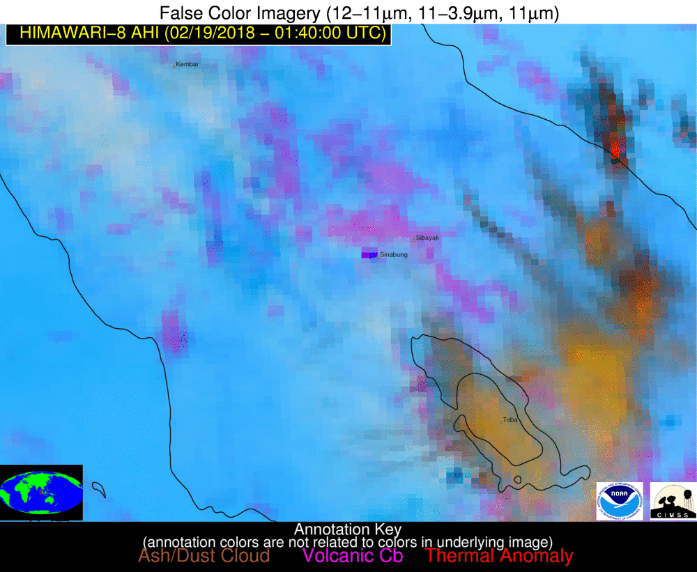
An explosive eruption of Mount Sinabung began at 0153 UTC on 19 February 2018. Himawari-8 False-color Red-Green-Blue (RGB) images from the NOAA/CIMSS Volcanic Cloud Monitoring site showed the primary plume of high-altitude ash moving northwestward, with ash at lower altitudes spreading out to the south and southeast of the volcano. Multi-spectral retrievals of "Ash Cloud Height" indicated that the explosive eruption injected volcanic ash to altitudes generally within the 12-18 km range, possibly reaching heights of 18-20 km. Courtesy University of Wisconsin/CIMSS, NOAA
While the South Pacific has held its breath over the fate of Bali’s roaring Mount Agung, another volcano in the vicinity has been letting off its own steam. Mount Sinabung is among more than 120 active volcanoes in Indonesia, which is prone to seismic upheaval due to its location on the Pacific "Ring of Fire," an arc of volcanoes and fault lines encircling the Pacific Basin. The volcano in North Sumatra, which has been active since 2010 after centuries of dormancy, had its strongest eruption in five years on Monday morning.

A Terra MODIS True-color RGB image viewed using "RealEarth" is shown below. The time of the Terra satellite overpass was 0410 UTC. Courtesy University of Wisconsin/CIMSS, NOAA, NASA
Indonesia, the world’s largest island country with more than thirteen thousand islands, is highly unstable resulting in numerous volcanoes and frequent earthquakes. Remaining dormant for over four centuries, the Mount Sinabung volcano, located just 25 miles from the Lake Toba supervolcano, first showed activity in August 2010, displacing 6,000 of the 30,000 local villagers when a minor eruption spewed lava across the region.The 8,071 ft tall mountain is among Indonesia's most active and dangerous volcanoes.
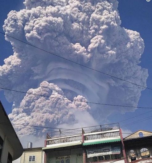
An amazing view of the rising eruption column of the Sinabung volcano (Sumatra island, Indonesia) on Feb 19 featuring pileus clouds.
The eruption of Mount Sinabung on Monday shot ash 3 miles (5 kilometers) high and blew away much of the mountain's summit. Streets were left covered in thick ash and debris is making visibility difficult for rescue operation teams. Thousands were evacuated and more than a dozen people were killed when Mount Sinabung erupted in early 2014. Just over 1,000 miles southeast of Mount Sinabung, the capital city, Jakarta, remains shrouded in darkness due to the 23,000-foot ash cloud blanketing the sky.

Map of Indonesia with arrows pointing to the locations of Mount Sinabung (left) and Mount Agung (right)
The eruption of Mount Sinabung was captured by satellite systems such as the Himawari-8 and Terra MODIS with multiple frames shown in a loop (above) during the first hour after the outburst.
Meteorologist Paul Dorian
Vencore, Inc.
vencoreweather.com