
1:15 PM | *****Major snowstorm continues in Philly-to-NYC corridor with intense snow bands and possible thunder snow*****
Paul Dorian
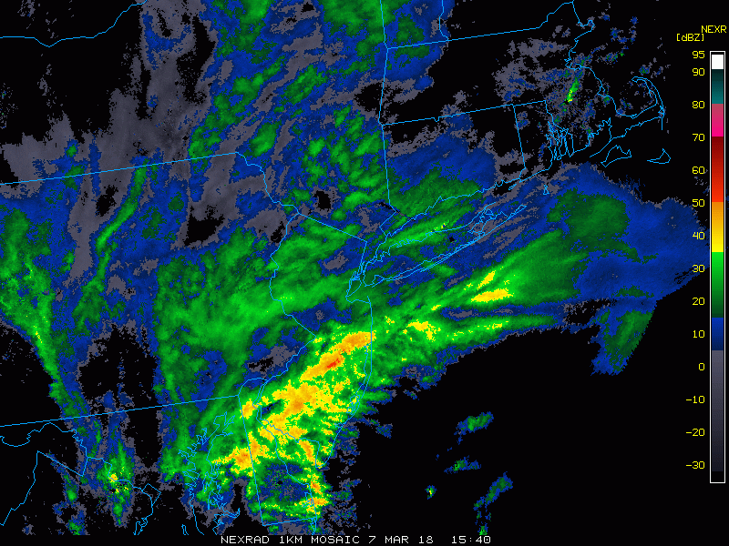
Latest radar loop with heavy precipitation bands across eastern PA and NJ; courtesy College of DuPage, NOAA
The next few hours will feature intense snow bands across eastern PA, interior NJ and southeastern NY with as much as 2-3 inches per hour in some spots. As a result of tremendous dynamics associated with this system, thunder snow is also a possibility in some areas and this would be associated with intense snowfall rates for a brief period of time. Latest radar echoes show heavy precipitation bands rotating around the intensifying low pressure area and this will be the case through much of the afternoon. Given the significant accumulations of heavy, wet snow, power outages are indeed a concern as some tree limbs could be weighed down to their breaking point.

Early afternoon forecast map from 12Z NAM (3-km) with intense snow bands (shown in red, dark blue); map courtesy NOAA/EMC, tropicaltidbits.com
The snow winds down late this afternoon in the Philly metro region and early tonight in NYC. Driving conditions will be treacherous in times of intense snow and temperatures will hold near the freezing mark. Total accumulations of up to a foot is possible by the end of the storm in some of the northern and western suburbs in the Philly-to-NYC corridor with lesser amounts in the big cities. The DC metro region is escaping the action today as it is primarily taking place to its northeast. This is largely a rain event at the southern New Jersey coastline with flooding the biggest concern for now, but accumulating snow will likely fall near the end. The next storm threat comes on Sunday/Monday - too early to say how far north it'll come.
Meteorologist Paul Dorian
Vencore, Inc.
vencoreweather.com