
12:00 PM | *Wild weather coming with near 80 degrees followed by the dreaded back door cold front followed by a heavy rain event with possible strong-to-severe thunderstorms*
Paul Dorian

06Z GFS surface forecast map for early Monday morning with heavy rain and possible strong-to-severe thunderstorms likely in the Mid-Atlantic region; map courtesy NOAA/EMC, tropicaltidbits.com
Overview
“April is the cruelest month” so said T.S. Eliot many, many years ago. Just when it looks like spring has sprung for good and the winter cold is over, temperatures can change on a dime in the Northeast US during the early part of the spring. It is this time of year when temperatures can drop from the 70’s to the 40’s in a matter of hours in places like Boston, New York, Philly and DC if the “dreaded back door cold front” moves in from the northeast. In fact, this appears to be a strong possibility this weekend as a dramatic drop in temperatures may occur between Saturday and Sunday in at least parts of the I-95 corridor with southwest winds shifting to a northeasterly direction. By Sunday night, a deep upper-level low and a strong surface cold front will begin to approach the eastern states and this setup is likely to result in a heavy rain event for DC, Philly and NYC in the Sunday night/Monday morning time period and there can be strong-to-severe thunderstorms included. Following this heavy rain event, much cooler air will push in from the Midwest in a more conventional west-to-east direction, and it looks like it’ll stay colder-than-normal right into the latter stages of the month.
Major warm up
A major warm up will begin in earnest on Thursday in the Mid-Atlantic region as low-level winds increase in intensity from a southwesterly direction and help to push milder air into the area from the south-central US. Despite numerous clouds on Thursday and possible showers north of the PA/MD border, temperatures should climb into the 60’s in DC, Philly and NYC and this will be just the opening stages of the warm up. Even warmer air will surge northward on Friday and Saturday and high temperatures on those two days are likely to average out in the mid-to-upper 70’s in the DC-to-Philly-to-NYC corridor and 80 degrees is quite possible in numerous spots. Big changes in temperatures, however, are likely in much of the I-95 corridor between the first half of the weekend and the second half.
Dreaded back door cold front
Early in the weekend, very strong and cold high pressure will be expanding from south-central Canada into southeastern Canada. Very cold air for this time of year will begin to push down the New England coastline from northeast-to-southwest following the passage of the “dreaded back door cold front”. Long-time residents of the Northeast US know very well of the “back door cold front” and how it has a tendency to take place this particular time of year. The conventional cold front in this part of the country moves in from the west or northwest whereas a "back door cold front" approaches from the northeast or east.
One of the main contributing factors to this atmospheric phenomenon this time of year is the still quite chilly waters of the nearby western Atlantic Ocean. A shift in wind direction from southwest to northeast – as is typically the case with the passage of a "back door cold front" – can drop temperatures dramatically from the 70’s to the 40’s or even lower in just a matter of hours. This is indeed a real possibility this weekend in places like New York City where temperatures on Saturday could reach the mid-to-upper 70's and then be confined to the 40’s on Sunday. The cooler air is likely to make it all the way down into the Philly and DC metro regions with considerably cooler conditions also possible there on Sunday compared to Saturday’s unusual warmth.

06Z GFS forecast map of 500 mb height anomalies for early Monday morning with deep upper-level trough of low pressure (blue) and an associated strong surface cold front likely contributing to a heavy rain event here in the Mid-Atlantic region on Sunday night and Monday that could include strong-to-severe thunderstorms; map courtesy NOAA/EMC, tropicaltidbits.com
Heavy rain event with possible strong-to-severe thunderstorms
By Sunday night, deep upper-level trough of low pressure from the middle of the country will begin to push into the eastern US and it will feature a strong surface cold front that will be moving in the more conventional direction of west-to-east. Given this “atmospheric squeeze play” with cold air first pushing in from the northeast and cold air pushing in from the west, it is no wonder the spring warmth will have little chance of surviving around here as we being the new week. This overall setup is likely to lead to a heavy rain event around here from late Sunday into Monday and there can be strong-to-severe thunderstorms mixed into the picture.
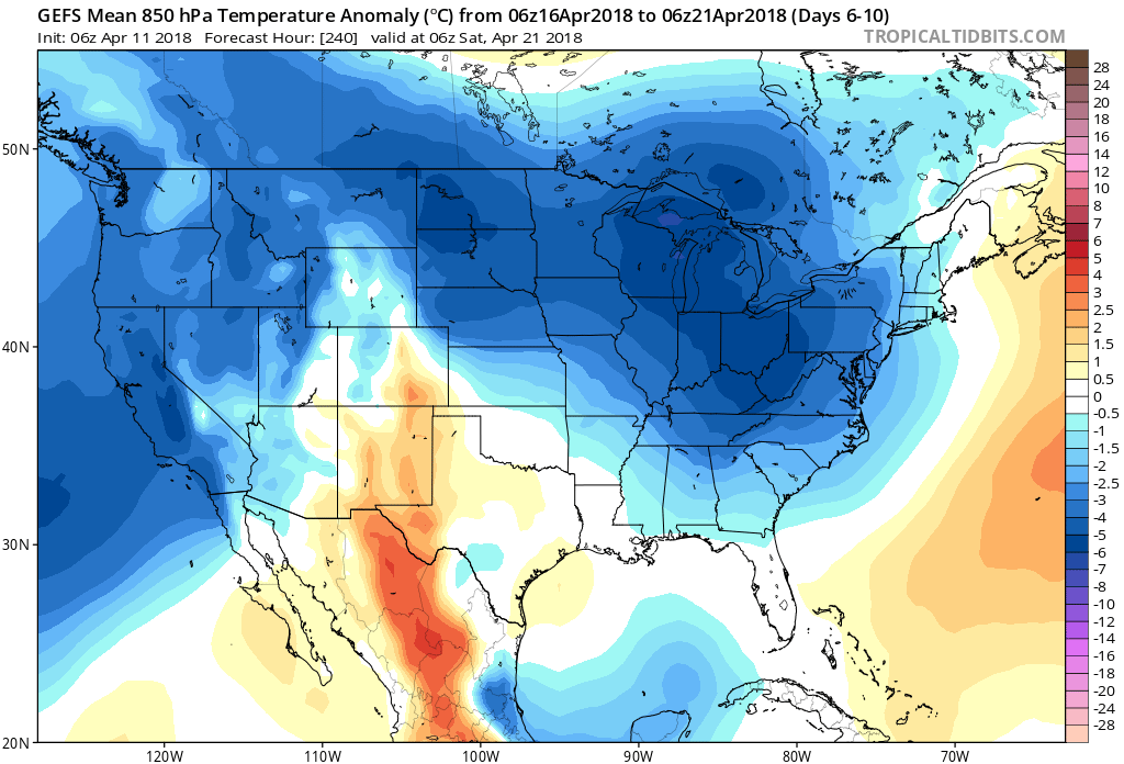
06Z GEFS forecast map of 850 mb temperature anomalies averaged over days 6-10 (April 16-21) with much of the eastern two-thirds of the nation back to below-normal conditions; map courtesy NOA/EMC, tropicaltidbits.com
The chill returns
Following the heavy rain event on Sunday night and early Monday, much cooler air from the Midwest will push into the eastern US and it looks like it’ll stay colder-than-normal on average right into the latter stages of the month of April. The forecast maps of the 5-day averages of 850 mb temperature anomalies for days 6-10 and days 11-15 show lots of “blue” (i.e., colder-than-normal) next week and beyond to near the end of April and this will take place in much of the same region that experienced the cold during the first part of the month (i.e., eastern two thirds of the nation). The bottom line…make sure to enjoy the warmth on Thursday, Friday and Saturday as indeed, “April is the cruelest month”.

06Z GEFS forecast map of 850 mb temperature anomalies averaged over days 11-15 (April 21-26) with much of the eastern two-thirds of the nation back to below-normal conditions; map courtesy NOA/EMC, tropicaltidbits.com
Meteorologist Paul Dorian
Vencore, Inc.
vencoreweather.com
Extended morning video discussion on the wild weather coming in the Mid-Atlantic region over the next several days: