11:20 AM | *Severe weather outbreak later today/tonight in the southern and central Plains*
Paul Dorian

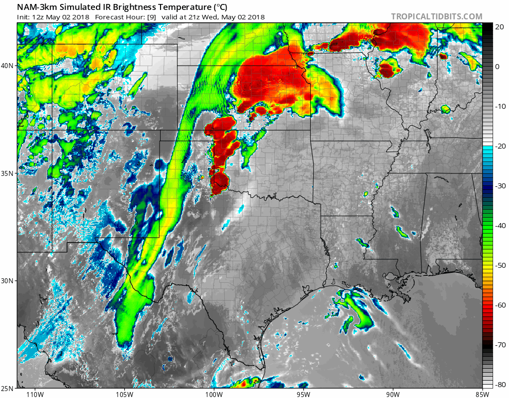
12Z NAM (3-km version) forecast maps of simulated IR brightness temperatures from late today into tonight with explosive thunderstorm development from Texas-to-Iowa; maps courtesy NOAA/EMC, tropicaltidbits.com
Overview
There were unofficially as many as 21 tornadoes yesterday in the central and southern Plains and one of those apparently took place in the state of Oklahoma. The National Weather Service has not yet confirmed any of yesterday’s storm reports and the possibility of one in the state of Oklahoma is important since it would be the first of the calendar year and the latest ever for their first tornado. A more widespread severe weather outbreak is likely later today and there can be damaging wind gusts, softball-sized hail, and tornadoes from Texas-to-Iowa as favorable conditions come together in that part of the country.

06Z GFS forecast map for early tonight of 500 mb height anomalies with a "clash" setting up in the center part of the nation between the cold upper-level low over the Southwest US and the strong high pressure ridging in the eastern US; map courtesy NOAA/EMC, tropicaltidbits.com
Details
Several ingredients are coming together for a severe weather outbreak later today and tonight in the central and southern Plains. A broad closed low in the upper part of the atmosphere will move slowly eastward today across the southwestern US. The air mass associated with this upper-level low is quite cold and there actually is snow falling today in some of the higher elevation regions of the southwestern US. Southwesterly flow aloft will contribute to storm formation across southeast Colorado later today and a dry line will form over the Texas Panhandle and push to the northeast. At the same time, strong southerly flow of air will form over the southern states on the backside of western Atlantic high pressure and push Gulf of Mexico moisture northward right into the southern and central Plains.

NOAA's Storm Prediction Center mid-day update forecast map of the severe weather outlook for later today and tonight with the highest probability from northwestern Oklahoma to northwestern Missouri; map courtesy NOAA/SPC (in Norman, Oklahoma)
The severe weather threat later today will include damaging wind gusts of up to 80 mph, hail on the order of softball-sized, and tornadoes. The latest high-resolution model information highlights the western part of Oklahoma as an area to watch late today for explosive thunderstorm development and then by later tonight there is likely to be several lines of strong-to-severe thunderstorms extending from Texas-to-Iowa.
Meteorologist Paul Dorian
Vencore, Inc.
vencoreweather.com
Morning video discussion on the severe weather outbreak in the center of the nation and the summer-like weather in the Mid-Atlantic region: