12:55 PM | *Strong weekend coastal storm begins very wet pattern for the eastern seaboard*
Paul Dorian

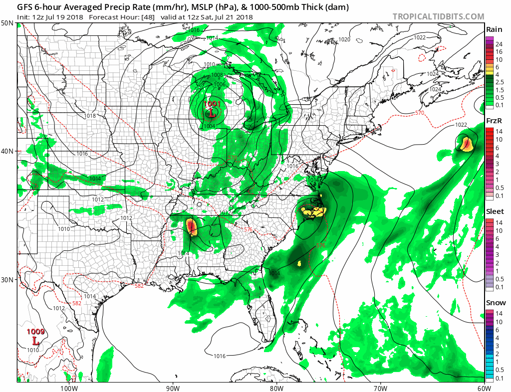
12Z GFS surface forecast maps from Saturday morning (48-h) to Sunday morning (72-h) in 6-hour increments featuring low pressure along the Mid-Atlantic coastline; courtesy NOAA/EMC, tropicaltidbits.com
Overview
A very wet pattern is unfolding for much of the eastern third of the nation and it’ll begin this weekend with the formation of a deep “negatively-tilted” upper-level trough of low pressure over the Ohio Valley. This upper-level system will become a slow-mover and it will contribute over the next several days to a persistent flow of air into the Mid-Atlantic region from the tropical Atlantic. In addition, there will be the development of a strong surface low pressure system along the Mid-Atlantic coastline on Saturday which will likely bring heavy rainfall and strong winds to coastal sections from the Delmarva Peninsula-to-southern New England and perhaps even inland to the immediate I-95 corridor. By the time next weekend rolls around, several inches of rain could have fallen in much of the eastern US and localized flooding may become a serious concern.

An unusually deep upper-level trough for July will form over the Ohio Valley this weekend and become a major player in the unfolding very wet pattern; courtesy NOAA/EMC, tropicaltidbits.com
Details
An unseasonably strong “negatively-tilted” upper-level trough will form over the Ohio Valley early this weekend and the DC-to-Philly-to-NYC corridor will be situated in the northeast quadrant of this system for awhile. In this particular quadrant of the upper-level low, upward motion will become quite strong and this will help in the formation of a surface low pressure system along the Mid-Atlantic coastline. This surface low is first likely to appear near the Carolina coast early on Saturday and then it should undergo intensification as it rides up along the Mid-Atlantic coast. As a result, some heavy rain and strong winds are possible later Saturday/Saturday night from the Delmarva Peninsula-to-southern New England and this storm impact could extend inland to the immediate I-95 corridor.

Even after the initial coastal storm passes by, the wet pattern will persist with a consistent flow of air from the tropical Atlantic into the Mid-Atlantic region (12Z GFS surface forecast map for early Tuesday afternoon, courtesy NOAA/EMC, tropicaltidbits.com)
Once this initial low pressure system passes by on Sunday, the overall wet pattern will remain in place as the upper-low will be slow to move and tropical moisture will continue to feed in from the Deep South and tropical Atlantic. The threat for showers and thunderstorms will continue on Sunday and quite likely right through all of next week. This pattern does not mean that each and every day will be a washout, but it should result in substantial total rainfall amounts around here over the next 7-10 days.

NOAA's prediction of total rainfall amounts between today and next Thursday (7-days)
Meteorologist Paul Dorian
Perspecta, Inc.
perspectaweather.com