11:25 AM | *Hurricane Florence remains a threat to the US east coast for mid-to-late next week…the remains of Gordon to contribute to a swath of heavy rainfall*
Paul Dorian

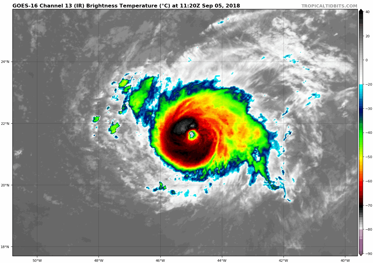
Florence has strengthened to major hurricane status (category 3) and it remains a threat to the US east coast; courtesy NOAA/GOES, tropicaltidbits.com
Overview
The climatological peak of the Atlantic Basin tropical season comes in mid-September and this year is certainly holding true to form. Tropical Storm Gordon came ashore overnight in the vicinity of the Alabama/Mississippi border region and is now well inland over the central part of Mississippi. While Gordon has been downgraded to tropical depression status, it is likely to contribute to an extended swath of heavy rainfall in coming days. Meanwhile, Florence has intensified into major hurricane (category 3) status out over the central Atlantic. There is still a chance that Florence gets “captured” by an eastward-moving upper-level trough of low pressure this weekend over the north Atlantic, but odds favor it being “left behind”. If indeed Florence is not “captured” by the trough this weekend then strong and expanding high pressure ridging to the north early next week could very well steer it westward towards the US east coast. Any potential impact on the US east coast by Hurricane Florence would likely come during the middle or latter part of next week.

Remains of TD Gordon will head northeast this weekend and contribute to a wide swath of heavy rainfall from the south-central US to the Mid-Atlantic region; map courtesy weatherbell.com, ECMWF
Gordon
At 11am, Tropical Depression Gordon had max sustained winds of 30 mph and is moving northwesterly at 14 mph. Gordon should slow down a bit and drift to the NW over the next couple of days, but will then transition to a northeasterly direction this weekend and move across the Midwest and towards the eastern Great Lakes.

Swath of heavy rainfall over the next 7 days partly as a result of the remains of TD Gordon; courtesy NOAA
Moisture associated with the remains of Gordon will combine with a stalled out frontal boundary zone to generate a swath of heavy rainfall from the south-central US to the Mid-Atlantic region over the next several days.

Hurricane Florence has a chance to be "picked up" by an eastward-moving upper-level trough this weekend and head to the north; however, it remains a threat to the US east coast as it could end up "sliding under" the trough and heading to the west later next week; map courtesy weatherbell.com, ECMWF [black represents the storm track for the ensemble mean, blue represents the storm track for the deterministic model]
Florence
Florence has just become the first major (category 3) hurricane of the 2018 Atlantic Basin tropical season with max sustained winds at 125 mph and is moving NW at 13 mph. It is actually quite impressive that Florence has strengthened into major hurricane status in recent hours given its current location over colder-than-normal waters as well as being in the vicinity of some dry (Saharan Desert) air.

Hurricane Florence has intensified despite moving over colder-than-normal water; map courtesy NOAA, tropicaltidbits.com
In coming days, Hurricane Florence will actually head over warmer-than-normal water in the Atlantic Ocean and this will be favorable for additional intensification.

Hurricane Florence has intensified despite being surrounded by dry air; map courtesy University of Wisconsin/CIMMS, NOAA
Florence poses no threat to land through at least the upcoming weekend. Looking to next week, however, there are two possibilities with respect to its storm track. In one scenario, an eastward-moving trough of low pressure that is likely to be over the north Atlantic Ocean this weekend may “capture” Florence and “pull” it towards the north Atlantic without it ever posing a threat to the US east coast. However, in a second and perhaps increasingly more likely scenario, Florence could be “left behind” by the trough and then it will come under the influence of a strong and expanding ridge of high pressure that will return to the SE Canada/Northeast US/northwest Atlantic region by early next week. Once this system sets up, the door will be open for Florence to head to the west and right towards the US east coast. Any potential impact on the US east coast by Florence is likely to take place during the middle or latter part of next week.

500 mb height anomaly pattern was quite similar for the arrival of Hurricane Andrew in August 1992 compared to the model predictions for early next week with very high heights over SE Canada/Northeast US/northwest Atlantic; maps courtesy NOAA, tropicaltidbits.com
Some upper-level pattern similarities to Hurricane Andrew
In August 1992, Hurricane Andrew pushed westward across the southwestern Atlantic and made landfall in southern Florida before moving out over the Gulf of Mexico. The upper air pattern in the days surrounding Andrew’s approach to Florida featured strong high pressure ridging over the southeastern part of Canada, northeastern US and the northwest Atlantic – quite similar to what the setup could be early next week following the passage of the all-important eastward-moving trough.
Stay tuned…hopefully, Florence gets “captured” by the upper-level trough this weekend and heads north into the open Atlantic, but odds are increasing for it to remain left behind and ultimately a threat to the US east coast. One final note, yet another tropical system trails Florence in the far eastern Atlantic and it may intensify and take a “southern route” in coming days and heads towards the Caribbean Sea.
Meteorologist Paul Dorian
Perspecta, Inc.
perspectaweather.com
Extended video discussion on Tropical Depression Gordon and the east coast threat from major Hurricane Florence: