
9:00 AM (Sunday) | *****Winter storm gets underway shortly in the Mid-Atlantic region and generates significant snowfall in many suburban locations…widespread Arctic cold to follow*****
Paul Dorian

12Z NAM surface forecast map with snow in blue, rain in green/yellow; courtesy NOAA/EMC, tropicaltidbits.com
Overview
A significant winter storm will impact the Mid-Atlantic region from this afternoon into early Monday morning. Low pressure will intensify as it takes a track towards the southeastern Virginia coastline by later tonight and then it moves quite rapidly to a position off the southern New England coastline by early Monday. Significant snow accumulations are likely in many northern and western suburbs along I-95; especially, in areas north of the PA/MD border. An Arctic air mass will flood the eastern half of the nation following the storm with way below-normal temperatures for the first full week of March.

12Z NAM surface forecast map with snow in blue, rain in green/yellow; courtesy NOAA/EMC, tropicaltidbits.com
Breakdown of timing and snowfall by metro region
DC: Precipitation is likely to break out as snow in the far western suburbs (e.g., near Dulles) during the late morning or mid-day hours and as a rain/snow mix along and just to the NW of I-95 and likely as rain to the south and east of there. The precipitation will remain mainly as snow in the far northern and western suburbs although sleet and rain can mix in at times and it’ll battle back-and-forth between rain, sleet and snow elsewhere in the DC metro region later today although snow will become the dominate precipitation type for awhile. The precipitation tapers off rather quickly in the overnight hours and any untreated surfaces can get slick as temperatures hover near freezing.
Snowfall estimates: a coating to two inches in the District and nearby points south and east of the city, 2-4 inches in the nearby northern and western suburbs, 3-6 inches in the far northern and western suburbs (e.g., Northwest Montgomery, Northwest Howard and Northern Loudoun Counties)

HRRR forecast map for 7PM Sunday evening…north and west suburbs of SE PA in “sweet spot” for this storm (and to the northeast of there)…perhaps 2-3 inches of snow per hour; map courtesy NOAA/EMC
Philly: The precipitation may begin as a mix of light rain and snow during the early-to-mid afternoon hours in and around Philly, but as the precipitation gets heavier later in the afternoon it’ll changeover to all snow and accumulations will begin. The snow will get very heavy at times for the evening hours (5-10pm) and this will be a time of more rapid snow accumulations (perhaps 2-3 inches per hour). The snow can mix with sleet and/or rain at times late this evening and in the overnight hours and could even change to all rain for awhile in areas well south and east of the city of Philadelphia (e.g., southern NJ). Finally, any mixed precipitation can then change back to snow late tonight before winding down completely as the low pressure system moves away.
Snowfall estimates: 3-5 inches in the city of Philadelphia and nearby points south and east of the city, 4-8 inches in the northern and western suburbs with isolated 10 inch amounts possible
NYC: Precipitation arrives in the mid-to-late afternoon hours likely as a mix of rain and snow and then a transition to all snow should take place by early evening. Snow will fall tonight, heavily at times, and there can be sleet and rain mixing in at times. The best accumulations will take place from around 9pm to 3am and precipitation winds down early Monday morning.
Snowfall estimates: 4-8 inches on average throughout the metro region with isolated 10 inch amounts possible
Note- this is the kind of storm in which elevation can make a big difference in terms of snow accumulations…a few hundred feet in altitude difference can mean the difference of a few inches of snow
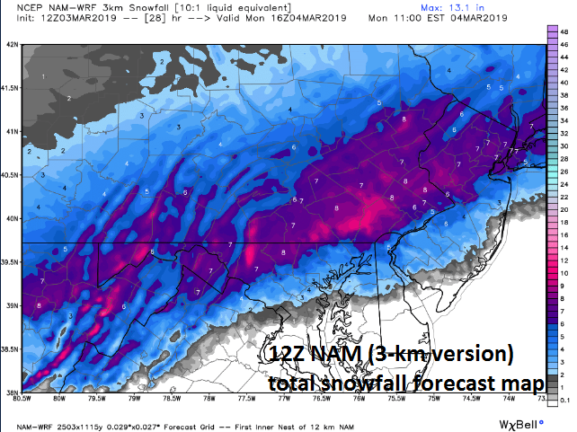
Snowfall forecast map by the 12Z NAM (3-km version); courtesy Weather Bell Analytics, NOAA/EMC
Arctic cold to follow
Perhaps even more important than the upcoming snowfall will be the widespread bitter cold air outbreak this week for much of the nation. Following today’s storm, Arctic air will flood the eastern half of the nation and temperatures this week will be well below-normal for early March. It is not out of the question that some suburbs of Philly and NYC see overnight low temperatures bottoming out this week in the upper single digits to lower teens with low-to-mid teens possible for lows in the DC suburbs.

Widespread cold for the first week of March; courtesy NOAA/EMC, tropicaltidbits.com
Stay tuned for any last minute tweaks in timing and/or snowfall estimates.
Meteorologist Paul Dorian
Perspecta, Inc.
perspectaweather.com