
12:30 PM (Monday) | *Tropical threats not over yet for Gulf of Mexico, southeast US…unfolding weather pattern is favorable for potential impact next week*
Paul Dorian

Hurricane Eta has strengthened into a strong category 2 storm with an “eye” and it is likely to reach “major” hurricane status before making landfall early Tuesday on the east coast of Nicaragua. Image courtesy College of DuPage, NOAA
Overview
The calendar has flipped to November, but the unfolding weather pattern suggests tropical threats are not over just yet for the Gulf of Mexico and southeast US. Hurricane Eta has strengthened into a strong category 2 storm in the western Caribbean and it is headed for a landfall in Central America in the near term – likely as a “major” hurricane (i.e., category 3 or higher). In fact, there is a decent chance that Hurricane Eta strengthens into category 4 “major” hurricane status before making landfall early Tuesday in the country of Nicaragua. After landfall, Hurricane Eta will push westward and likely reach Honduras later in the week and then it may skirt Belize as it heads back to the open waters of the still warm western Caribbean Sea. It is at this time that the concern may begin to increase significantly for residents in the Gulf of Mexico and Southeast US as whatever remains of Eta could re-strengthen and push northward towards the US by early next week.
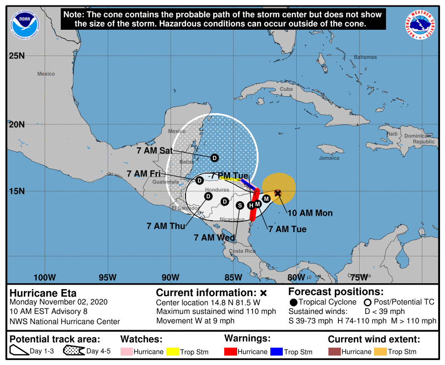
Hurricane Eta will have a major impact on the Central America countries of Nicaragua and Honduras over the next few days. Map courtesy NOAA/NHC
Details
Hurricane Eta has intensified into a strong category 2 storm at mid-day with a visible “eye” and maximum sustained winds of 110 mph. Eta has a good chance for additional strengthening over the next several hours into a “major” hurricane and it can intensify all the way to category 4 classification before making a likely landfall early Tuesday on the east coast of Nicaragua. It is moving westward at only 10 mph and may slow down further later today. Given its strength and slow movement, Hurricane Eta may be able to produce incredible rainfall amounts in Central America over the next couple of days with more than 2 feet possible in Nicaragua and Honduras – despite weakening along the way. There have been three category 4 hurricanes in the Atlantic Basin during the month of November as follows: Lenny (1999), Michelle (2001) and Paloma (2008) and one category 5 (unnamed) in 1932 that impacted the island of Cuba.

High pressure will build into the Northeast US/Southeast Canada in coming days and this often results in tropical troubles to its south in the Gulf of Mexico/SW Atlantic. Map courtesy NOAA, tropicaltidbits.com
After Hurricane Eta impacts Nicaragua and Honduras, it is likely to turn back to the north and skirt Belize on its way back to the open warm waters of the western Caribbean by the end of the week. It is at this point that the remnants of Eta may become an increasing concern for residents in the Gulf of Mexico and Southeast US. The overall weather pattern that is unfolding is conducive to a re-strengthening of whatever remains of Eta when it returns to a position over the open waters of the western Caribbean. Specifically, strong high pressure ridging will form over the southeastern part of Canada/Northeast US in coming days and this will allow for formation and/or intensification of tropical activity in the Gulf of Mexico/SW Atlantic. The upper-level wind flow that is to form in coming days will likely allow for this tropical system to push north early next week – perhaps right into the southern Gulf of Mexico. All eyes along the US Gulf coast and southeast US coastline will need to monitor closely this tropical threat for a possible impact sometime next week. Despite the switch on the calendar to November, the very active 2020 Atlantic Basin tropical season is not quite ready to pack it in for the year.
Meteorologist Paul Dorian
Perspecta, Inc.
perspectaweather.com
Follow us on Facebook, Twitter, YouTube
Video discussion: