
11:45 AM (MON) | *Heavy rain, strong winds in Mid-Atl/NE US late Thursday - just ahead of strong cold front…quick temperature drop early Friday with snow showers…energetic pattern continues next week*
Paul Dorian
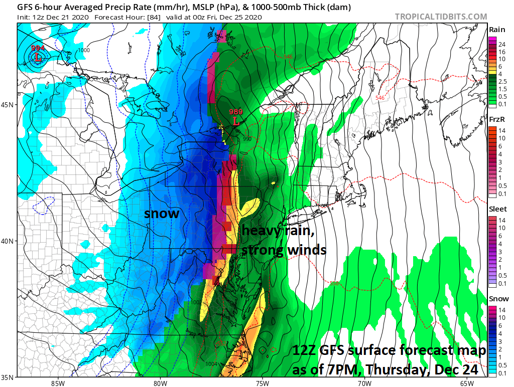
A strong cold front will feature heavy rain and strong winds ahead of it on Thursday evening and a changeover to accumulating snow behind it across interior sections from West Virginia to western NY. Map courtesy NOAA, tropicaltidbits.com
Overview
An active weather pattern continues this week in the central and eastern US with the main weather event being the late week passage of a powerful Arctic cold frontal system. This front will result in a heavy rain event for the Mid-Atlantic/NE US from late Thursday into Thursday night which will be accompanied by strong winds, mild conditions and a possible thunderstorm. With snow cover still in place in many areas north of the PA/MD border, the upcoming heavy rain event may lead to localized flooding conditions.
Behind the front, temperatures will drop sharply potentially leading to a quick ice-up in some spots and inland areas from West Virginia to central/western NY will likely see accumulating snow. In fact, there can even be some small accumulations of snow early Friday in the I-95 corridor on the heels of the frontal passage; especially, in some of the northern and western suburbs. The much colder air that arrives on Christmas Day (Friday) will stick around into the upcoming weekend and next week promises to be quite energetic with the potential of multiple storm threats to monitor.

A heavy rain event is coming to the Mid-Atlantic/NE US from late Thursday into Thursday night. This heavy rainfall will be just ahead of a strong Arctic cold front and it will be accompanied by strong winds, mild conditions and possible thunderstorms. Map of 24-hour total precipitation amounts courtesy NOAA, tropicaltidbits.com
Details
Christmas Eve (Thursday) is likely to begin with decent snow cover in many areas of the Mid-Atlantic/NE US, but a lot of it may be washed away by the time Christmas morning rolls around; especially, in the I-95 corridor region. Heavy rain is likely late Thursday and Thursday night - just ahead of a strong Arctic cold front - and it’ll turn much milder with highs well up in the 50’s in the DC-to-Philly-to-NYC corridor. In addition to the heavy rain and milder conditions, winds will become an important factor later Thursday and Thursday night with possible gusts past 50 mph. It is also possible that some thunderstorm activity develops along the cold front as it crosses the eastern states in a west-to-east fashion.

A cold air mass will blast into the eastern states on Friday following the passage of a strong Arctic cold front. Map courtesy NOAA, tropicaltidbits.com
Behind the strong cold front, temperatures are likely to drop quickly (25 degrees in 3 hours) to below the freezing mark and this could result in a quick ice-up in some spots. The rain will change to snow is many parts of the Mid-Atlantic/NE US and accumulations are quite likely in interior sections from West Virginia to central/western New York State. In fact, there is a chance for small accumulations of snow in the I-95 corridor early Friday as the colder air pours into the region. High pressure takes control at week’s end and it’ll stay very cold on Saturday with highs struggling to reach the freezing mark in the DC-to-Philly-to-NYC corridor.
Looking ahead, an energetic pattern is in the offing for next week and beyond across the central and eastern US. In fact, there is the threat next week for at least a couple of storm systems to deal with – one early in the week and the other late next week - just in time for New Year’s Eve/New Year’s Day (i.e., Thursday/Friday). It is still way too early for any details on next week, but the overall pattern suggests these threats will be something to closely monitor as we progress to the end of December and the beginning of the New Year.
Stay tuned…this interesting weather pattern is likely to continue well into January 2021.
Meteorologist Paul Dorian
Perspecta, Inc.
perspectaweather.com
Follow us on Facebook, Twitter, YouTube
Video discussion: