
11:15 AM | *Brief period of sleet/freezing rain possible in suburban locations at onset of late week storm system...second system to impact the Mid-Atlantic region on Sunday...a look ahead to January*
Paul Dorian
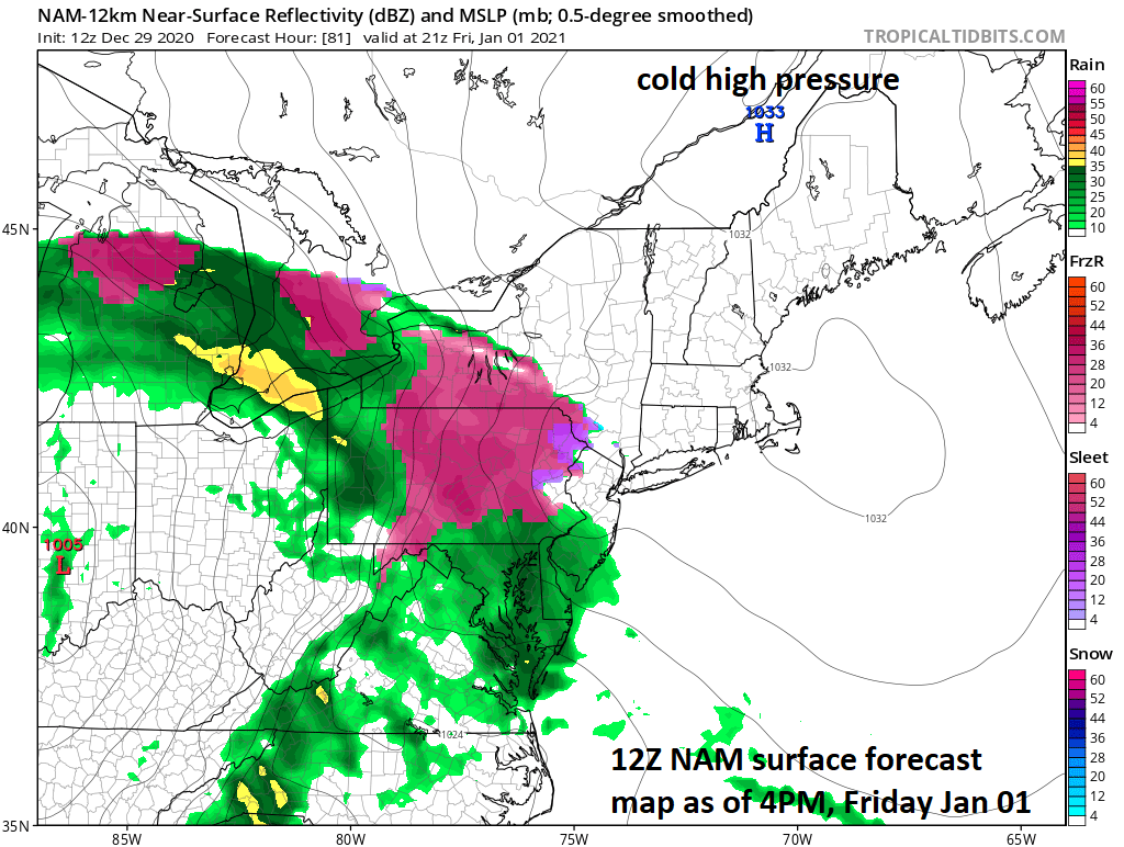
Low-level cold air will be slow to retreat on Friday and this could lead to a brief period of sleet and/or freezing rain in the Mid-Atlantic region. Map courtesy NOAA, tropicaltidbits.com
Overview
An active weather pattern will continue into the new year for the eastern half of the nation with one low pressure system bringing a potpourri of precipitation on Friday and then a second system late in the weekend that should intensify near the Mid-Atlantic coastline. The first system will result in accumulating snow for parts of the Upper Midwest and Ohio Valley on New Year’s Day (Friday) and mainly a rain event for the Mid-Atlantic region. However, it can be cold enough at the onset on Friday in the Mid-Atlantic region for a brief period of sleet and/or freezing; especially, in areas north of the PA/MD border. Late in the weekend, a second low pressure system will likely intensify near the Mid-Atlantic coastline and it would have an influx of colder air – a potential setup that needs to be monitored in coming days.

An initial wave of energy will aid in the formation and intensification of a late week storm system for the eastern half of the nation and a second area of energy could spawn the formation of a late weekend storm system near the eastern seaboard. Map courtesy NOAA, tropicaltidbits.com
Late week storm/late weekend threat
A cold frontal system slipped through the Mid-Atlantic in the overnight hours and today has turned out to be a windy and cold day despite plenty of sunshine. High pressure will be in control of the weather at mid-week and then another cold front will works its way through the region later on Thursday. A chilly, dry air mass will follow the frontal passage on Thursday night and it will be supported by building high pressure across northern New England/southeastern Canada. This cold, dry air mass will be somewhat slow to give up its ground on Friday as a large area of moisture heads to the Mid-Atlantic region from the Tennessee Valley – this may set the stage for a brief period of sleet and/or freezing rain in at least parts of the area.
On Friday, surface low pressure will pull out of the south-central states and head towards the Great Lakes – well to the west of the I-95 corridor. At the same time, high pressure will be parked over northern New England/southeastern Canada and it will be somewhat slow to retreat as will some low-level cold, dry air that will be in place across the Mid-Atlantic region. As a result, there can be a brief period of sleet and/or freezing rain on Friday as an area of moisture associated with low pressure over the Midwest reaches us from the Tennessee Valley. In the I-95 corridor from DC-to-Philly-to-NYC, the best chance for the sleet and/or freezing rain will be in the northern and western suburbs at the onset of the late week precipitation event. Eventually, enough milder air will push in at the lower levels of the atmosphere for plain rain to be the dominate precipitation type later on Friday and Friday night across the Mid-Atlantic region. In fact, temperatures are likely to rise on Friday night leading to an unseasonably mild day on Saturday following the departure of the storm system.
Another cold frontal system is likely to push through the Mid-Atlantic region on Saturday night and it’ll turn colder on Sunday. A lingering area of short-wave upper-level energy is then going to rotate around a large scale upper-level trough and it should help to spawn the formation of a second low pressure system over the southeastern part of the US. This system will likely intensify near or over the Mid-Atlantic coastline on Sunday and there will be a marginally cold air mass moving into the region following the passage of the cold frontal system. The odds favor a cold rain in the I-95 corridor from this late weekend storm system, but it’ll be a rather close call and it something that needs to be monitored in coming days.
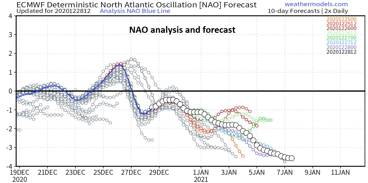
The North Atlantic Oscillation (NAO) teleconnection index and its closely related cousin (Arctic Oscillation) will remain in “negative” territory in coming days and this is often correlated with a cold and stormy weather pattern for the central and eastern US. Plot courtesy weathermodels.com, NOAA
January outlook
Looking ahead, teleconnection indices that are based on pressure and height anomaly patterns across the Arctic and North Atlantic Ocean continue to suggest there will be additional cold air outbreaks in coming weeks for the central and eastern US and that the overall active weather pattern will continue well into the month of January. Specifically, the Arctic Oscillation (AO) and North Atlantic Oscillation (NAO) teleconnection indices are now in “negative” territory and will remain so in coming days - this is often correlated with a cold and stormy weather pattern for the central and eastern US.
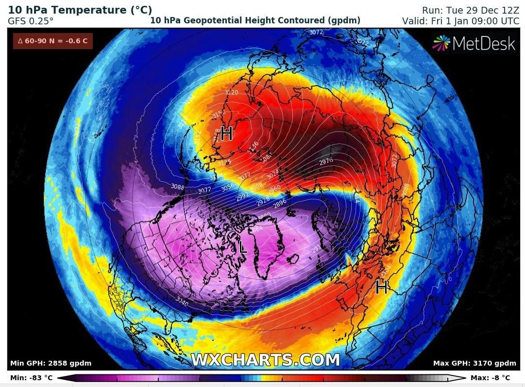
A “stratospheric warming” event will bring significant warming aloft to the Asian side of the North Pole by week’s end. This unfolding “stratospheric warming” event can have important ramifications on the overall weather pattern across Canada and the US during the month of January. Map courtesy wxcharts.com, NOAA
In addition to the clues provided by trends in teleconnection indices, something else to monitor is an unfolding “stratospheric warming” event happening now across higher latitude areas of the Northern Hemisphere. This type of weather phenomenon can result in some interesting weather patterns for Canada and US in subsequent weeks – something we’ll closely monitor as we progress through the first month of 2021.
Meteorologist Paul Dorian
Perspecta, Inc.
perspectaweather.com
Follow us on Facebook, Twitter, YouTube
Video discussion: