
12:00 PM (Mon) | *Colder pattern continues to unfold for the northern US during the second half of January…severe cold, snow has pounded parts of Europe and Asia following stratospheric warming event*
Paul Dorian

There was a spike in stratospheric temperatures across polar regions (90N to 65N) in recent weeks and this “stratospheric warming event” has played an important role in the resultant severe cold and snow that subsequently impacted parts of Europe and Asia. Map courtesy NOAA
Overview
A stratospheric warming event that began several weeks ago has set off a chain of events in the atmosphere to bring some severe cold and snow to portions of Europe and Asia in recent days. Meanwhile, much of the northern part of the US has experienced above-normal temperatures in the first ten days of January, but the overall pattern is undergoing some important changes that will likely result in much colder weather during the second half of the month. Specifically, the overall pattern aloft will evolve into one which features high-latitude blocking across Greenland/northeastern Canada and high pressure ridging across the west coasts of Canada and the US. This change will allow for the transport of very cold air masses from northern Canada into the central and eastern US as we progress through the latter half of January.
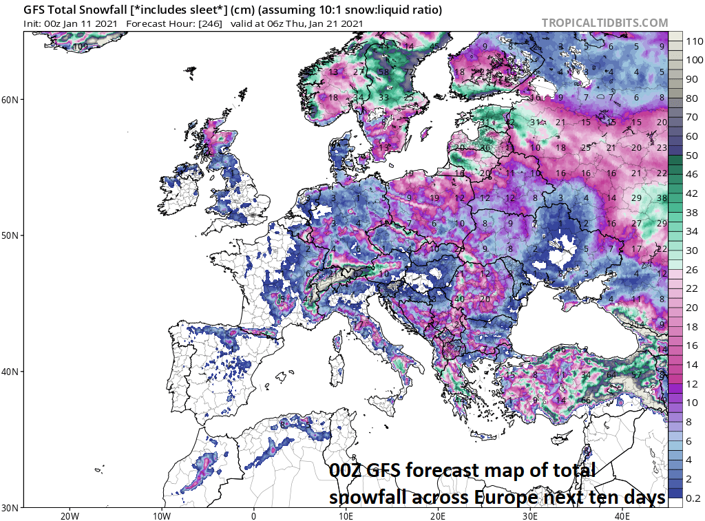
The next ten days will feature more significant snowfall in Europe; especially, in the region from the northern Scandinavian countries to the southern countries of Italy and Greece.
Stratospheric warming/severe cold, snow across Europe, Asia
A stratospheric warming event that began in early December over the polar region of the northern hemisphere began a chain of events in the atmosphere that produced some severe cold and snow in portions of Europe and Asia in recent days. Last week, for example, featured the coldest temperature ever recorded in Spain and this was followed by the biggest snowstorm in 50 years for the capital and most populated city of Madrid. In addition, the Far East has had some severe cold and snow with Beijing, China experiencing their coldest weather since 1966 and Japan experiencing some record cold and incredible snowfall amounts of several feet in spots.

Yesterday featured some serious cold across the Northern Hemisphere with some example minimum temperatures shown here from Russia, Greenland and Canada.

Incredible snowfall amounts have occurred in recent days across Japan to go along with some record cold. Map courtesy Japan Meteorological Agency
The next several days will continue to result in some severe cold and snow on the other side of the North Pole with bitter cold in Russia, for example, and significant snow in Europe from the northern Scandinavian countries to the southern countries of Italy and Greece. It is not all that unusual for stratospheric warming events to bring significant cold (and snow) to this part of the Northern Hemisphere before there is a similar type of impact on the North America side of the North Pole. In addition, there are signs that another stratospheric warming event will take place in polar regions during the next couple of weeks. Indeed, a significant pattern change seems to be evolving that will bring some much colder weather to the northern part of the US as we progress through the second half of January.
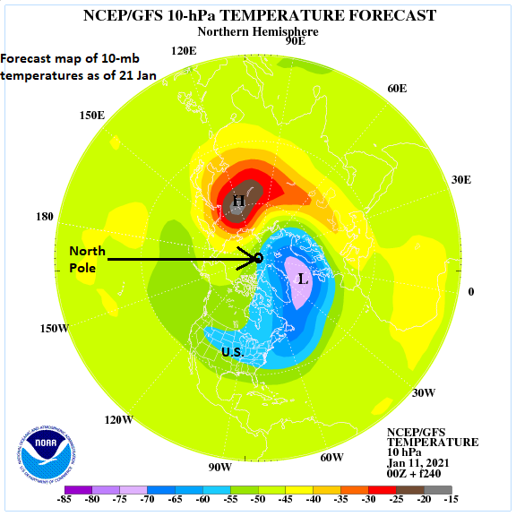
Stratospheric warming may re-intensify in about a week to ten days with the polar vortex displaced some from the North Pole. Map courtesy NOAA
Coming changes for the US
The first ten days of January have featured warmer-than-normal temperatures across much of southern Canada and the northern US including in the Mid-Atlantic region with DC, Philly and NYC some 3 or 4 degrees or so above-normal. Over the next week or so, there will be important changes to the upper atmosphere that will likely result in quite a different scene for the second half of the month across these same regions of southern Canada and the northern US. Specifically, upper-level high pressure ridging will intensify in two parts of North America that should allow for the transport of some very cold air later this month from northern Canada to the northern US.

00Z EPS 500 mb height anomaly forecast map for 16 Jan - 21 Jan features high-latitude blocking over Greenland/northeastern Canada and strong ridging over the western parts of the US and Canada. Map courtesy ECMWF, Weather Bell Analytics
In particular, high-latitude blocking will develop with intensifying high pressure over Greenland and northeastern Canada as well as across the western parts of Canada and the US. The flow of air around the western Canada and US high pressure ridges will not only allow for the transport of air from northern Canada into the US, but it may also produce a “cross-polar” flow that could bring Siberian air (in a modified form) across the North Pole and into North America later in the month. The pattern change will become more noticeable at the end of this week as a strong cold front charges across the eastern states and ushers in colder air for the upcoming weekend. This initial cold air outbreak will most certainly be followed by others as we progress through the second half of January.

The current 5-day period will feature warmer-than-normal conditions across the northern states and colder-than-normal in parts of the southern US. Map courtesy NOAA, tropicaltidbits.com
Colder pattern likely to be quite active
The overall temperature pattern across the US in recent days has featured warmer-than-normal conditions across the northern states and colder-than-normal weather in the southern part of the nation. This kind of a pattern has actually allowed for some significant accumulating snow to occur in places like the southern Appalachians late last week and across Texas, Louisiana and Mississippi this past weekend. Meanwhile, the Mid-Atlantic region has been devoid of any significant snowfall since the storm that took place in the middle of December.

The overall temperature pattern will “flip” across the US later this month as it should turn colder-than-normal across the northern states and warmer-than-normal in the Deep South. Map courtesy NOAA, tropicaltidbits.com
In the second half of January, the temperature pattern is likely to “flip” to one that features colder-than-normal conditions across the northern US and warmer-than-normal weather in the southern US. The dividing line between these two temperature regimes (colder to the north, warmer to the south) is likely to become the focus area for storminess and this should increase the chances for snow in the Mid-Atlantic/NE US later this month. The strong cold front that arrives in the eastern states at week’s end could become quite active and there is some potential for active weather during the early and middle parts of next week.
Meteorologist Paul Dorian
Perspecta, Inc.
perspectaweather.com
Follow us on Facebook, Twitter, YouTube
Video discussion: