
1:20 PM (Thursday) | ***An Arctic blast for the Mid-Atlantic/Northeast US…significant winter storm threat for early next week***
Paul Dorian

00Z GEPS forecast map of 500 mb height anomalies for Monday morning, February 1st with strong blocking over eastern Canada and a deep trough of low pressure near the US east coast. The blocking over Canada will cause the coastal storm to stall out and perhaps even retrograde back towards the east coast early next week leading to a long duration event. Map courtesy Canadian Meteorological Centre, tropicaltidbits.com
Overview
Winds have increased markedly today as an Arctic air mass arrives in the Mid-Atlantic/Northeast US from the eastern part of Canada. Temperatures will plunge in the overnight hours and Friday promises to be the coldest day of the winter season so far with continuing biting-cold NW winds. The Arctic cold will stick around well into the upcoming weekend and attention will turn to the west as the next winter storm crosses the nation. That storm poses a threat for significant accumulating snow in the Mid-Atlantic region and it could turn out to be a long duration event with potential impact all the way from Sunday into Tuesday.

00Z GEM forecast map of 850 mb temperature anomalies on Friday morning with well below-normal conditions throughout the Mid-Atlantic and Northeast US…the coldest day of the winter season so far with this Arctic outbreak. Map courtesy Canadian Meteorological Centre, tropicaltidbits.com
Details
California continues to get pounded today by the latest storm in a series of storms to impact the state in recent days and it is this particular system that will become a significant winter storm threat for the Mid-Atlantic/Northeast US by the early part of next week. Strong winds, heavy coastal rains, and inland higher-elevation snows will continue through tonight across California and then this system will cross over the Southwest US and emerge out over the Colorado Rockies by early this weekend.
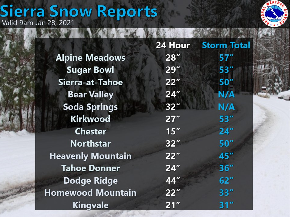
Tremendous snowfall amounts have occurred with the latest storm system in the Sierra Nevada Mountains of eastern California. Courtesy NOAA/NWS
From here, this low pressure system will likely head out into the Central Plains and then it should move northeast to near or right over the Ohio River on its way to a position over the state of Ohio by later Sunday – and this will likely be its most northward extent. Accumulating snow will fall to the north of this storm track this weekend as it moves from the Central Plains to the Ohio Valley with 6+ inches possible in many spots from Nebraska to Ohio. This upcoming snowfall will be in much of the same part of the country that experienced significant snowfall earlier in the week.

00Z GEM surface forecast map for Sunday evening with snow in much of the I-95 corridor during “phase 1” of the upcoming winter storm for the Mid-Atlantic/NE US. “Overrunning” precipitation on the front end will be followed by “coastal storm generated” precipitation on the back end or “phase 2” of this long duration event. Map courtesy Canadian Meteorological Centre, tropicaltidbits.com
On Sunday night and Monday, this initial or primary low pressure system over the Ohio Valley should weaken and give way to a developing storm near the Mid-Atlantic coastline and it is this secondary system that will become the dominant player. The exact timing of the transfer of energy from the initial low to the secondary system will play an important role as to how much snow (and/or rain/ice) can fall in the DC-to-Philly-to-NYC corridor as will the speed at which the coastal storm intensifies and its ultimate track. Shortly after the second storm takes a move from the Mid-Atlantic coastline, it will encounter a strong blocking pattern in the upper part of the atmosphere over eastern Canada and this will grind it to a halt. As a result, we are likely to be dealing with a long duration event in the Mid-Atlantic/NE US early next week.
It does appear increasingly likely that accumulating snow is a real threat in the Mid-Atlantic region during the initial “warm air advection” or “overrunning” phase of the storm from Sunday into Sunday night. The second phase of the storm will be associated with “coastal storm generated” precipitation and this can be for an extended period of time from Monday into Tuesday. “Wrap around” snow or snow showers are likely in the I-95 corridor in this Monday/Tuesday time period as the storm stalls out and perhaps even retrogrades a bit back towards the coast. There is certainly a chance that some areas in the I-95 corridor see a changeover from snow to a wintry mix during this event; especially, in the Sunday night/early Monday time frame. However, an influx of colder air on the back side of the coastal storm would likely result in a changeover back to all snow in those areas that do indeed turn to a wintry mix earlier in the event.

The latest ensemble run of the European model depicts significant snowfall in the Mid-Atlantic/NE US from the upcoming early week winter storm. Map courtesy ECMWF, Weather Bell Analytics
Stay tuned…lots of details to be ironed out in coming days for this complex and potentially significant winter storm for the Mid-Atlantic/NE US.
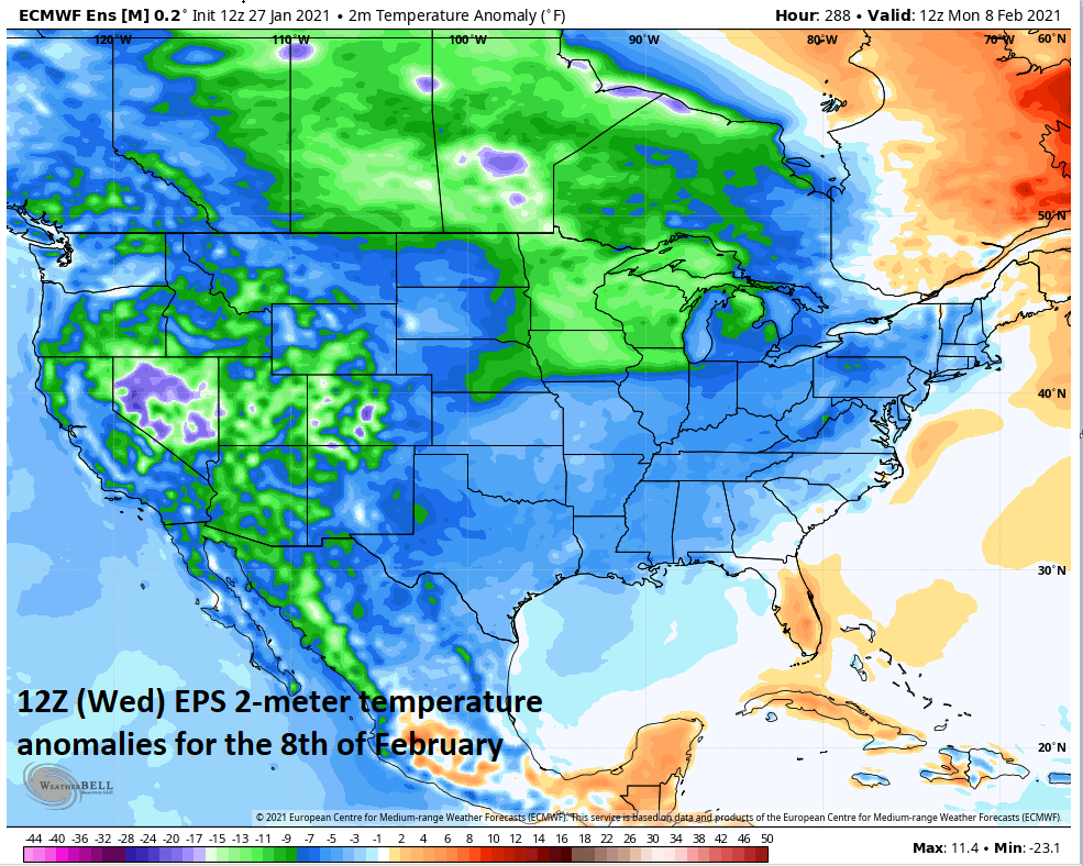
There are some signs for colder-than-normal conditions in much of the nation as we progress to the second week of February. This type of pattern is supported by teleconnection indices such as the NAO, AO ad MJO as well as by the prospects of another stratospheric warming event. Map courtesy Weather Bell Analytics, ECMWF
Looking ahead past the storm
There are some signals that the month of February could turn out to be quite interesting indeed with multiple anomalously cold air masses to deal with in the US and across Europe. One of the hints for this comes from an expected stratospheric warming event in coming days that will likely cause a disruption in the polar vortex - possibly resulting in some very cold air to drop from high latitudes to the northern US by the second week of February or so.

A forecast of 2-meter temperature anomalies as of 8 February shows some abnormally cold air across Europe and much of the US and Canada. Map courtesy Wxcharts.com
Another signal comes from a tropical disturbance known as the Madden-Julian Oscillation or MJO. There are model forecasts that depict that this particular teleconnection index may enter into what is called “phase 8” which happens to be a cold phase for much of the northern US during this time of year. Computer forecast models are now picking up on some awfully cold air for much of the US (and Europe) as we get into the second week of February….stay tuned on this possibility in coming days.
Meteorologist Paul Dorian
Perspecta, Inc.
perspectaweather.com
Follow us on Facebook, Twitter, YouTube
Video discussion: