11:30 AM | *Buckle up, it could be a wild ride*
Paul Dorian
Discussion
Overview This work week will be rather uneventful weather-wise with no big storms and nothing more than a warm frontal passage on Tuesday and a cold frontal passage on Wednesday. The upcoming weekend, however, will bring the threat for a coastal storm to the Mid-Atlantic region and there are numerous signs in the atmosphere and oceans around the world that this potential weekend event may be the beginning of an overall pattern change to “stormy and cold” – not only for the remainder of December, but perhaps right into the New Year as well.
500 mb pattern The overall wind flow in the upper part of the atmosphere around 500 millibars (~18,000 feet) during the next couple of days will be rather zonal (west-to-east) in the northeastern US and this will prevent any significant cold air outbreaks from Canada. Over the next 7-10 days, however, there will be a change to the upper-level wind flow with troughiness developing over the Aleutian Islands (blue area on forecast map below) and high pressure ridging forming along the west coast of the US and British Columbia (red area on forecast map below) [an increasingly +PNA and -EPO pattern]. This type of upper level pattern will increase the chances for Arctic air outbreaks to be able to drop from northern Canada into the northern US as we progress through the rest of December and into January.
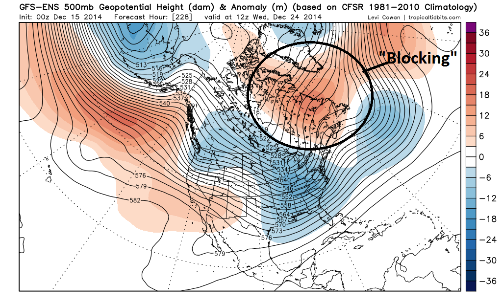 [00Z GFS-Ensemble 500 mb height anomaly forecast for Christmas Eve (12/24); map courtesy "tropicaltidbits.com"]
High-latitude blocking In addition, upper-level high pressure ridging is likely to develop over eastern Canada, Greenland and the western Atlantic (circled area above) in the next 7-10 days and this generally leads to a “blocking” pattern in the higher-latitudes which often favors colder and stormier weather in the Northeast US. The change to a “blocking” type of pattern can be tracked by the North Atlantic Oscillation (NAO) and Arctic Oscillation (AO) indices which - when negative - usually suggest some “blocking” in the atmosphere at higher latitudes is underway. Indeed, the NAO and AO are forecasted to drop sharply in the next 7-10 days or so into negative territory (red, circled areas on forecast maps below).
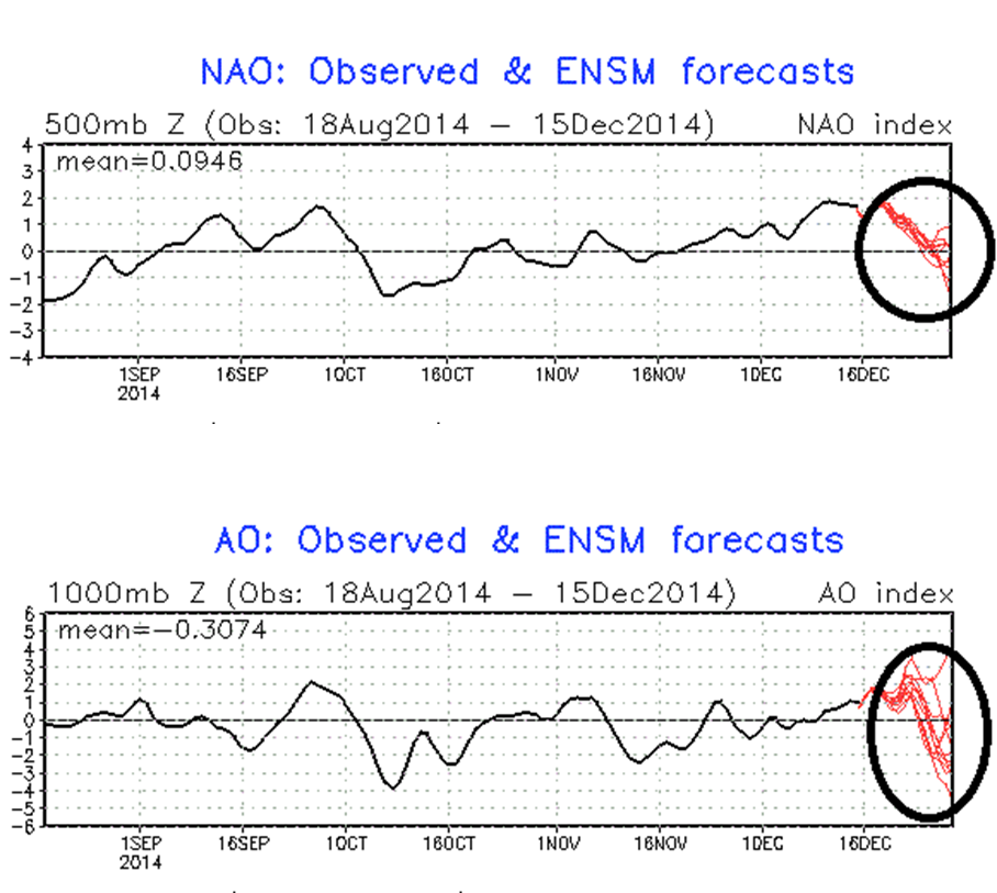 [North Atlantic Oscillation index and Arctic Oscillation index forecasts; courtesy NOAA]
An active southern jet Elsewhere, the sea surface temperature (SST) anomaly pattern in the Pacific Ocean currently features colder-than-normal water (blue area) to the north of Hawaii and warmer-than-normal water (yellow, orange area) near Hawaii and this combined with the unfolding weak El Nino (circled area) in the central tropical Pacific Ocean will likely generate an active southern jet stream cutting from west-to-east across the Pacific Ocean (indicated by arrow) and right into the southern US. This type of pattern will likely keep multiple storms coming into California over the next several days and these disturbances will tend to move west-to-east across the country riding along the southern jet stream.
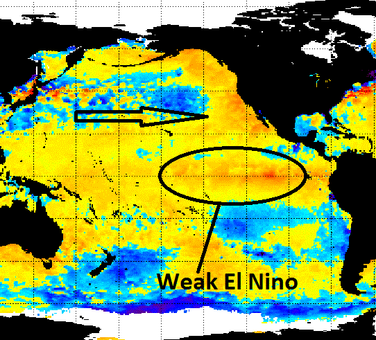 [Current sea surface temperature anomalies; courtesy NOAA]
Multiple storm threats There is the potential for storm development this weekend along the east coast from a system that will hit California on Tuesday, then head to Texas by mid-week, and then pull out of the southern states late in the week and make a move to the northeast. Computer forecast models are not in agreement with this potential threat – par for the course when several days out from any potential event – but the changes in the overall weather pattern as described above suggest that the threat is real. The air mass in place ahead of this potential weekend storm will be only marginally cold enough for snow in the Mid-Atlantic region so odds would probably favor rain at the coast and snow in interior higher-elevation locations with the I-95 corridor in the usual precipitation-type "battle zone" area. This storm may be the first of many over the next couple of weeks. A second storm is possible around the middle of next week and then another one a few days after that.
High-latitude “blocking”, a weak and centrally-based El Nino, and an active southern jet were all major factors in the 2014-2015 Vencore Weather Winter Outlook which favored a colder and snowier winter than normal: http://vencoreweather.com/2014-2015-winter-outlook/
Buckle up, it could be a wild ride.