12:10 PM | The collapse of El Nino continues
Paul Dorian

Collection of computer forecast models that generally predict current El Nino conditions will flip to La Nina by later this year; courtesy NOAA
Overview
The collapse of El Nino in the tropical Pacific Ocean continued during the month of February and it should be rather dramatic over the next few months. This current strong El Nino event reached its peak intensity level during December 2015 and all indications are that it will completely flip to La Nina conditions by later this year. This naturally occurring oceanic cycle that produces warmer-than-normal sea surface temperatures (SSTs) in the equatorial region of the Pacific Ocean began in earnest early in 2015 and strengthened throughout the year to comparable intensity levels of the strong El Nino episodes of 1982-1983 and 1997-1998. El Nino has had widespread consequences around the world and will continue to do so in the near future even though weakening will likely continue at a rapid pace. By later this year, colder-than-normal sea surface temperatures are quite likely to appear in the tropical Pacific Ocean as predicted by multiple computer forecast models and this flip to La Nina will also have extensive consequences around the world.

Upper-ocean temperature anomalies decreased sharply during February in the tropical Pacific Ocean; courtesy NOAA
Rapidly changing SST anomalies
The latest sea surface temperature anomalies show a noticeable decrease in February across the central and eastern equatorial Pacific Ocean. In addition, sub-surface temperature anomalies in the tropical Pacific Ocean also decreased substantially (circled area above) strongly suggesting the overall collapse of El Nino will continue in the near future.
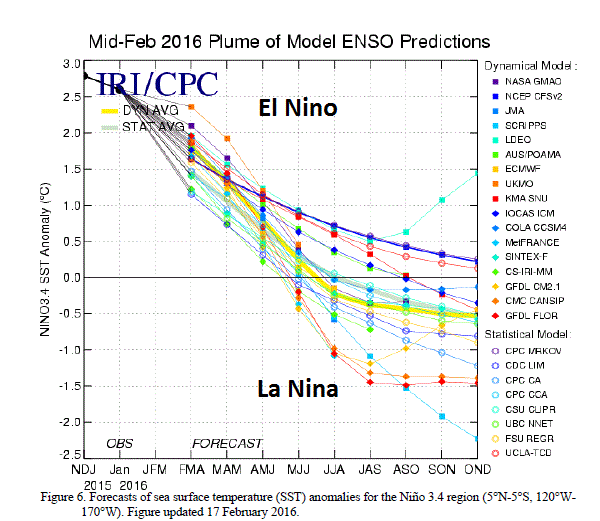
Computer model forecasts suggest a dramatic flip to La Nina
Numerous independently-made computer forecast models (from mid-February) depict a dramatic change in sea surface temperature anomalies in the tropical Pacific Ocean between now and late 2016 (top). A transition to “ENSO-neutral” is likely according to these models during the late Northern Hemisphere spring or early summer 2016, and La Nina conditions are quite likely to develop by the fall.

Global (black) and tropical (red) temperature anomalies since 2014; map courtesy Dr. Ryan Maue and Weather Bell Analytics
Consequences of La Nina
One of the important consequences of the current strong El Nino event in the equatorial Pacific Ocean has been a spike in global temperatures. The 2-meter temperature anomaly plot (above) shows the trend in global (black) and tropical (red) temperature anomalies since 2014 as measured by NOAA’s CFSR CDAS dataset. Tropical and global temperatures began to increase dramatically during the spring season of 2015 when El Nino began to strengthen significantly. In prior El Nino events during the past decade (e.g., 2006-2007, 2009-2010), there were indeed similar spikes in global temperatures and in each of these cases those temperatures dropped sharply after La Nina conditions became well-established in the tropical Pacific Ocean (below). Global temperatures will likely continue to stay at above-normal levels in the near term despite the fact that El Nino has passed its peak intensity level as tropical Pacific Ocean sea surface temperatures should remain above-normal for awhile longer. However, if recent history is any guide, expect global temperatures to drop sharply after La Nina conditions become well-established in the tropical Pacific Ocean.
As far as the Mid-Atlantic region is concerned, a transition from El Nino to La Nina might just result in a hotter and drier summer compared to normal which is typical of analog years. Also, the tropical season in the Atlantic Basin could actually be more active than in recent years as the "beneficial" effect of El Nino on the inhibition of tropical storm formation in the Atlantic Ocean (adds to wind shear) is likely to fade away with the demise of the El Nino. More on all of this comes later in the spring with the still progressing "2016 Summer and Tropical Outlook".

Global temperature anomalies from 2005 to 2016 with El Nino spikes and post-El Nino sharp drop offs; map courtesy Dr. Ryan Maue and Weather Bell Analytics
Meteorologist Paul Dorian
Vencore, Inc.