7:30 PM | *“Atmospheric blow torch” (Northeast US, Mid-Atlantic) and “atmospheric fire hose” (South-Central US, California)*
Paul Dorian

12Z GFS Ensemble forecast map of 500 mb height anomalies for Thursday morning; map courtesy tropicaltidbits.com
Overview
The 12Z GFS Ensemble forecast map of 500 millibar height anomalies for Thursday morning (above) shows three major players across the North American playing field in terms of upper atmosphere lows (blues) and highs (oranges). To begin, a strong upper level high will be situated over the Northeast US. This relatively slow moving system contributed to “atmospheric blow torch” conditions on Wednesday in the Northeast US and Mid-Atlantic region and there will many more records broken on Thursday as well in this part of the country. Elsewhere, one strong upper level low will be sitting over Mexico and another will be located over the northeastern Pacific Ocean. These two systems have already contributed to an “atmospheric fire hose” feeding copious amounts of moisture into both California and the south-central US (e.g., Louisiana, Arkansas). In addition, the strong upper low spinning over Mexico is associated with an air mass that is nearly 30 degree below normal for this time of year and this is resulting in many higher elevation locations receiving highly unusual snowfall amounts.

As of 4PM Wednesday, there were numerous broken high temperature daily records (in red) and many tied daily records (in orange); map courtesy coolwx.com
"Atmospheric blow torch" (Northeast US, Mid-Atlantic)
Temperatures were some 30 degrees above normal on Wednesday across the Northeast US and Mid-Atlantic region and record highs were reached in many spots ("record breaker" map above). For example, in the I-95 corridor from DC-to-Philly-to-NYC, record highs were reached on Wednesday afternoon at Philly Airport (82°), Dulles Airport (82°), BWI Airport (82°) and in Central Park, New York (77°) [Reagan National Airport in DC fell one degree short]. Many more records will fall on Thursday afternoon in the Mid-Atlantic region, but somewhat cooler conditions are coming for Friday and the upcoming weekend. A weak cool front is likely to set off some shower activity in the overnight hours and high pressure from the Midwest will bring temperatures down to more reasonable levels on Friday and Saturday albeit still above-normal for this time of year.

NOAA's 5-day total precipitation forecast map produced late Wednesday afternoon
"Atmospheric fire hose" (south-central US and California)
The same North American upper-level pattern that is contributing to record warmth in the Northeast US and Mid-Atlantic region is playing a role in excessive rainfall across much of California and the south-central US where a serious flooding event is unfolding. Substantial snow has also piled up across the higher elevation peaks of the Sierra Mountains with as much as five feet during the past several days. The deep upper-level low located off the Pacific Northwest coastline is producing a strong westerly flow of moist air from the Pacific Ocean into California. In fact, the origin of this river of moisture flowing into California is in the vicinity of Hawaii and gets its nickname of the “pineapple express” for that very reason.
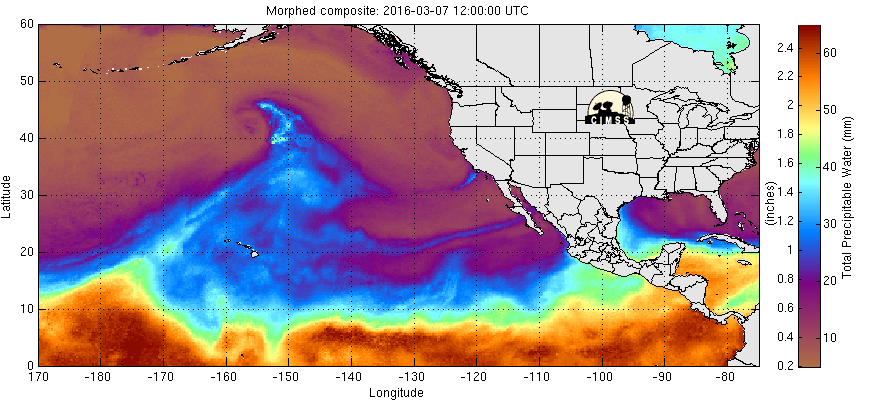
Meanwhile, counter-clockwise winds around the deep upper-level low situated over Mexico is producing a strong southerly flow of moist air into the south-central US (see loop below). In fact, not only is moisture streaming into the south-central US from the Gulf of Mexico, but Pacific Ocean moisture is feeding in as well from areas west of Mexico.

Derived precipitable water loop shows massive push of moisture into south-central US; courtesy University of Wisconsin/SSEC)
Both of these regions - California and the south-central US – can receive an additional foot of rain over the next several days on top of what has already fallen which has been quite significant. The Sierra Mountains are likely to receive another two or three feet of snow by the end of the upcoming weekend. The NOAA forecast map of precipitation amounts over the next five days (above) suggests a foot of rain can fall in that time period across northern California and southeastern Louisiana. The grounds are already pretty well saturated in both regions which increases the risk of flooding over the next five days or so.
Meteorologist Paul Dorian
Vencore, Inc.