9:50 AM | *El Nino continues to sputter and this could have important implications*
Paul Dorian

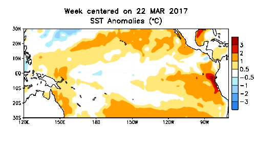
Sea surface temperature (SST) anomalies from late March to last week. Earlier this year, SST anomalies were showing up as well above normal (red) just off the west coast of South America, but recent days have shown closer-to-normal levels. Data courtesy NOAA/CPC
Overview
A weak El Nino instead of a moderate-to-strong one would allow for a more active tropical season in the Atlantic Basin. In addition, should a weak El Nino persist into the upcoming winter season and be concentrated in the central tropical Pacific Ocean (Modoki), it could increase the chances for a snowy winter in the eastern US. Earlier this year, it looked as though a moderate-to-strong El Nino was a sure bet as sea surface temperatures shot up to well above normal levels just off the west coast of South America. In addition, numerous computer forecast models at that time supported the idea of a moderate-to-strong El Nino in the tropical Pacific for the summer and fall seasons. Recent actual observations, however, indicate El Nino is sputtering and many computer forecast models have now backed away from a moderate-to-strong El Nino and this potential change could indeed have some important implications.

European model forecast from May for SST anomalies for the remainder of 2017 in the central Pacific Ocean (blue line represents mean); courtesy Weather Bell Analytics/Dr. Ryan Maue
Computer forecast models
Earlier this year, the vast majority of computer forecast models were predicting moderate-to-strong El Nino conditions in the tropical Pacific Ocean for the summer and fall seasons. However, these model forecasts have trended away from this notion as we slide towards the summer season and have in recent days shown a higher probability for weak El Nino. The European forecast model, for example, has shown a dramatic weakening of its El Nino outlook in just the last month. In May, the average SST anomaly predicted by the European computer forecast model for the central Pacific Ocean (a.k.a., region 3.4) was around +1.0 degrees (blue line, above) while the latest forecast (below) from early June is down to a considerably weaker near +0.5 degrees.
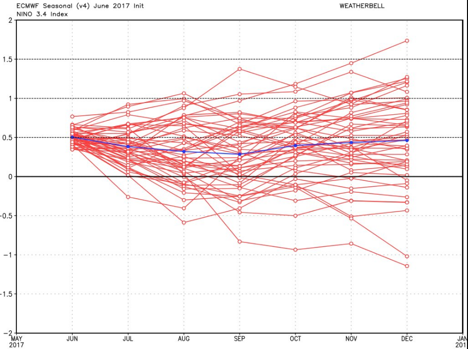
European model forecast from June for SST anomalies for the remainder of 2017 in the central Pacific Ocean (blue line represents mean); courtesy Weather Bell Analytics/Dr. Ryan Maue
Southern Oscillation Index (SOI)
One way meteorologists monitor the prospects of an El Nino (warmer-than-normal) or La Nina (colder-than-normal) in the tropical Pacific Ocean is by using an index known as the Southern Oscillation (SOI). The SOI is calculated using the pressure differences between Tahiti and Darwin. Sustained negative values of the SOI lower than −7 often indicate El Niño episodes. These negative values are usually accompanied by a decrease in the strength of the Pacific trade winds and sustained warming of the central and eastern tropical Pacific Ocean. Sustained positive values of the SOI greater than +7 are typical of a La Niña episode. They are associated with stronger Pacific trade winds and warmer sea temperatures to the north of Australia. Waters in the central and eastern tropical Pacific Ocean usually become cooler during this time. In fact, the SOI has averaged +0.12 for the last 30 days which is not a favorable signal for El Nino. During the last 90 days, the SOI has been in negative territory (-2.65); however, still below the usual favorable territory for indicating an El Nino. [Data source]
Potential consequences of a weak El Nino
One of the reasons it is important to monitor SST changes in the tropical Pacific Ocean is the fact that it can have an important consequence on the Atlantic Basin tropical season. In an El Nino year, there is a tendency for less tropical activity in the Atlantic Basin as El Nino-induced vertical wind shear is typically higher-than-normal and this tends to inhibit the development or intensification of tropical storms. A strong El Nino is often correlated with quieter-than-normal tropical activity in the Atlantic Basin; however, a weak El Nino could allow for a more active season – and those prospects are now growing. Of course, there are other factors that also play a role in the Atlantic Basin tropical season such as sea surface temperature anomalies.
In addition to its impact on tropical weather in the Atlantic Basin during the summer and fall, El Nino can have an impact on temperatures and snowfall in the eastern US during the winter season. For example, a strong El Nino that is concentrated in the eastern tropical Pacific Ocean can flood the eastern US with warmer-than-normal air during a winter season. If, however, there is a weak El Nino that is centered over the central tropical Pacific Ocean – and these prospects are increasing – the winter could turn out to feature more snow than normal in the eastern US. Weak El Nino conditions in that location tends to activate the southern branch of the jet stream which is bullish for east coast storms and it typically does not overwhelm the eastern US with warmer-than-normal air.
Stay tuned.
Meteorologist Paul Dorian
Vencore, Inc.
vencoreweather.com