
8:30 AM (Saturday) | ***Dangerous Hurricane Irma to head over the Lower Keys on Sunday and towards the western side of Florida - and likely intensify dramatically before landfall***
Paul Dorian
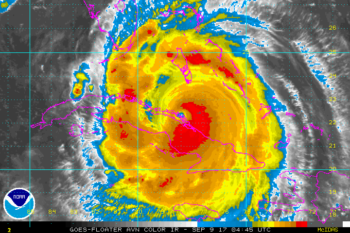
The latest colorized IR satellite loop with Irma's center moving along the northern coast of Cuba; courtesy NOAA/GOES
Sat AM update: Irma slammed ashore in northern Cuba last night as a category 5 hurricane – the first such there since 1924. Irma weakened slightly in the overnight hours, but is likely to strengthen again tonight and Sunday before making landfall possibly on the southwest side of Florida after moving over the Lower Keys - perhaps right over Key West. Exact landfall on the Florida peninsula is quite difficult to pinpoint at this time, but there is a chance it ends up somewhere between Naples and Port Charlotte as a category 4 or 5 hurricane. Computer forecast models such as NOAA's GFS have been rather consistently predicting a rapid intensification of Irma in the hours before making landfall.

The latest official track for Hurricane Irma from NOAA's National Hurricane Center.
At 8am, Irma featured 130 max sustained winds, movement to the WNW at 12 mph and a central pressure reading of 937 mb. During the next several hours, Irma may continue to weaken slightly - perhaps to category 3 status - as it continues to interact with the northern coast of Cuba, but once back out over the open waters of the Florida Straits, Irma is quite likely to undergo some rapid intensification from later tonight into Sunday – perhaps even in a dramatic and significant fashion.
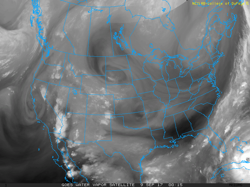
The latest water vapor imagery loop indicating winds in the upper atmosphere are now out of the southwest over much of Florida and this will allow Irma to turn more to the north-northwest beginning tonight; courtesy NOAA/College of DuPage
The latest water vapor imagery loop indicates winds in the upper atmosphere are now pushing from southwest-to-northeast from Florida to the western Atlantic and this action will allow Irma to make a turn from its current west-to-northwest track to one that is more north-to-northwest by Sunday. This turn will be the result of Irma moving to the southwestern side of a subtropical ridge that will weaken as an upper-level trough pushes into the Southeast US. In addition to the change in the direction of Irma, this southwesterly flow in the upper part of the atmosphere will most likely allow for some intensification later tonight and on Sunday as it’ll improve the outflow above the circulation center which is favorable for strengthening. Also, sea surface temperatures are very warm in the area between northern Cuba and southern Florida as well as off the west coast of Florida and this is also favorable for intensification. Movement over land and strong shear will cause steady weakening of Irma late Sunday and Monday.

Storm tracks for Irma as predicted by the many ensemble members of the 00Z Saturday Euro computer forecast model; map courtesy Weather Bell Analytics
Virtually the entire state of Florida could experience hurricane conditions later this weekend, but the worst case scenario is now setting up for Lower Keys and western and central sections of the state with the latest expected path paralleling the west coast of the Florida peninsula. Once past Florida, Irma will eventually turn northwestward pushing through southwestern Georgia and towards the Tennessee Valley and weakening along the way.
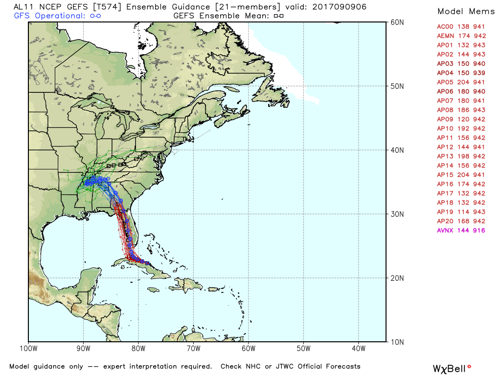
Storm tracks for Irma as predicted by the many ensemble members of the 00Z Saturday GFS computer forecast model. The GFS model has consistently predicted rapid intensification of Irma just before making landfall. ; map courtesy Weather Bell Analytics, NOAA/EMC
One final note, Hurricane Jose is following Irma in the Atlantic and is now a category 4 storm. It may be a serious concern for the east coast in a week to ten days.
Meteorologist Paul Dorian
Vencore, Inc.
vencoreweather.com