
11:00 AM | *Unfolding stratospheric warming event signaling more frigid air is likely in store for the central and eastern US*
Paul Dorian

Temperature anomalies over the past 30 days (November 10-December 9) at 10 mb (i.e., stratosphere) with a major warmup showing up in recent days across the high latitudes; courtesy NOAA
Overview
One of the ways to monitor the potential for wintertime Arctic air outbreaks in the central and eastern U.S. is to follow what is happening in the stratosphere over the Northern Hemisphere. Sudden Stratospheric Warmings (SSWs) are large, rapid temperature rises in the winter polar stratosphere, occurring primarily in the Northern Hemisphere, and these events have been found to set off a chain of events in the atmosphere that ultimately can lead to polar vortex disruptions and Arctic air outbreaks for the central and eastern US. Indeed, there is a significant stratospheric warming event now unfolding and it raises the chances for more frigid weather during the middle and latter stages of January.

Model forecast map for late December of 10 mb (i.e., stratosphere) temperature anomalies with a large area of warming sandwiched in between two areas with colder-than-normal conditions; map courtesy Weather Bell Analytics, NOAA
Discussion
The stratosphere is the second major layer of the atmosphere just above the troposphere and below the mesosphere. It occupies the region of atmosphere from about 12 to 50 km, although its lower boundary tends to be higher nearer the equator and lower nearer the poles. The stratosphere defines a layer in which temperatures rise with increasing altitude. At the top of the stratosphere, the thin air may attain temperatures close to 0°C. This rise in temperature is caused by the absorption of ultraviolet (UV) radiation from the sun by the ozone layer. Such a temperature profile creates very stable atmospheric conditions and the stratosphere lacks the air turbulence that is so prevalent in the troposphere. Consequently, the stratosphere is almost completely free of clouds or other forms of weather.
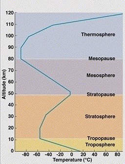
Layers of the atmosphere from the surface (ground) level to 120 km
Sudden stratospheric warmings (SSWs) are among the most impressive dynamical events in the physical climate system. During the winter months in the polar stratosphere, temperatures are typically lower than minus 70°C. The cold temperatures are combined with strong westerly winds that form the southern boundary of the stratospheric polar vortex which plays a major role in determining how much Arctic air spills southward toward the mid-latitudes. This dominant structure is sometimes disrupted in some winters by being displaced, split apart or even reversed. Under these circumstances, the winds can decrease or change directions and the temperatures in the lower stratosphere can rise by more than 50°C in just a few days.
In response to the stratospheric warming (and associated layer expansion) at the high latitudes, the troposphere cools down dramatically (with layer contraction) at the high latitudes. This tropospheric cold air can then be transported from the high latitudes to the middle latitudes given the right overall weather pattern (e.g., "high-latitude blocking" over Greenland/northern Canada). The tropospheric response to the SSWs closely resembles the negative phase of the North Atlantic Oscillation (NAO), involving an equatorward shift of the North Atlantic storm track; extreme cold air outbreaks in parts of North America, northern Eurasia and Siberia; and strong warming of Greenland, eastern Canada, and southern Eurasia (Thompson et al., 2002).
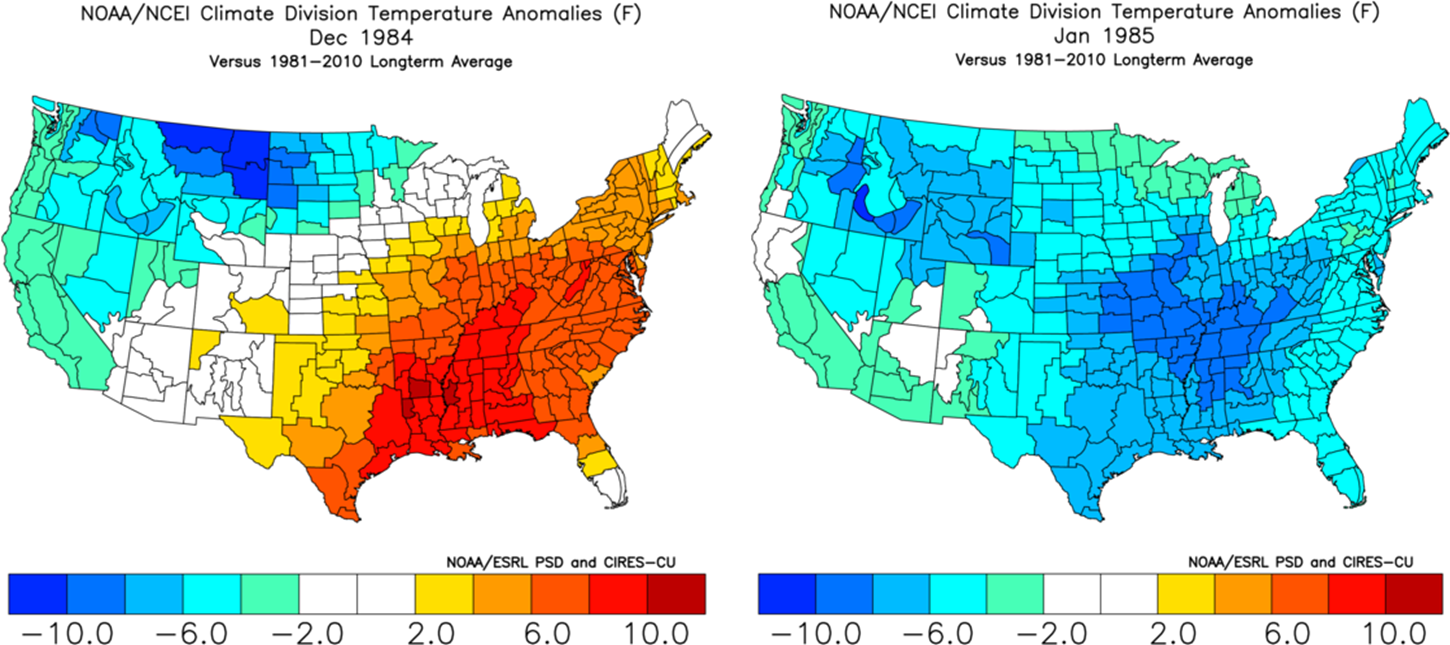
Stratospheric warming events can take several weeks to unfold between the time the warming first appears in the stratosphere near the pole and the time the cold air outbreaks reach the middle latitudes. In fact, there are examples in which extended significant warm ups took place before the “stratospheric warming induced” cool down (temperature anomalies December 1984, left; January 1985, right). Courtesy NOAA
The entire process from the initial warming of the stratospheric at high latitudes to the cooling in the troposphere at middle latitudes can take several weeks to unfold. In fact, it is not at all unusual for an extended significant warm up to take place before the “stratospheric warming induced” cool down takes hold (e.g., December 1984 (warm), January 1985 (cold)). It is still too early to say exactly where this unfolding stratospheric warming event may result in some extreme cold, but if past history is any guide, it could be in the central and eastern US during the month of January.

Stratospheric temperature anomalies during January 1985 with much above-normal temperatures on this side of the North Pole. This map has a "top-down" view of the Northern Hemisphere with the North Pole located right in the center and the US is positioned in the lower-central portion. Courtesy NOAA
The 1984/1985 Stratosphere Warming Event
Some stratospheric warming events in recent history have, in fact, been followed by widespread very cold air outbreaks across the central and eastern US - usually some two to three weeks after the initial upper atmosphere warming. For example, a major SSW event began in December 1984 and continued into early January of 1985 and this was followed by a period of extreme cold in the central and eastern US during the latter half of January 1985. In fact, it turned out to be so cold for Ronald Reagan’s second inauguration on January 20th, 1985 that all outdoor activities for that day were moved inside to protect the public. Interestingly, the month of December in 1984 actually was warmer-than-normal in much of the eastern half of the nation.

Surface temperature anomaly pattern in the US during the latter part of January 1985 following a major stratospheric warming event; map courtesy NOAA
A detailed video discussion on the phenomenon of “Stratospheric Warming” and the 1984/1985 stratosphere warming event can be found on our "Meteorology 101" page.
Meteorologist Paul Dorian
Perspecta, Inc.
perspectaweather.com