
1:15 PM | **Powerhouse storm in nation’s midsection at mid-week**
Paul Dorian

Surface pressure of the unfolding mid-week monster storm system could reach record (low) levels and strong winds in the lower atmosphere are likely to result in surface wind gusts of hurricane-force; courtesy NOAA/EMC, tropicaltidbits.com
Overview
All the ingredients are coming together for a powerful storm system to be located in the middle of the country at mid-week. This storm will have wide ranging impacts from heavy snow to its north and west and potential severe weather in its warm sector to the south and east of the low pressure center along with hurricane-force winds. The central pressure of this storm system is likely to bottom out near 972 mb (28.70 inches) late Wednesday which could very well set some low pressure records in that part of the country.

The warm sector of this mid-week storm will feature much warmer-than-normal conditions and potential severe weather while the cold sector will feature heavy snowfall and colder-than-normal weather; courtesy NOAA/EMC, tropicaltidbits.com
Details
Very vigorous energy in the upper part of the atmosphere will pull out of the Southwest US at mid-week and help to set off the rapid intensification of low pressure which will head into the central Plains. The perfect combination of a negatively-tilted deep trough in the upper atmosphere, intense temperature gradient in the lower levels, and multiple strong jet streaks in the atmosphere will help to generate a powerful mid-week storm system in the nation’s heartland. One forecast model actually predicts an “eye” may form at the center of the low pressure system sometime late Wednesday or Wednesday night - similar to what is seen with Atlantic Basin hurricanes.
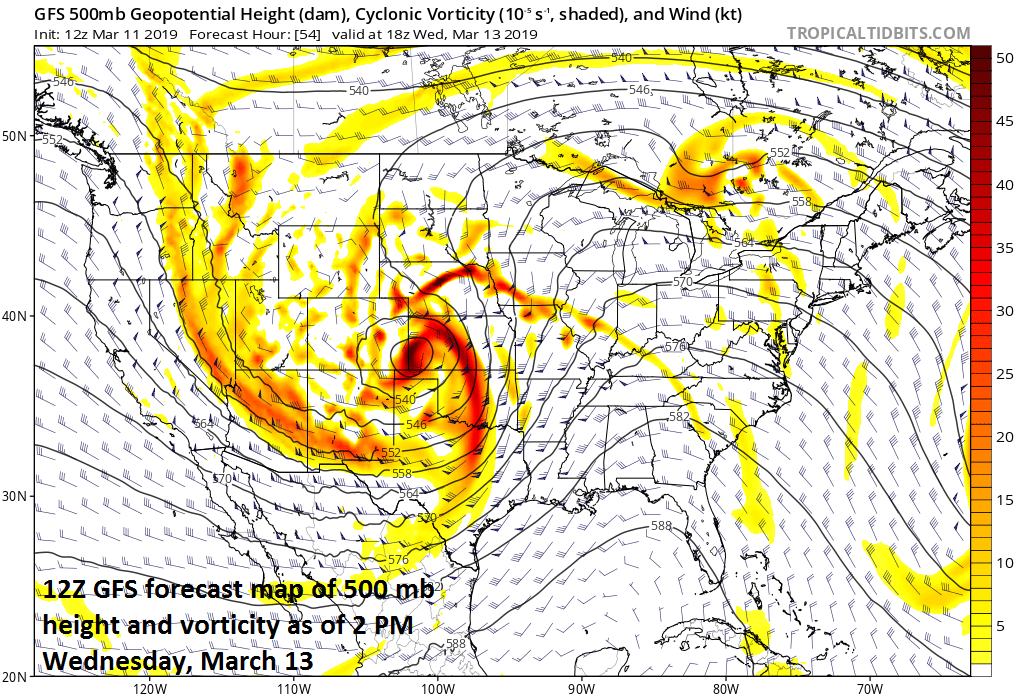
Very vigorous energy in the upper atmosphere will be a key player in the formation of this strong storm system; courtesy NOAA/EMC, tropicaltidbits.com
In the cold sector, heavy snow is likely to be deposited over the next few days first in the Southwest US then the Colorado Rockies and finally to the Northern Plains - more than a foot of snow can fall in some of these locations. In the warm sector, given the anticipated intensity of upper-level jet streaks and the central barometric pressure of the surface low, ground-level winds can easily gust to hurricane-force levels all the way from eastern New Mexico/western Texas to the central Plains. Severe weather is certainly on the table across the central and southern Plains given the dynamics of this unfolding mid-week powerhouse.

The powerhouse storm system may develop an “eye” late Wednesday in much the same manner as a hurricane; courtesy ECMWF, weathermodels.com (Dr. Ryan Maue, twitter)
Later in the week, as the storm heads towards the Great Lakes it will pass through its most intense phase and tend to “fill” as the upper level wave of energy “shears out”. Nonetheless, this system will drag a strong cold front into the eastern states late in the week and milder air will flow northward into the Mid-Atlantic region in the hours prior to its arrival. In fact, temperatures should reach the 60’s in the I-95 corridor on Friday just ahead of the cold frontal system and showers are quite likely as well. Colder air will follow the late week frontal passage for the upcoming weekend and the early part of next week and will begin a likely colder-than-normal stretch of weather for the Mid-Atlantic region during the last couple weeks of March.
Meteorologist Paul Dorian
Perspecta, Inc.
perspectaweather.com