
12:25 PM | *The tropical scene remains active in the Atlantic Basin as we enter the climatological peak time period of the season*
Paul Dorian
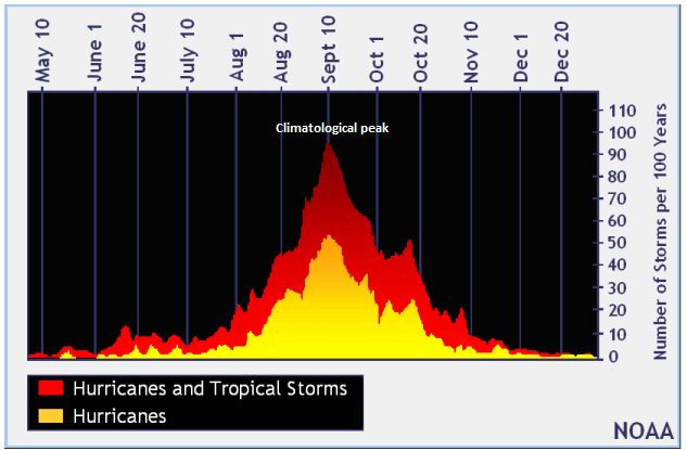
The climatological peak of the Atlantic Basin tropical season falls right around the 10th of September according to NOAA’s look at the past 100 years.
Overview
The climatological peak of the Atlantic Basin tropical season is right around September 10th and it is adhering to history with not one, not two, but three different systems lined up in the tropical Atlantic and additional waves lurk over the Africa continent. The first wave is likely to move through the Florida Straits or over South Florida this weekend and it could strengthen into a tropical storm. Regardless of development, this system is liable to produce heavy rain and gusty winds in the Bahamas and Florida in coming days. The next system out in the central Atlantic is facing long odds of survival as it will encounter unfavorable wind shear in the near term. The third wave is currently far out in the eastern Atlantic and it poses a potential longer-term threat to the Bahamas, Florida and the rest of the Gulf of Mexico region as it will slowly trek across the tropical Atlantic in coming days and ultimately, it should find favorable atmospheric conditions for intensification.

This 5-day forecast map shows the predicted tracks of tropical systems now in the Atlantic Basin. One wave (#1) is expected to push into the Gulf of Mexico while another (#3) treks westward across the tropical Atlantic. A third wave (#2) is expected to fall apart in a few days.
Discussion
The Atlantic Basin tropical season has been relatively normal so far in terms of a few key parameters as we reach the climatological peak time period. Specifically, there have been 7 named storms through September 11th and the normal number is 6.7. There have been 2 observed hurricanes so far with one major and the normal amounts for these measures are 3 hurricanes and 1 major at this point in the tropical season (source Philip Klotzback, CSU). Currently, three waves are lined up in the tropical Atlantic and a few more are heading west across the African continent.

Strong high pressure ridging over southeaster Canada this time of year often results in tropical systems “sliding underneath” the ridge (arrow) towards the Bahamas, Florida and the rest of the Gulf of Mexico region. Courtesy NOAA, tropicaltidbits.com
The first wave that is closest to the US is likely to head W-NW over the next few days and push over the Florida Straits or South Florida and into the Gulf of Mexico. It may develop into a tropical storm this weekend and will likely produce some locally heavy rain and gusty winds in the Bahamas and Florida and ultimately could do the same in the northern Gulf coastal region early next week. Another wave is currently situated over the central Atlantic and it is facing long odds against survival as it moves into an area of high wind shear.

There are multiple disturbances over the continent of Africa which are likely to head west into the tropical Atlantic in coming days and these are likely to continue an active pattern through the latter stages of September. Courtesy CIMSS Wisconsin, NOAA
A third wave has just recently pushed off the west coast of Africa. This wave poses a longer-term threat as it will take several days for it to trek across the tropical Atlantic and towards the islands of the eastern Caribbean or Bahamas. The overall upper-level pattern will evolve into one that is quite favorable for tropical systems this time of year with strong high pressure ridging likely to set up across southeastern Canada in a week to ten days or so. Often times, with this kind of setup in the atmosphere this time of year, tropical systems can “slide underneath” the ridge and move towards the Bahamas, Florida and the rest of the Gulf of Mexico region. This system has the potential to do such in about ten days or so and will need to be closely monitored. Looking even farther ahead, with more waves now over the African continent, the Atlantic Basin tropical scene is likely to remain active as we progress towards the latter part of the month of September.
Meteorologist Paul Dorian
Perspecta, Inc.
perspectaweather.com
Video discussion: