
11:10 AM | *An update on tropical activity in the Atlantic Basin*
Paul Dorian
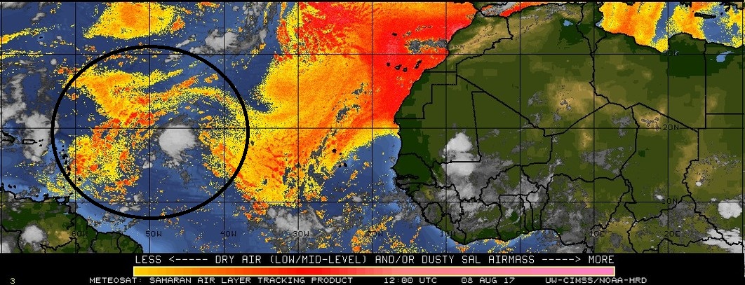
Dry air that has its origins over the Saharan Desert region of Africa is represented on this map by orange, red and yellow. Invest 99L will encounter some dry air (in circled region) over the next 48 hours and this will inhibit intensification. However, by the weekend, this tropical wave is likely to find somewhat more favorable atmospheric conditions over the western Atlantic and it will have to be monitored closely. Image courtesy University of Wisconsin/CIMSS
Overview
From a climatological point-of-view, it is now the time of year for the Atlantic Basin to start ramping up in terms of tropical activity and indeed that is happening right on schedule. Typically, tropical activity ramps up in the Atlantic Basin during the month of August, peaks around mid-September, and then gradually winds down during the fall months of October and November. Currently, there are two tropical systems of interest in the Atlantic Basin. Tropical Storm Franklin is headed today across the Yucatan Peninsula on its way to a likely landfall in northeastern Mexico in a couple of days. In addition, a tropical wave in the central tropical Atlantic known as “Invest 99L” will likely face some difficult environmental conditions during the next 48 hours, but it will then have to be closely monitored as it comes closer to the US east coast and reaches a more favorable atmosphere for intensification.

Atlantic Basin tropical activity tends to ramp up in August and peak in mid-September.
Tropical Storm Franklin
Tropical Storm Franklin has sustained winds at 45 mph and is currently moving WNW at about 14 mph. It is now moving over the Yucatan Peninsula region of Mexico and is likely to emerge over the Bay of Campeche later tonight where water temperatures are quite high for this time of year. There has been some weakening in Franklin in the past twelve hours or so as it moved over land and some more weakening is possible today; however, once the center moves back out over the warm waters of the Bay of Campeche restrengthening is likely to occur. In fact, I believe there is a chance that Franklin could strengthen to strong tropical storm or even hurricane status before it likely makes landfall in northeastern Mexico early Thursday morning.
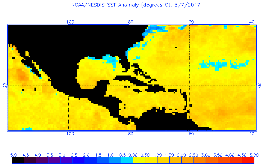
This map of current sea surface temperature anomalies shows a large area of warmer-than-normal water in the western Atlantic, Gulf of Mexico and Caribbean Sea (yellow, orange). This scenario is favorable for development or intensification of tropical systems. (map courtesy NOAA)
Invest 99L
A tropical wave known as “Invest 99L” is located some 800 miles east of the Lesser Antilles and it is currently generating a rather disorganized area of showers and thundershowers. This system will face some difficult environmental conditions over the next 48 hours or so inhibiting its chances for intensification. Specifically, this tropical wave will push through an area of rather dry air that pushed westward off the west coast of Africa in recent days and originating over the Saharan Desert of Africa. However, once this wave passes by that dry air mass, conditions are likely to become more favorable for strengthening and there is a chance that Invest 99L could become a tropical storm by the weekend as it heads to the western Atlantic.
Looking ahead, it certainly is within the realm of possibility that this tropical system reaches hurricane status at some point, but early signs favor a turn away from the US east coast before ever making landfall. However, that is too far away for any certainty and this system has to be closely monitored over the next several days.

High pressure ridging is pronounced across southeastern Canada and the northeast US at this forecasted time of August 21st (orange region). This type of setup is a "red flag" this time of year for potential impact on the US from tropical activity. (map courtesy tropical tidbits.com, NOAA)
Longer term prospects for tropical impacts in the US
Tropical Storm Franklin will avoid the US as it is quite likely to make landfall in northeastern Mexico later this week. Invest 99L has to be closely monitored over the next several days as it may strengthen this weekend over the western Atlantic after it passes through a dry air mass in the near term. In terms of a potential US landfall by Invest 99L, it is just too early to write it off, but odds favor a turn away before it ever reaches the coast.
Longer term, there are signs for abnormally strong high pressure ridging to develop over the southeastern part of Canada and Northeast US later in the month and this could present more of a problem for the US compared to what will take place in the near term. Strong high pressure situated in these particular regions this time of year raises a red flag as far as potential US impact is concerned with respect to tropical systems. There tends to be a greater chance for tropical systems to push all the way across the Atlantic and into the US when strong high pressure builds across southeastern Canada. Bottom line, tropical threats may actually become more of problem for the US during the last ten days or so of August.
Stay tuned.
Meteorologist Paul Dorian
Vencore, Inc.
vencoreweather.com
Detailed video discussion on the tropics: