7:10 AM | *Record snowfall in North America for the month of November*
Paul Dorian

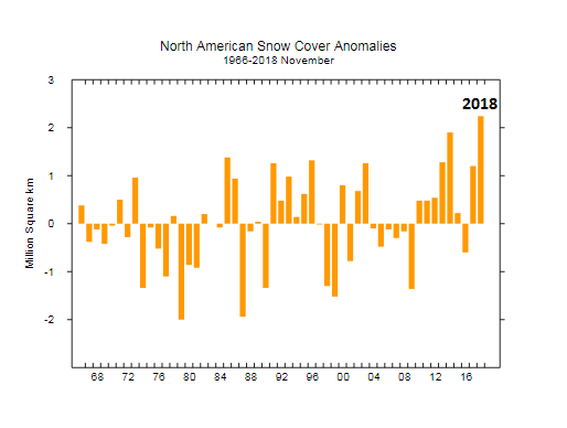
Snow cover anomalies for the month of November across “North America”; courtesy Rutgers Snow Lab
Overview
The month of December is well underway and there have already been some impressive snow accumulations for the month in such places as the Upper Midwest, western US and, most recently, in a large swath from Texas to North Carolina/Virginia with the very latest major winter storm. As it turned out, the month of November ended up with the most snowfall ever recorded in North America during the satellite era which goes back to the 1960’s. Unusual cold for the month from Mexico-to-US-to-Canada contributed to this snowfall record in North America. The November snowfall extent in the Northern Hemisphere was the third highest ever recorded in the satellite era and continues an upward trend in recent years.

Snow cover anomalies for the month of November across the “Northern Hemisphere”; courtesy Rutgers Snow Lab
Discussion
November’s average snow cover across North America was an estimated 5.24 million square miles, topping the previous November record of 5.11 million square miles set in 2014, according to data from the Rutgers University Global Snow Lab (GSL) dating all the way back to 1966. The US experienced cold and stormy weather and this resulted in some of the earliest snowfalls ever recorded in such places as Houston, Texas and Monroe, Louisiana. A major storm that impacted much of the I-95 corridor at mid-month resulted in New York City’s (Central Park) heaviest November calendar-day snow in 136 years and the earliest ever for a reading of 6 inches or more (6.4”) as well as a pair of days that failed to get above freezing (Thanksgiving Day and Black Friday). In addition, the 8.1 inches recorded in Allentown, Pennsylvania (Allentown Lehigh Valley Airport) was the heaviest November snowfall there since records began in 1944 (source EPAWA, twitter). The 1.4 inches of snow recorded at Reagan National Airport (DCA) in Washington, D.C. at mid-month was their first measurable November snow accumulation since 1996.
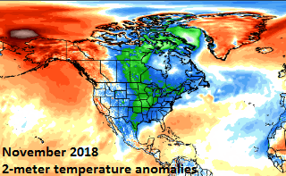
2-meter temperature anomalies for month of November 2018 across North America; courtesy Weather Bell Analytics
The last weekend of November featured a major snowstorm that pummeled the region from the central Plains to the Great Lakes and Chicago’s O’Hare Airport got off to its snowiest start to a winter season since the 1950’s with a foot of snow. In a typical year, it takes until the second week of January for O’Hare to receive that amount (according to weather.com). New England got hit very hard in late November with, for example, more than 19 inches recorded at Burlington, Vermont. Snow even returned to the state of California during the second half of November after an extensive dry spell ended with the onslaught of storms that moved in from the Pacific Ocean. Many spots in the Sierra Nevada Mountains ended up with 2 or 3 feet of snow in a late month storm that also produced heavy rainfall in coastal sections.

According to NOAA, November 2018 was the 27th coldest in the US going back to the late 1800’s with an average temperature of 40.08 deg (F) which was 1.61 deg (F) below the normal (using base period 1901-2000) and it was considerably colder than the last two Novembers.
In terms of cold, virtually all of the US and Canada experienced colder-than-normal conditions in November with the state of California and the western part of Canada the only exceptions. In fact, it was the 27th coldest November in the US going back to the late 1800’s according to NOAA. There were 2-meter temperature departures as much as 5 or 6 degrees (Celsius) below normal in a large swath from central Canada to the central US during this abnormally cold month. While Greenland was generally above normal in term of overall monthly temperatures during November, its snowfall was in the “normal” range when compared to the 1981-2010 base period.

Top: The total daily contribution to the surface mass balance from the entire ice sheet (blue line, Gt/day). Bottom: The accumulated surface mass balance from September 1st to now (blue line, Gt) and the season 2011-12 (red) which had very high summer melt in Greenland. For comparison, the mean curve from the period 1981-2010 is shown (dark grey). The same calendar day in each of the 30 years (in the period 1981-2010) will have its own value. These differences from year to year are illustrated by the light grey band. For each calendar day, however, the lowest and highest values of the 30 years have been left out.
Meteorologist Paul Dorian
Perspecta, Inc.
perspectaweather.com