
10:30 AM (Wed) | *****High impact storm for the Mid-Atl./NE US…sleet to become a big player in DC-to-Philly corridor…primarily a snow event for upstate PA, interior upstate NJ, NY, New England*****
Paul Dorian

This major winter storm will result in a variety of precipitation types across the Mid-Atlantic/Northeast US. Snow will dominate across upstate PA, interior upstate NJ, NY and New England whereas rain will dominate from southern NJ-to-the southern half of the Delmarva Peninsula-to-southeastern Virginia. A mixed precipitation event is likely along much of the I-95 corridor region with sleet becoming a major player. Map courtesy Weather Bell Analytics, NOAA
Overview
A high impact winter storm is getting underway in the Mid-Atlantic region and it will push into the Northeast US later today and continue into early Thursday. Sleet will become a big player in the DC-to-Philly corridor with freezing rain in the mix as well and this will limit total snowfall accumulation amounts. This storm will be primarily a snow event across upstate PA, interior upstate NJ, NY and New England and rain will dominate from southern NJ-to- the southern half of the Delmarva Peninsula-to-southeastern Virginia. Travel conditions will become quite difficult for the Wednesday PM and Thursday AM commutes from this major winter storm.

An Arctic high pressure system is anchored over southeastern Canada today and it is a key player in this high impact winter storm that is on the way for the Mid-Atlantic/Northeast US. Map courtesy NOAA
Details
Very strong and cold high pressure is anchored this morning across southeastern Canada today and it is funneling cold, dry air all the way down into the southern Mid-Atlantic region. Low pressure is starting to intensify along the Carolina coastline and it will move all the way to the Delmarva Peninsula by early tonight and then to the east of New Jersey by early Thursday. This low pressure system is tapping into a lot of moisture from the Gulf of Mexico and Atlantic Ocean and all of this moisture is headed right into the very cold and dry air mass entrenched over the northeastern quadrant of the nation.

Snow or a mix of snow and sleet will arrive in the DC metro region during the mid-to-late morning hours and then advance into Philly by early-to-mid afternoon and to NYC metro area during the late afternoon hours. As the low pressure system pushes northward towards the Delmarva Peninsula later today, counter-clockwise winds will push in slightly milder ocean air to the upper part of the atmosphere over the I-95 corridor. This push of milder air aloft will lead to a changeover of the snow to mixed precipitation in the DC-to-Philly corridor which will limit overall total snow accumulation amounts. In fact, sleet will become a big player in much of this region during this storm with a pelting of ice pellets on the table. Freezing rain is also going to be part of the mix in the DC-to-Philly corridor and as surface temperatures likely stay at or below freezing in most areas, there can be an ice build-up on untreated surfaces. In the NYC metro region, sleet can mix in early tonight, but snow is likely to be the main precipitation type for much of this winter storm.

As the low pressure system pushes to the east later tonight, colder air will wrap around and any mixed precipitation in the I-95 corridor is likely to change back to all snow and this late night snow can be heavy enough for additional accumulations; especially, in areas to the north of the PA/MD border. In areas well to the north and west of I-95, any mixed precipitation will be short in duration and snowfall accumulations can be considerably higher compared to the immediate metro areas. In fact, there can be a sharp gradient of snowfall amounts over a distance of just 25-50 miles or so from the metro regions to the far northern and western suburbs.

A couple of other notes, there is likely to be “mesoscale” or small-scale bands of heavy precipitation during this storm which can lead to intense snow (or sleet) at times in some areas. Also, it is not out of the question that some convective activity develops in parts of the Mid-Atlantic/Northeast US given the very strong wave of energy that will be moving overhead with “thunder snow” or “thunder sleet” on the table.
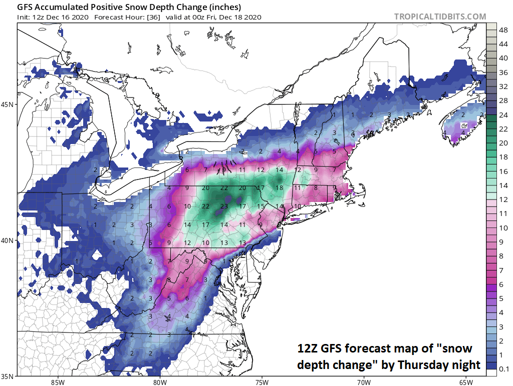
The latest 12Z GFS “snow depth change” forecast map is shown here for the mid-week event. “Snow depth” forecast maps may look quite different than the conventional “total snowfall amounts” forecast maps which do not take into account “melting” or “compacting”. For this type of storm, the “snow depth change” forecast map may be more informative than the “total snowfall amounts” map since icing will be quite significant in some areas (i.e. “compacting”). Map courtesy NOAA, tropicaltidbits.com
In addition to the snow and ice, winds will become quite a problem during the brunt of the storm with gusts possible of 40+ mph at inland locations and 50+ mph at coastal locations. This type of strong wind combined with accumulating ice and/or wet snow can certainly result in some power outages in the Mid-Atlantic region and Northeast US.
The latest snowfall estimates are as follows and this will be difficult to measure in many areas with the expected “compaction” of the snow by ice pellets/freezing rain:
DC: 1-3 inches in DC, 3-6 inches in the N/W suburbs
Philly: 4-8 inches in Philly, 6-12 inches in the N/W suburbs
NYC: 8-14 inches throughout the metro region

A cold blast is likely for the central and eastern US late next week…just in time for Christmas
One final note - and always looking ahead - looks like a cold blast for the central and eastern US late next week and just in time for Christmas Day.
Meteorologist Paul Dorian
Perspecta, Inc.
perspectaweather.com
Follow us on Facebook, Twitter, YouTube
Extended video discussion: