
10:45 AM | **Record challenging warmth later this week in the Mid-Atlantic/Northeast US to a cold shot next week including the chance for snow or a mix in higher elevation, interior locations**
Paul Dorian
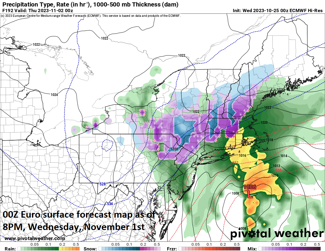
Surface low pressure may form during the middle of next week along a frontal boundary zone at the leading edge of a cold air mass. It is not out of the question that this potential system would have the chance of producing some snow or a mix of snow, ice and rain across interior, higher-elevation sections of the Mid-Atlantic/NE US. Map courtesy Pivotal Weather, ECMWF
Overview
The transition on the calendar from October-to-November will be pretty dramatic across the Mid-Atlantic and Northeast US from a weather point of view. The latter part of this week will feature record challenging warmth in much of the Mid-Atlantic/Northeast US where high temperatures of up to 80 degrees are on the table. The weather will change dramatically next week, however, with the influx of a cold air mass that could feature some snow or a mix of snow, ice and rain in the same part of the country that experiences the surge of warmth later this week. Next week’s cold shot promises to be fairly quick – likely a 2-3 day event – as warmer air is likely to surge back to the north and east into the Mid-Atlantic/Northeast US by the first weekend of November.
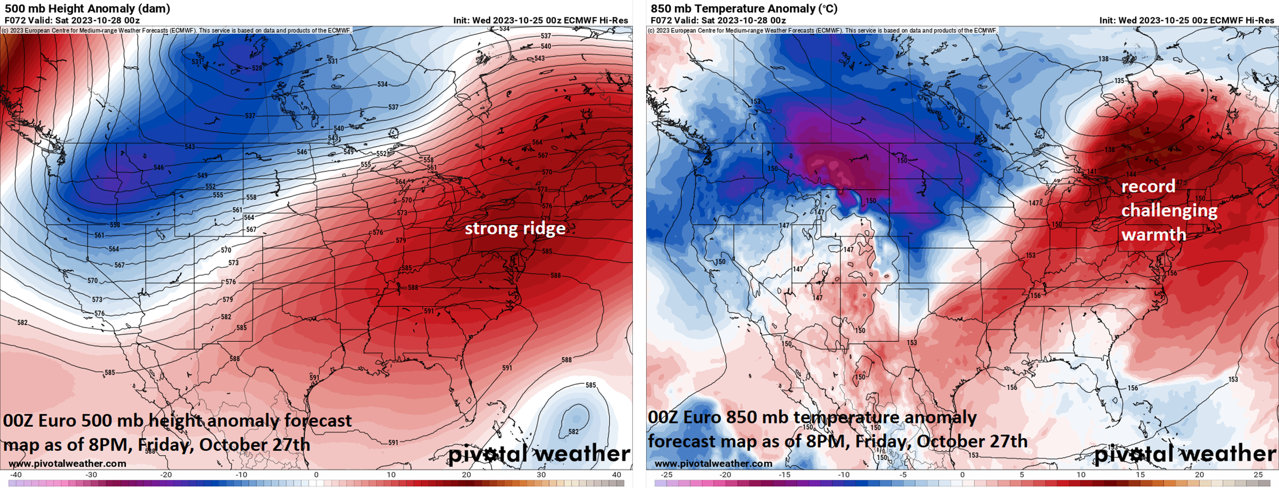
A surge of record challenging warmth will push into the Mid-Atlantic/Northeast US later this week and into the weekend with strong upper-level ridging in control of the weather in the eastern states. Maps courtesy Pivotal Weather, ECMWF (500 mb height anomalies left, 850 mb temperature anomalies right)
Details
A warming trend begins in earnest today across the Mid-Atlantic/Northeast US and it intensifies on Thursday, Friday and Saturday. Temperatures will peak at or slightly above the 70 degree mark this afternoon along much of the DC-to-Philly-to-NYC corridor and can climb to 80 degrees by the end of the week and this will challenge records in many spots. High pressure at all levels of the atmosphere will remain in control across the eastern states allowing for plenty of sunshine and rain-free conditions each day into the weekend.

An influx of cold air will reach the Mid-Atlantic/Northeast US by the middle of next week as we transition from October to November. An upper-level trough may result in the formation of surface low pressure along the eastern seaboard and with the incoming cold air mass, the result may be some snow or a mix of snow, ice and rain in portions of the interior Mid-Atlantic/NE US. Maps courtesy Pivotal Weather, ECMWF (500 mb height anomalies left, 850 mb temperature anomalies right)
The overall weather pattern begins to show signs of changing later in the weekend as an initial cold front approaches the Mid-Atlantic/Northeast US from the north and then it’ll tend to stall out. A second cold front approaches the area on Monday and then a reinforcing cold front comes later Tuesday which happens to be Halloween Day, October 31st. Much colder air should push into the northeastern states by the time Wednesday, November 1st rolls around and a wave of low pressure could form along the frontal boundary zone along the eastern seaboard supported aloft by an upper-level low. If this low pressure indeed forms, it could produce snow or a mixture of snow, ice and rain across some interior, higher-elevation locations of the northeastern states by the middle of next week.
Looking ahead, it looks like the cold shot next week will be a 2 or 3 day event with Wednesday and Thursday likely the most impacted days in the Mid-Atlantic/Northeast US. Temperatures are likely to drop to the 30’s across the entire region by early Wednesday morning – the coldest levels so far this season. By the end of next week, upper-level trough will be replaced by an intensifying ridge of high pressure and temperatures should rebound noticeably as we head towards the first weekend in the month of November.
Meteorologist Paul Dorian
Arcfield
arcfieldweather.com
Follow us on Facebook, Twitter, YouTube