2:00 PM | **Snowstorm from Montana to the Dakotas and NW Minnesota…cold shot reaches Mid-Atlantic/NE US by mid-week…snow is on the table across interior, higher elevation locations**
Paul Dorian

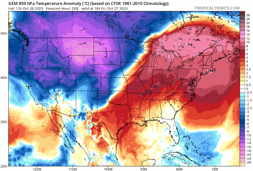
Temperatures crash in the Mid-Atlantic/NE US between the late weekend and the middle of next week as Arctic air pushes to the south and east. This loop of 850 temperature anomalies extends from mid-day Friday to mid-day Wednesday. Maps courtesy tropicaltidbits.com, Canadian Met Centre
Overview
Accumulating snow is falling today from Montana to the Dakotas and NW Minnesota and the cold air mass in that part of the country is going to spread south and east in coming days. In fact, the transition on the calendar in the Mid-Atlantic/Northeast US from the last few days of October to the first few days of November will be quite dramatic. Record challenging warmth in the northeastern quadrant of the nation will extend into the first half of the weekend and there will be a step down in temperatures early next week so that by early Wednesday morning, temperatures will be at their lowest levels so far this season. The influx of the cold air mass may even lead to some snow or a mix of snow, ice and rain across interior higher-elevation locations by the middle of next week.
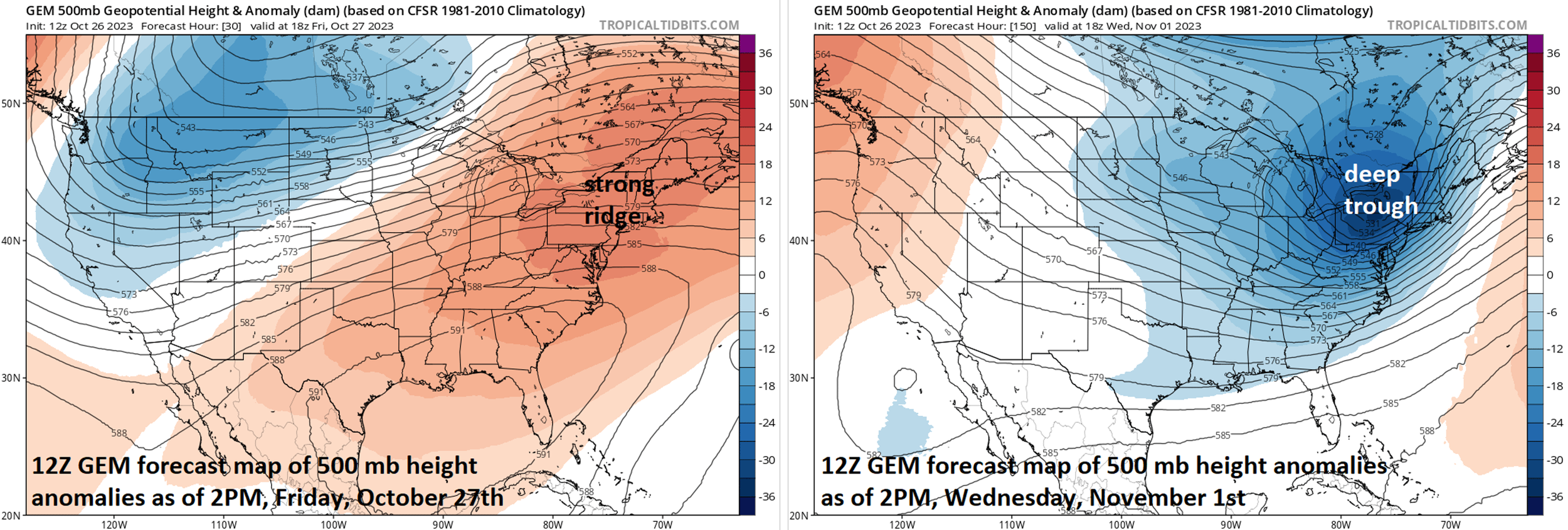
Big-time changes in the atmosphere will take place between now and the middle of next week allowing for today’s record challenging warmth in the Mid-Atlantic/NE US to be replaced by an Arctic air mass. Maps courtesy tropicaltidbits.com, Canadian Met Centre
Details
Arctic air has pushed into the Northern Plains and accumulating snow is accompanying this early winter chill on the order of several inches in much of the region from Montana to the Dakotas and northwester Minnesota. A few examples of the impressive snow totals so far include 11 inches in Glasgow which is their 5th snowiest day on record, 13.4 inches in the capital city of Helena (Montana), and the national parks at Glacier and Yellowstone are buried in a foot of snow.
Meanwhile, the warming trend that began yesterday in the Mid-Atlantic/Northeast US has intensified today and temperatures are soaring through the 70’s across the DC-to-Philly-to-NYC corridor. In fact, this surge of warmth will continue through Saturday in much of the Mid-Atlantic/Northeast US and records will be challenged in many spots. High pressure at all levels of the atmosphere will remain in control across the eastern states allowing for plenty of sunshine and rain-free conditions each day into the weekend.

Low pressure may form along the frontal boundary zone by the middle of next week…if so, accumulating snow may be the result in interior, higher elevation locations of the northeastern US. Map courtesy tropicaltidbits.com, Canadian Met Centre
The overall weather pattern begins to show signs of changing later in the weekend as an initial cold front approaches the Mid-Atlantic/Northeast US from the north and it’ll then tend to stall out and dissipate. A second cold front approaches the area on Monday and then a reinforcing cold front comes later Tuesday which happens to be Halloween Day, October 31st. Much colder air should push into the northeastern states by the time Wednesday morning (November 1st) rolls around with the lowest temperatures of the season so far. In addition, there is a decent chance that a wave of low pressure forms along the frontal boundary zone near the east coast which would be supported aloft by a strong trough. If this low pressure system indeed forms, it could produce snow or a mixture of snow, ice and rain across interior, higher elevation portions of the northeastern states during the middle of next week.
Meteorologist Paul Dorian
Arcfield
arcfieldweather.com
Follow us on Facebook, Twitter, YouTube
Video discussion: