10:30 AM | ****Accelerated accumulating snow threat - now set for late Monday into Tuesday****
Paul Dorian
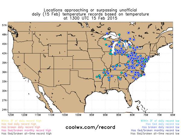 [Record or near record lows from early Sunday; courtesy "coolwx.com"]
Discussion
I should have known better. Tomorrow is President’s Day and this particular holiday has a way of attracting snowstorms (e.g., 1979, 2003). What was once looking like an accumulating snow threat for the time period of Tuesday into Wednesday is now looking like a serious threat for late Monday into Tuesday. In fact, anywhere from a few-to-several inches of snow is looking possible now from late Monday into Tuesday in the I-95 corridor region from DC-to-Philly-to-NYC with perhaps the threat for the heaviest snowfall in the DC metro region. This snow event could certainly have serious implications on the Tuesday morning commute, school openings, etc. Preliminary snowfall estimates by Tuesday mid-day are as follows: 6-10 inches in DC, 4-8 inches in Philly, 3-6 inches in NYC.
Today’s "slap-in-the-face" Arctic cold in the Mid-Atlantic region ensures that this next event will be an all-snow event. Low temperatures in the overnight hours will drop to 0 degrees or even slightly below in many I-95 corridor locations to start the new work week and the scary news is that the same extreme type of cold could happen again later in the week. Records will be challenged in many Mid-Atlantic locations on Monday morning as well as on Thursday and Friday mornings of this upcoming week. Another brutal cold Arctic outbreak - perhaps even colder than the current blast - will follow behind the next storm with the second half of the week featuring widespread, extreme and sustained bitter cold across the eastern US. Incredible stuff.
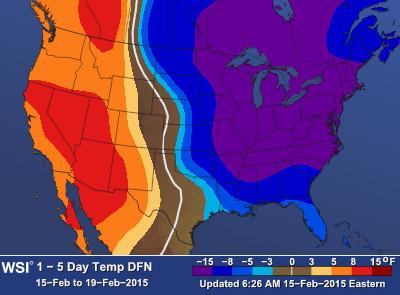 [5-day temperature pattern from today through Thursday...brutal cold in the eastern half of the nation; courtesy WSI]