
12:55 PM Thursday | ****Latest on the upcoming "Blizzard of 2016"****
Paul Dorian
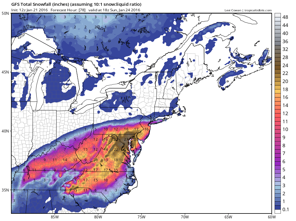
12Z GFS total snowfall map for upcoming storm; courtesy tropicaltidbits.com
Overview of upcoming storm (Thursday 12:55 PM)
This continues to look like a high-impact and long-lasting storm for the Mid-Atlantic region that will include significant snow accumulations, some serious blowing and drifting, coastal flooding and beach erosion given the sustained and strong NE winds (plus full moon), and perhaps even some thunder snow and lightning. The expected arrival of the storm is as follows: DC 2-6pm, Philly 6-10pm, NYC 10pm-2am. Wind gusts could reach 70 mph at coastal locations by later Saturday and 50 mph at inland areas near I-95. There is a chance for a "changeover to" or a "mixing with" rain and/or sleet for awhile during this storm; primarily, to the south and east of the big cities. Also, given the expected long-period of strong winds and the possible mixture in some areas of snow and rain, power outages are a real concern as the weight may be too much for some tree limbs. The snow is likely to come down at varying rates on Saturday and Saturday night as small-scale or "mesoscale" banding is likely to set up given the dynamics involved with this unfolding system. The snow can fall heavily at times on Saturday and Saturday night with blizzard conditions and can also slacken off to “little or nothing” at times as well if a dry slot develops.
National Weather Service (NWS) updates
The Philly NWS has now posted “blizzard watches” for much of the Philly metro region and for virtually all of New Jersey. In the overnight hours, the NYC NWS placed the 5 boroughs of New York City and Long Island under “blizzard watches”. Finally, just in the last hour so, the DC NWS has changed their “blizzard watches” to “blizzard warnings” as they are now about 24 hours away from start time.

12Z NAM total snowfall map, the most "bullish" on snowfall of all the computer forecast models and considered an outlier, but still raises "red flags"; courtesy Weather Bell Analytics
Latest computer forecast info
It continues to look like snowfall accumulations should generally range from 1-2+ feet in the DC-to-Philly-to-NYC corridor with the highest amounts in DC and the lowest around NYC. Specifically, an average of two feet is a reasonable estimate for the DC metro region with as much as 30 inches in spots around the District. Philly could end up in the middle of that range averaging 18" or so. The NYC metro region may be on the low end of that range with total snow amounts closer to one foot. The latest NOAA GFS and NAM computer forecast models (above) and European model (below) have continued to project an area of heavy snow accumulation in the I-95 corridor from DC-to-Philly-to-NYC.
One of the final important questions that we’ll have to answer in the next 24 hours or so is “will there be an extremely sharp snow accumulation gradient on the northern side of the storm” as suggested by some of the models. If so, then there can be a quick drop off of snowfall as one goes to the north in areas like NYC and central PA. The one consistent thing in the computer models all week has been the “bullseye” region for the heaviest snowfall - and that is the DC metro region.

12Z Euro total snowfall map for upcoming storm; courtesy Weather Bell Analytics
DC snowstorm history
One final note for Washington, D.C.: the biggest snowstorm in DC recorded history is known as the "Knickerbocker Blizzard" of January 1922 (1/27-1/28) when 28 inches was recorded. It was called the Knickerbocker Blizzard as it was named after the theater that collapsed due to the heavy snow accumulation. The flat roof of the Knickerbocker Theater - the largest and newest movie house in D.C. at the time - collapsed during a Jan. 28 evening showing of the silent film "Get-Rich-Quick Wallingford," killing 98 people and injuring 133. This long-standing snowstorm record is in jeopardy.
Stay tuned for updates and prepare – it could be one of the all-time greats.
Meteorologist Paul Dorian
Vencore, Inc.