2:00 PM | *Accumulating snow threat continues for the onset of spring*
Paul Dorian

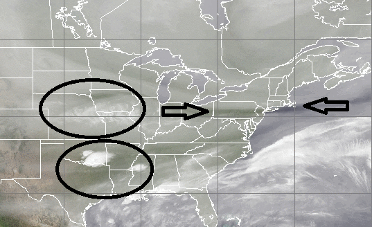
Latest water vapor image highlights Arctic frontal boundary and expanding areas of moisture across the central US; image courtesy CIMSS, University of Wisconsin
Overview
One cold frontal system arrived late yesterday with scattered showers and its passage has sent temperatures down slightly for today, but an even more important and stronger cold front will slide through the region later today. This second frontal passage will usher in noticeably colder (Arctic) air for the weekend as cold high pressure builds to our north. By later tomorrow, moisture will already be streaming into the Mid-Atlantic region as a “front-runner” system heads eastward from the central US. Precipitation is likely to break out across the DC metro region by tomorrow afternoon and then likely reach the Philly metro region sometime tomorrow night. By early Sunday, low pressure will move towards the Mid-Atlantic coastline from the southeastern states. Precipitation intensity and potential snow accumulation amounts on Sunday and Sunday night will depend on the eventual storm track and speed at which this storm strengthens near the Mid-Atlantic coastline. Current snowfall estimates are Dusting-3 inches in the DC metro region, 2-5 inches in the Philly metro region, and 3-6 inches in and around NYC - all still subject to change. The snow should be of the wet variety and should accumulate primarily on non-paved surfaces in the time period from later tomorrow into Sunday night.

12Z GFS total snowfall map for upcoming storm; courtesy tropicaltidbits.com, NOAA
Details
The latest water vapor image of the central and eastern US (top) reveals quite well the location of an approaching Arctic frontal system in the Mid-Atlantic region (appears as black region between the arrows which is where there is dry air). This front slides through the Mid-Atlantic region later today from north-to-south and ushers in colder Arctic air for the weekend. Meanwhile, moisture is already streaming eastward in two areas (both circled) across the central US. The northernmost area of moisture is associated with a “front-runner” system that should produce precipitation across the DC metro region as early as mid-day on Saturday as it is moving quite quickly. The area of moisture in the south-central US will be heading into the southeastern US over the next 12 to 24 hours and this is where low pressure will form later tomorrow. That low pressure system will then push towards the Mid-Atlantic coastline on Sunday and is likely to spread additional precipitation to the I-95 corridor. Some of the latest model guidance suggests this low pressure area will stay far enough off the coast to prevent anything significant in terms of accumulating snow for the DC-to-Philly-to-NYC corridor; however, it is still a close call and there are reasons to doubt this possible outcome.

09Z SREF forecast map for early Sunday afternoon with Mid-Atlantic coastal low position circled for the SREF and NAM models (SREF in black, 12Z NAM in magenta)
Computer forecast models
The overnight (00Z) European model shifted farther east with its storm track; consequently, reduced substantially its snowfall projections for this upcoming system compared to yesterday’s morning run of the model. Today’s (12Z) GFS model forecast continues with its trend for a “weaker and off the coast” solution thereby reducing chances for significant snow accumulations in the I-95 corridor (see latest GFS snowfall map above). The most recent 09Z Short-Range Ensemble Forecast (SREF) model run; however, still maintains a “tucked in” solution for the positioning of the low pressure which is one reason to continue to monitor this situation closely as there are signs that this "close to the coast" scenario could still take place resulting in higher snowfall amounts for the I-95 corridor. The SREF map (above) depicts the location of the low pressure system for early Sunday afternoon (black "L") and juxtaposes (in magenta) the location of the storm from the latest NAM computer model run which is noticeably farther to the east. The 12Z Canadian model has a stronger and slower moving coastal storm compared to the latest GFS; consequently, it generates more snowfall for the DC-to-Philly-to-NYC strip (below).
Stay tuned.

12Z Canadian model forecast map of total snowfall for upcoming storm; map courtesy tropicatidbits.com
Meteorologist Paul Dorian
Vencore, Inc.
Extended morning video discussion: