
6:00 AM (Monday) | ****March snow storm from DC-to-Boston****
Paul Dorian

06Z GFS forecast map for Tuesday morning; courtesy tropicaltidbits.com, NOAA/EMC
Overview
All systems are go for a major storm to roar up the east coast tonight and Tuesday and it should result in a substantial snowfall for the I-95 corridor from DC-to-Boston. The “sweet spot” for heaviest snowfall amounts should end up being just to the north and west of Route I-95 where more than a foot can fall in many suburban locations of the big cities. The precipitation may begin as a mix in the DC metro region, but then should become primarily snow and it should be primarily in the form of snow throughout the event in Philly and NYC. Just to the south and east of Route I-95, mixing with rain or ice will be an issue and there will be a sharp drop off in snowfall totals from that narrow zone to the coastline. In addition to the heavy precipitation, winds will become a problem with this powerful coastal storm and power outages are even a possibility in areas with heavy, wet snow accumulations and strong wind gusts. While the brunt of the storm will be later tonight and tomorrow morning in terms of the heaviest snowfall, there will be enough instability in the upper-levels of the atmosphere that some “wrap around” snow is quite likely later Tuesday and even on Wednesday which can add some to the total accumulation amounts. It stays very cold following the storm on Wednesday and Thursday.
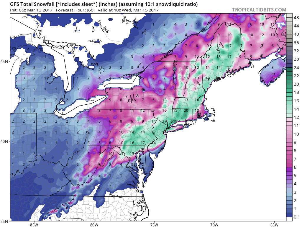
06Z GFS total snowfall map for the upcoming storm; map courtesy tropicaltidbits.com, NOAA/EMC
More Details
It stays cold, but dry through most of today as low pressure drops southeastward through the Ohio Valley. By late tonight, a coastal low will begin taking over as the primary low probably right near the Outer Banks of North Carolina. This low will intensify rapidly as it turns northeast likely reaching a position off the NJ coastline come early tomorrow morning. The upper level features that will help spawn this major coastal storm will eventually coalesce into one deep upper-level trough in the Northeast US and extend snow chances into late Tuesday and even Wednesday.

A little humor courtesy abc news 6 (Philly)
The likely arrival time for the snow in the Mid-Atlantic's I-95 corridor is as follows: DC metro region 5-9pm, Philly metro region 8pm-12am, and NYC metro region 10pm-2am. Updated snowfall estimates are as follows: DC metro region 8-14 inches, Philly metro region 12-20 inches, and NYC metro region 14-22 inches. In all cases, the higher amounts in the accumulation range will be to the northwest of the metro regions; especially, in higher elevation locations, and the lower amounts to the southeast. Winds should persist out of the Northeast during the storm and could gust to 30 mph in DC, 40 mph in Philly, and 50 mph in NYC (higher gusts likely at coastal areas).
Check back to the web site for updates as a slight shift in track can make a big difference. The last great snowstorm during the month of March for the Mid-Atlantic region was the "Storm of the Century" in March 1993.
Meteorologist Paul Dorian
Vencore, Inc.
vencoreweather.com