
2:45 PM | *An early season Arctic blast to arrive in the eastern US by the middle of next week*
Paul Dorian

Widespread colder-than-normal air by the middle of next week in the eastern half of the nation; courtesy ECMWF, tropicaltidbits.com
Overview
The active weather pattern that we have been experiencing in the eastern US during the past several weeks will continue through this week with a strong cold frontal passage later today and then another low pressure system to deal with on Friday. That late week low pressure system will usher in a much colder-than-normal air mass for the weekend, but that “initial” cold shot looks pale in comparison to what might arrive in the eastern US by the middle of next week. An Arctic air mass that originates in Siberia looks like it will push across the North Pole this weekend and then drop southward through Canada early next week. At the same time, low pressure is likely to push out of the Gulf of Mexico and towards the Mid-Atlantic coastline and potentially generate yet another soaking rain event in the Monday night/Tuesday time frame. The passage of this storm system will become the mechanism to allow the Arctic air mass to spread to the east coast in the Tuesday night/Wednesday time frame.

The flow of air at 500 mb by the middle of next week moves air from Siberia to the central US; courtesy ECMWF, tropicaltidbits.com
Details
Warmer air has pushed into the Mid-Atlantic region today ahead of a strong cold frontal system that is heading eastward from the Midwest. This strong cold front is already producing occasional rain in the I-95 corridor and there can be a strong-to-severe thunderstorm mixed in as well later in the day. Following the frontal passage, cooler air will push into the region for the next couple of days and then a new low pressure system will head in this direction on Friday from the southern states. This system will generate more rain here and then it will be followed by a colder-than-normal air mass for the upcoming weekend.
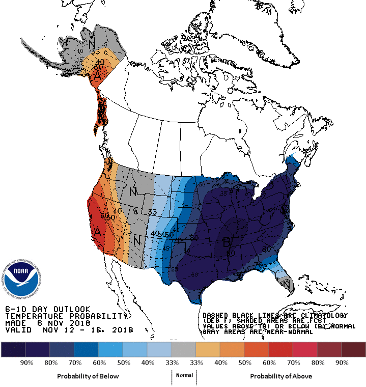
NOAA’s 6-10 day outlook for temperature probabilities with an extremely high chance of colder-than-normal conditions across the eastern half of the nation
Looking ahead to next week, it looks like an even colder and more widespread air mass will push across the North Pole from Siberia and into Canada early next week. At the same time, low pressure with copious amounts of moisture will push out of the Gulf of Mexico and towards the Northeast US. This potential strong storm could very well generate yet another soaking rain event for the Mid-Atlantic region in the Monday night/Tuesday time period.

12Z Euro features a deep upper-level low in the Northeast US during the middle of next week; courtesy ECMWF, tropicaltidbits.com
Once this storm passes by to the northeast, the flood gates will open and Arctic air will pour into the eastern states in the Tuesday night/Wednesday time frame riding in on strong NW winds. This Arctic blast is not likely to be all that long-lasting as there are signs that there will additional warm air outbreaks during the latter half of November and into the month of December before winter weather really locks into place.
Meteorologist Paul Dorian
Perspecta, Inc.
perspectaweather.com