
1:20 PM | *The Great Blizzard of March 18-21, 1958…one of the worst snowstorms ever in Pennsylvania…some similarities with next week’s expected pattern*
Paul Dorian

Truck delivers fuel to York County, PA after the blizzard of March 18-21, 1958
Overview
March is known to feature some crazy and surprising weather and the 1958 blizzard that occurred in the Mid-Atlantic region between March 18th and 23rd was indeed rather unexpected. In general, forecasts on the morning of March 18th had no mention of snow. This was in an era when computer forecast models were just in their infancy and it was even before satellite imagery existed which could aid in the forecast. By afternoon on that particular day, the light rain had changed into huge, wet snowflakes and - for the next few days - history was being made.
Discussion
This was a relatively warm storm and it was quite a struggle for the precipitation to fall in the form of snow. However, as low pressure intensified off of the Mid-Atlantic coastline, heavy, wet snow began to pile up. Under the weight of the heavy wet snow, it didn’t take long for trees to start snapping in the Mid-Atlantic region and power outages spread as electric power lines started coming down. In addition, many houses suffered severe damage to roofs, porches and sheds as incredible amounts of heavy wet snow piled up.
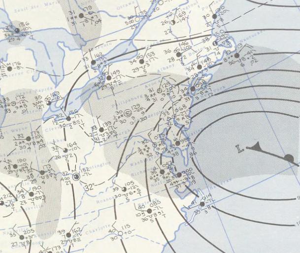
Surface map on March 20th, 1958; courtesy NOAA, Kocin and Uccellini (1990, 2004)
The most striking characteristic of this storm was its slow-movement resulting in substantial accumulations over a several day period. Also, as is often the case in March, the snow accumulations during this event became extremely dependent upon elevation whereby significant differences occurred at differing elevations. A couple degrees of difference on the thermometer between lower and higher elevation locations made huge differences in snowfall totals. One of the most amazing measurements occurred at the Morgantown, PA exchange of the PA Turnpike (elevation of 750 feet) where an astonishing 50 inches of snow accumulated during the entire March blizzard - still the highest ever for a single snowstorm in southeastern PA. Specifically, according to NOAA’s National Climatic Data Center, Morgantown, PA reported 6 inches of snow on the 19th, 38 inches on the 20th (a daily record) and then another 6 inches on the 21st for a total of 50 inches during the long-lasting event.
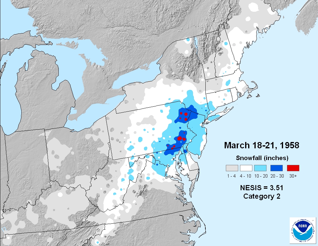
Snowfall totals for the period of March 18-21, 1958; courtesy NOAA; Kocin and Uccellini (1990, 2004)
The storm that hit on March 18-21, 1958 had arguably the biggest impact of any storm ever to hit the Lancaster, PA area. While only 13" of heavy wet snow accumulated in the city of Lancaster, 2 to 3 feet of snow fell across the higher terrain of northern and eastern Lancaster County. In fact, snow piled up on ridge tops all the way from southeastern PA to northeastern PA with an incredible five feet of snow (60 inches) covering the ground by March 23rd in the small Poconos village of Gouldsboro – still the greatest amount ever in the state of Pennsylvania for a single snowstorm. Chester County, PA was also suffering through perhaps its biggest snowstorm ever with 36 inches reported in West Chester and 40 inches in West Grove (Source).
Other notable snowfall measurements in Pennsylvania included 35 inches in Stroudsburg and 20 inches in Allentown. This storm pounded areas just south of the Mason-Dixon Line as well including Mount Airy, MD where 33 inches were reported and in Baltimore (8.4 inches) more than 100,000 people lost power.
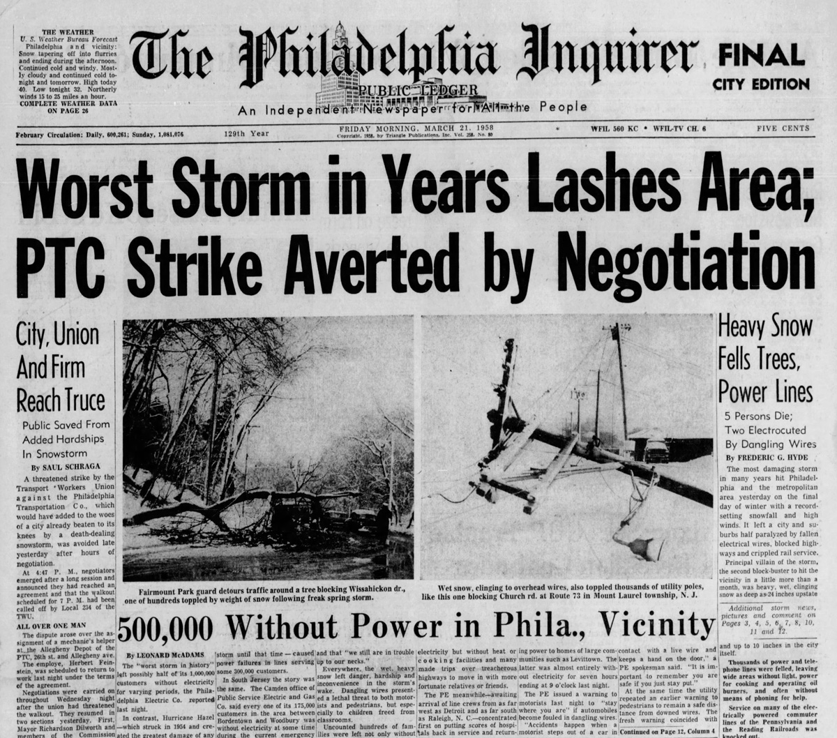
The “Philly Inquirer” headline on March 21, 1958 regarding the blizzard which became known as the “Equinox Storm”
In lower elevation location such as in the city of Philadelphia “only” 11.4 inches fell as slightly milder temperatures and the lack of orographic enhancement (i.e., precipitation being “squeezed out” of the atmosphere due to rising air on windward-facing mountains). Other urban centers were hit as well with this late season snowstorm including Washington, DC at 4.8 inches, Central Park, NY at 11.7 inches and Boston, MA at 6.7 inches. This storm was not the only great snowstorm in the winter of 1957-1958 as just four weeks earlier another blizzard occurred in much of the same region.
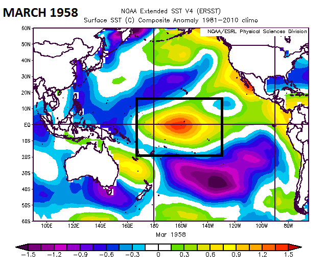
“Centrally-based” El Nino in the equatorial Pacific Ocean during March 1958 and there were two great snowstorms in the Mid-Atlantic region; courtesy NOAA
Some similarities between March 1958 and next week’s possible nor’easter
While the winter of 1957-1958 featured an El Nino (“centrally-based") in the equatorial Pacific Ocean – unlike this season’s La Nina – there are interesting similarities to the overall pattern associated with the March 1958 blizzard and a possible nor’easter next week in the Mid-Atlantic/Northeast US. One of the keys to the recent cold and stormy pattern that we have been experiencing in the Mid-Atlantic/Northeast US is strong and persistent high-latitude blocking (negative NAO) positioned to our north over northern Canada and Greenland and this will likely continue for the foreseeable future. In 1958, strong high-latitude blocking was in place during the blizzard of March 18-21 and there are other similarities between the 500 mb height anomaly pattern back then to the predicted pattern for next week’s potential long-lasting nor’easter.
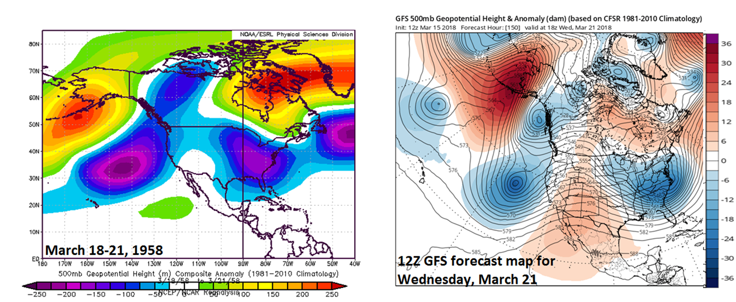
The 500 mb height anomaly pattern during the March 18-21, 1958 blizzard (left) featured strong high-latitude blocking and there are other similarities with the predicted upper-air pattern for next week’s potential nor’easter (right, 12Z Thursday GFS 500 mb height anomalies for Wednesday, March 21); courtesy NOAA, tropicaltidbits.com
Specifically, the Pacific Ocean featured strong ridging centered near Alaska’s Aleutian Islands and a deep upper-level trough west of California and this is predicted by the 12Z GFS for next Wednesday, March 21st. In addition, strong high-latitude blocking was centered from Hudson Bay, Canada to Greenland during the March 1958 blizzard and there were negative height anomalies across the eastern US. This is pretty similar to the predicted pattern for next week although the current GFS is somewhat weaker on the high-latitude blocking. While there are many important details still to be ironed out regarding next week's potential storm system, it does look like a long-lasting event - similar to March 18-21, 1958 - and there is little doubt that elevation will play an important role.
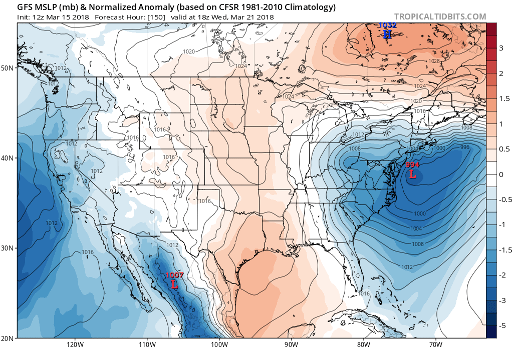
12Z Thursday GFS forecast map of mean sea level pressure anomaly for next Wednesday, March 21st with similar positioning compared to the March 1958 blizzard; courtesy NOAA/EMC, tropicaltidbits.com
Here is the “News of the Day” video from March 1958 regarding the March 1958 blizzard (courtesy YouTube).
Meteorologist Paul Dorian
Vencore, Inc.
vencoreweather.com