2:10 PM | *****Mixed precipitation on Tuesday to be followed by a major snowstorm for the I-95 corridor*****
Paul Dorian

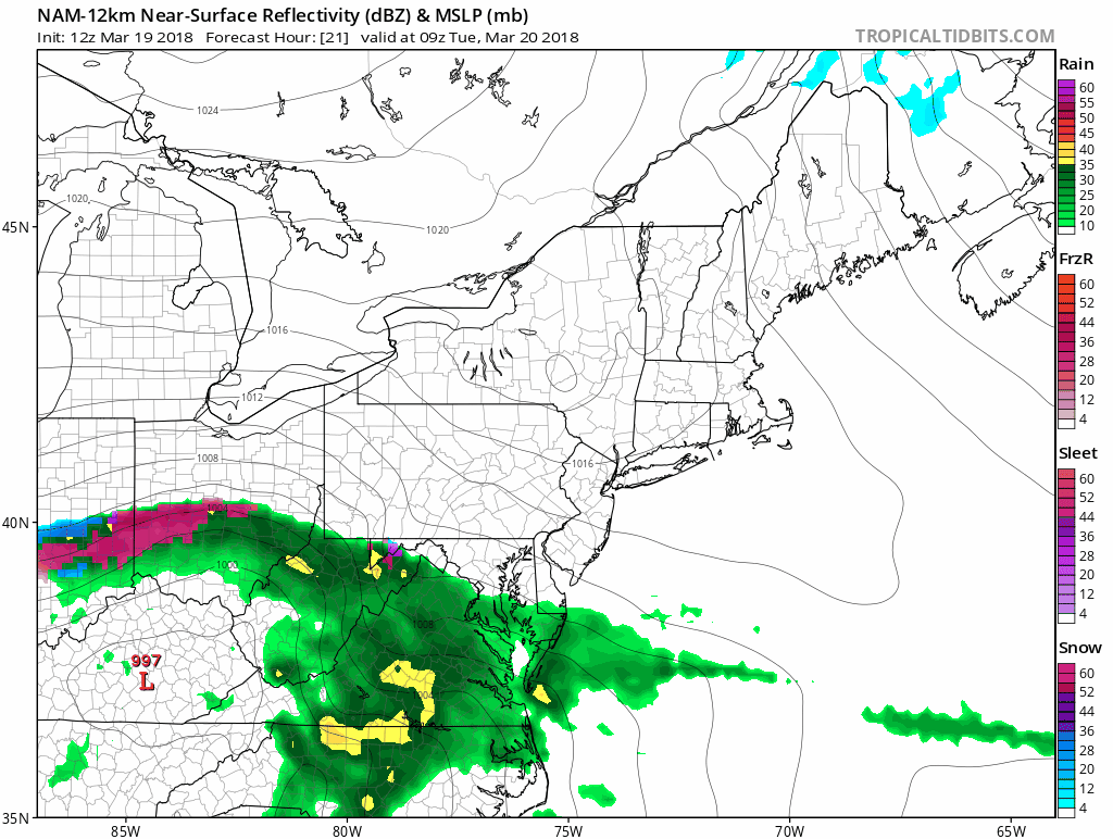
12Z NAM (12-km) loop of surface forecast maps from hour 21 (5AM Tuesday) to hour 66 (2AM Thursday) in 1-hour increments until hour 24 and then 3-hour increments thereafter. [Sleet and/or freezing rain is displayed in purple, pink; snow in blue; rain in green; maps courtesy NOAA/EMC, tropicaltidbits.com]
Overview
Spring officially begins on Tuesday and the weather will be anything but spring-like in the Mid-Atlantic region. Strong, cold high pressure from southeastern Canada will build into the Northeast US over the next 24 hours and this will be a key player and an important cold air source for the Mid-Atlantic region during the upcoming long-lasting and significant weather event. This upcoming event will, in fact, be kind of a "two-parter" with the first system likely to bring a mixed bag of sleet, snow and/or rain on Tuesday and this could include an extended period of icing. The second and very likely stronger system comes Tuesday night and Wednesday and this could develop into an all-out snowstorm for the DC-to-Philly-to-NYC-to-Boston corridor with significant snow on the order of a foot or more possible in much of that region. In addition, there will be increasing NE winds adding to the threat of power outages and perhaps even possible isolated "thunder snow".
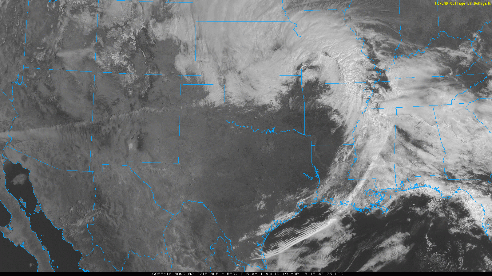
The genesis of the storm...low pressure in the middle of the country today will spawn severe weather in the Deep South; image courtesy NOAA
Discussion
All morning computer forecast models from the NAM, GFS to the Euro have now been reviewed and they tend to agree on a long-lasting and major event for the I-95 corridor from Tuesday into Wednesday. Low pressure will head towards the Ohio Valley early tomorrow and it will bring significant snow to southwestern PA and much of West Virginia on Tuesday and likely a mixed bag of sleet, snow and/or rain to the I-95 corridor and this could include an extended period with sleet and/or freezing rain. Since the precipitation will likely be of the mixed variety, snow accumulations are likely to be limited during the daytime hours on Tuesday, but there can be some icing on untreated surfaces. This initial Ohio Valley low pressure system will then begin to transfer energy to a secondary storm off the Virginia coastline by later tomorrow and this will become the main player in the I-95 corridor tomorrow night and Wednesday.
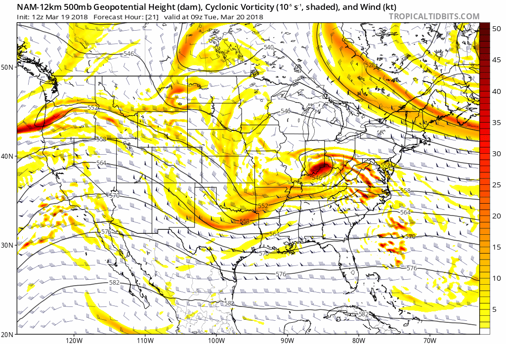
12Z NAM (12-km) loop of forecast 500 mb maps from hour 21 (5AM Tuesday) to hour 66 (2AM Thursday) in 1-hour increments until hour 24 and then 3-hour increments thereafter; maps courtesy NOAA/EMC, tropicaltidbits.com
As colder air continues to feed in from the north on Tuesday (from the cold high pressure system to the north), any mixed precipitation is likely to change to all snow in the DC-to-Philly-to-NYC corridor later tomorrow or tomorrow night and snow will be the main precipitation type from tomorrow night into Wednesday night. In addition, as the secondary storm intensifies near the Mid-Atlantic coastline, the pressure gradient will tighten and NE winds will increase. The combination of increasing NE winds and heavy, wet snow could, unfortunately, potentially lead to some power outages on Wednesday. The second storm should wind down Wednesday night and it’ll stay cold later this week and into the weekend and, believe it or not, there may be yet another nor’easter to worry about late this weekend or early next week and the cold pattern looks to stay in tact right into April.

12Z Euro forecast map for Wednesday evening...an I-95 special. Credit ECMWF (p-type), weathermodels.com (Dr. Ryan Maue)
The loop of upper air (500 mb) forecast maps from the 12Z NAM (12-km version) show several important features that are generally favorable for a snowstorm in the I-95 corridor. First, the confluence in the wind flow over the northern part of New England/SE Canada tends to weaken and push off to the east from later tomorrow into Wednesday and this should allow for a movement to the northeast of the coastal surface low pressure system. Second, the upper-level low that spins into the Ohio Valley later tomorrow, ultimately takes on a "negative-tilt" with its orientation axis extending from northwest-to-southeast. This typically leads to tremendous upward motion on the southeast flank of the upper-level low – which, in this case, should be right off the Mid-Atlantic coastline where low pressure is likely to form and intensify. Finally, the upper-air pattern will develop a ridge of high pressure over the Rockies by mid-week and this is usually a favorable feature for I-95 corridor snowstorms.

Total similar snowfall maps as depicted by the 12-km version of the NAM (left) and 3-km version of the NAM (right) utilizing relatively conservative methods of calculation; maps courtesy NOAA/EMC, tropicaltidbits.com
The two snowfall accumulation maps for the upcoming event that are shown in this posting come from the latest 12-km version of the NAM model and the 3-km version. Both of these snowfall maps are produced utilizing more conservative methods for the calculation of snow accumulation which is probably warranted in this "spring" scenario. Higher snowfall amounts (not shown) are also produced by these models, but they use a 10:1 snow-to-liquid ratio which is probably going to be high for this upcoming event and they include sleet which actually could be an important factor in their totals. All in all, these two snowfall maps provide reasonable ballpark early estimates of potential snow accumulations. My thinking is that a foot or more of snow is indeed possible from this type of system in much of the I-95 corridor from DC-to-Philly-to-NYC-to-Boston and it won't wind down until sometime Wednesday night. Finally, as with many snowstorms in March, elevation is likely to play a critical role in total accumulations with a couple degrees of difference from lower locations potentially making a big difference.
Stay tuned.
Meteorologist Paul Dorian
Vencore, Inc.
vencoreweather.com
Extended morning video discussion: