
10:30 AM | *Early signs for a potential cold and snowy winter in the Mid-Atlantic region*
Paul Dorian

NOAA’s CFSv2 sea surface temperature anomaly forecast map for the upcoming winter season of December/January/February features an El Nino concentrated in the central part of the tropical Pacific Ocean and a large patch of warmer-than-normal water in the Gulf of Alaska. Data source: NOAA/CPC
Overview
The summer solstice has just passed and the days will grow shorter and shorter from here on out until the winter season gets underway. While winter is still a long way off, there are already some clues that can provide some insight as to what kind of weather we can expect around here in the Mid-Atlantic region. First, signs point to the formation of warmer-than-normal sea surface temperatures by the upcoming winter season in two key areas of the Pacific Ocean: 1) the central equatorial region and 2) the Gulf of Alaska. Second, there is little doubt that solar activity will remain on the low side through the upcoming winter season as we are rapidly approaching the next solar minimum phase from an already historically weak solar cycle #24. Finally, one important wintertime cold air source region for the Mid-Atlantic is Greenland and it is currently experiencing above-normal snow and ice cover. While this is in the speculation phase, all of these factors point to the possibility of cold and snowy conditions in the Mid-Atlantic region during the upcoming 2018-2019 winter season.
Centrally-based El Nino in the equatorial Pacific Ocean and warming in the Gulf of Alaska
The Pacific Ocean is by far the planet’s biggest ocean and it has a tremendous influence on all weather and climate around the world. Sea surface temperature anomalies in the equatorial part of the Pacific Ocean can be quite useful in the formulation of a winter season outlook for the Mid-Atlantic region, but the magnitude and exact positioning of the anomalies must be factored in. For instance, a strong El Nino (i.e., warmer-than-normal water) based in the eastern tropical Pacific Ocean can flood the Mid-Atlantic region and the eastern third of the nation with persistent warmer-than-normal air during a given winter season (e.g., 1972-1973, 1997-1998). On the other hand, a weak-to-moderate El Nino based in the central part of the tropical Pacific has been associated with cold and snowy winter conditions in the Mid-Atlantic region (e.g., 2002-2003, 2009-2010).
There are two reasons why a weak-to-moderate and centrally-based El Nino can increase the chances for snowy winter weather in this part of the country. First, it tends to provide added moisture and “lift” to the southern branch of the jet stream which, in turn, raises the chances for east coast storms - the type of storm track that tends to favor snow in the big cities of the I-95 corridor. Second, a weak-to-moderate and centrally-based El Nino is less likely to flood the eastern US with warmer-than-normal air; in fact, it tends to allow for cold air masses to drop southward into the northeastern US from Canada, Greenland and/or Siberia.
In addition to the equatorial part of the Pacific Ocean, sea surface temperatures in the northern part can play an important role in a Mid-Atlantic winter season. For example, if there is a persistent area of warmer-than-normal water tucked in near the southern Alaskan coastline, it can result in consistent high pressure ridging along the US and Canadian west coasts, a condition known to meteorologists as the negative Eastern Pacific Oscillation (-EPO). This, in turn, often results in a dip of the upper-level jet stream in the eastern US which allows for the penetration of cold air masses from the northern latitudes into the Mid-Atlantic region during the winter season. This kind of pattern with a persistent Canada/US west coast ridge of high pressure has actually taken place on multiple occasions in the middle part of this decade (e.g., 2014-2015, 2013-2014).
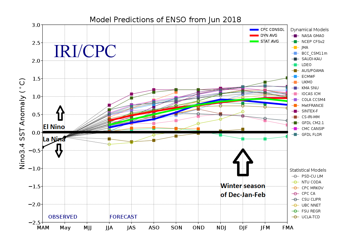
This graph show forecasts made by dynamical and statistical models for sea surface temperature anomalies in the “Nino 3.4” region of the Pacific Ocean for nine overlapping 3-month periods. The vast majority of the models feature weak-to-moderate El Nino conditions by the upcoming winter season of December/January/February (indicated by arrow).
Data source: International Research Institute for Climate and Society/Columbia University
Numerical model forecasts of sea surface temperature anomalies
Many computer forecast models suggest a weak-to-moderate and centrally-based El Nino is likely by later this year and it could last right through the upcoming winter season. Furthermore, numerous models suggest warming will return to the northern part of the Pacific Ocean by the upcoming winter season near the southern Alaskan coastline. Both of these oceanic anomalies would increase the chances for a cold and snowy winter in the Mid-Atlantic region.

The Japan Agency for Marine-Earth Science and Technology (JAMSTEC) sea surface temperature anomaly forecast map for the upcoming winter season of December/January/February features an El Nino focused in the central part of the tropical Pacific Ocean and a large patch of warmer-than-normal water in the Gulf of Alaska (base period for estimation of anomalies is 1983-2006). Click here for data source
The Japan Agency for Marine-Earth Science and Technology (JAMSTEC) computer forecast model predicts a centrally-based El Nino for the upcoming winter season (December-to-February). In addition, the JAMSTEC forecast map of sea surface temperature anomalies features a warmer-than-normal large patch of water tucked in near the southern Alaska coastline and this tends to favor the development of high pressure ridging along the west coasts of Canada and the US which, in turn, can lead to frequent cold air outbreaks into the northeastern US. There is support for this sea surface temperature anomaly forecast by NOAA’s CFSv2 (climate) model which also predicts an El Nino for next winter concentrated in the central part of the tropical Pacific Ocean as well as a large patch of warmer-than-normal water in the Gulf of Alaska.
Low solar activity and high-latitude blocking
In addition to the analysis of sea surface temperature anomalies in the Pacific Ocean, it is valuable in the long-range forecasting of winter weather in the Mid-Atlantic region to evaluate the prospects for high latitude blocking events in the atmosphere. High-latitude blocking during the winter season is characterized by persistent high pressure in northern latitude areas such as Greenland, northern Canada, and Iceland. Without this type of upper-level pattern, it is quite difficult to get sustained cold air outbreaks in the Mid-Atlantic region during the winter season and that is usually a critical requirement for snowstorms in the big cities of the I-95 corridor.
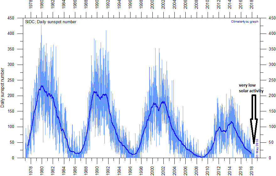
This plot shows the daily observations of the number of sunspots during the last four solar cycles back to 1 January 1977 according to Solar Influences Data Analysis Center (SIDC). The thin blue line indicates the daily sunspot number, while the dark blue line indicates the running annual average. The current low sunspot activity is indicated by the arrow at the lower right of the plot. Last day shown: 31 May 2018. Click here for data source.
Research and empirical observations have shown that low solar activity tends to be correlated with frequent high-latitude atmospheric blocking wintertime patterns in the atmosphere and we are now experiencing one of the weakest solar cycles (#24) in more than a century. Furthermore, this already weak solar cycle is heading rapidly towards the next solar minimum - usually the least active time in a given cycle. In fact, the last solar minimum phase from 2007-to-2009 registered the quietest solar activity period in at least a century and when the inactive sun coincided with a moderate El Nino event in the winter of 2009-2010, the Mid-Atlantic region experienced a cold and snowy winter. In fact, some spots ended up with their snowiest winter on record during the 2009-2010 winter season such as in Washington, DC.
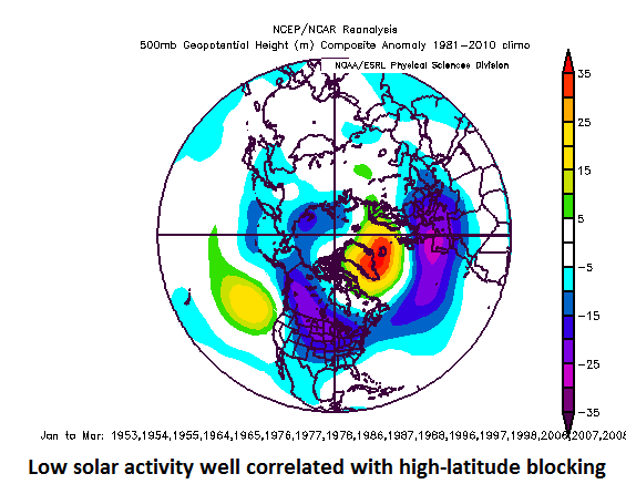
Low solar activity years are well correlated with abnormally high heights at 500 millibars (shown above in orange, yellow) over high-latitude regions like Greenland and Iceland (i.e., high-latitude blocking patterns); data courtesy NOAA/NCAR
The “analog years” plot (above) shows 500 millibar height anomalies in previous low solar activity years (i.e., during solar minimum phases). Higher-than-normal heights tended to dominate near Greenland and Iceland which typically leads to high-latitude blocking patterns and sustained cold air outbreaks into the northeastern US. Based on these empirical observations from previous low solar activity years, odds do favor high-latitude blocking scenarios this upcoming winter season given the strong likelihood for low solar activity to continue right through the winter months.
Greenland as a source region for cold air
An important cold air source region for the Mid-Atlantic region during a given winter season is Greenland and this area becomes especially critical when there are frequent high-latitude blocking patterns in the atmosphere. The snow and ice extent on Greenland is always a useful feature to monitor – even several months before the actual winter season. In fact, Greenland has generally had above-normal snow and ice extent in recent months and continues to do so now as we begin the summer season of 2018. Above-normal snow and ice extent in Greenland is a favorable factor for the formation of colder-than-normal air masses during the fall and winter seasons when the nights grow longer and longer.
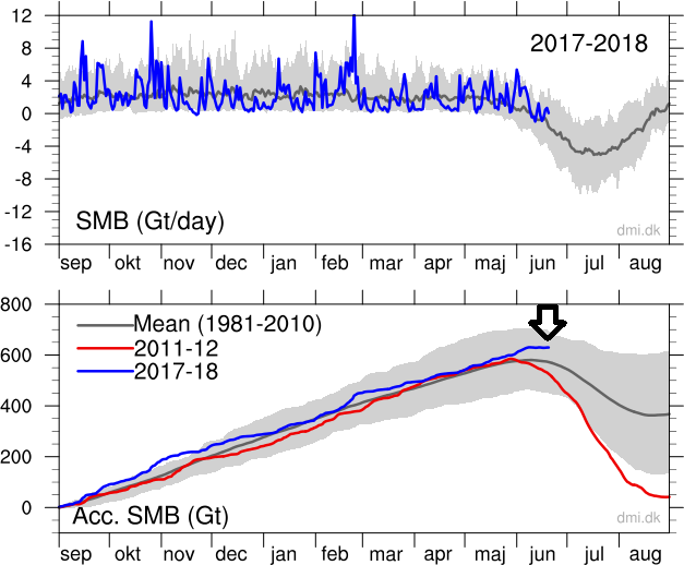
Top: The total daily contribution to the surface mass balance from the entire ice sheet (blue line, Gt/day). Bottom: The accumulated surface mass balance from September 1st to now (blue line, Gt) and the season 2011-12 (red) which had very high summer melt in Greenland. For comparison, the mean curve from the period 1981-2010 is shown (dark gray). The same calendar day in each of the 30 years (in the period 1981-2010) will have its own value. These differences from year-to-year are illustrated by the light gray band. For each calendar day, however, the lowest and highest values of the 30 years have been left out. The arrow (upper right) indicates the current level of snow and ice extent in Greenland with amounts higher than the mean period of 1981-2010. Click here for data source.
Final thoughts
While this is still in the speculation phase, there are early signs for cold and snowy weather conditions in the Mid-Atlantic region during the upcoming 2018-2019 winter season. Specifically, these signs include the current observation of above-normal snow and ice extent in Greenland, low solar activity, and the outlook for warmer-than-normal sea surface temperatures in two key areas of the Pacific Ocean. We’ll continue to closely monitor these important factors here at perspectaweather.com to see how they evolve over the next several months. One word of caution on the sea surface temperature anomaly forecasts, many of these same numerical computer models incorrectly predicted early last year that an El Nino would form by the summer of 2017. That actually never materialized and the neutral conditions in the equatorial Pacific Ocean actually resulted in a much more active tropical season in the Atlantic Basin than expected.
In addition to these early signs, we’ll monitor the overall pressure, wind and temperature patterns over the North Atlantic Ocean as we approach the fall and winter seasons to better determine what to expect next winter in terms of the North Atlantic Oscillation (NAO) and Arctic Oscillation (AO). Also, the snow pack that builds up in Siberia during the autumn season is an important factor that I like to closely monitor every year as it has an influence on that important cold air source region (similar to Greenland) for the Mid-Atlantic region.
Stay tuned…it could be an exciting 2018-2019 winter in the Mid-Atlantic region.
Meteorologist Paul Dorian
Perspecta, Inc.
perspectaweather.com
An extended video discussion on an early preview of the 2018-2019 winter season in the Mid-Atlantic region: