
5:05 AM (Monday) | **Potential tremendous rainfall amounts from Hurricane Florence as an "atmospheric brick wall" sets up**
Paul Dorian
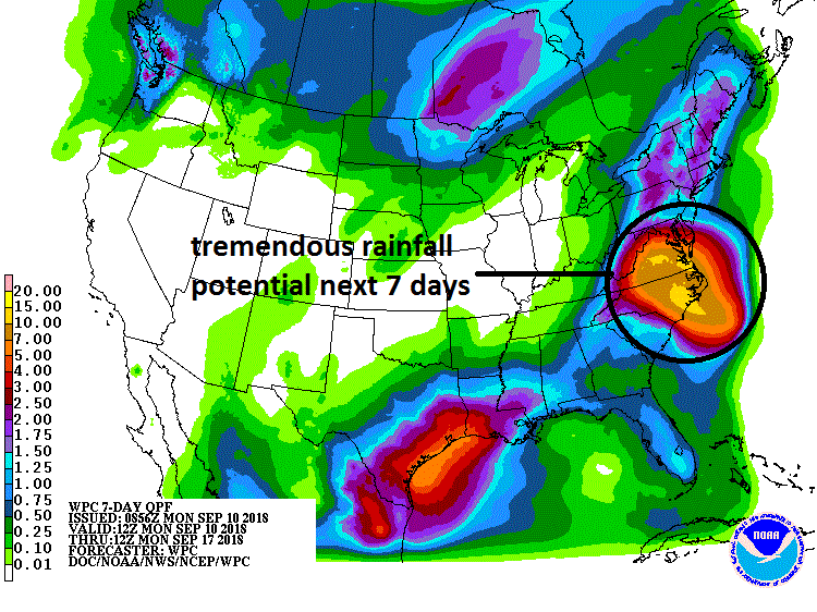
There is potential for tremendous rainfall amounts over the next seven days from Hurricane Florence in the Carolinas and much of the Mid-Atlantic region; courtesy NOAA/WPC
Overview
All eyes are focused on Hurricane Florence as we begin the new week and chances for a major impact on the US east coast continue to grow. Florence is now churning slowly towards the US east coast as a category 2 hurricane and may make a landfall late Thursday or early Friday somewhere along the Carolina coastline – likely with “major” hurricane status. Very strong high pressure ridging is now building at upper levels of the atmosphere across southeastern Canada and the northwestern Atlantic and this will be a key player in the push of Florence towards the east coast over the next few days. In addition, this very strong high pressure ridge will eventually act as an “atmospheric brick wall” for Florence once it reaches the Carolinas and the brakes will be put on any attempt at a northward advance by the storm. This eventual slow down in the northward advance of Florence will allow for an extended period of heavy rainfall and the result could be tremendous rainfall amounts in the Carolinas and perhaps into at least parts of the Mid-Atlantic region.
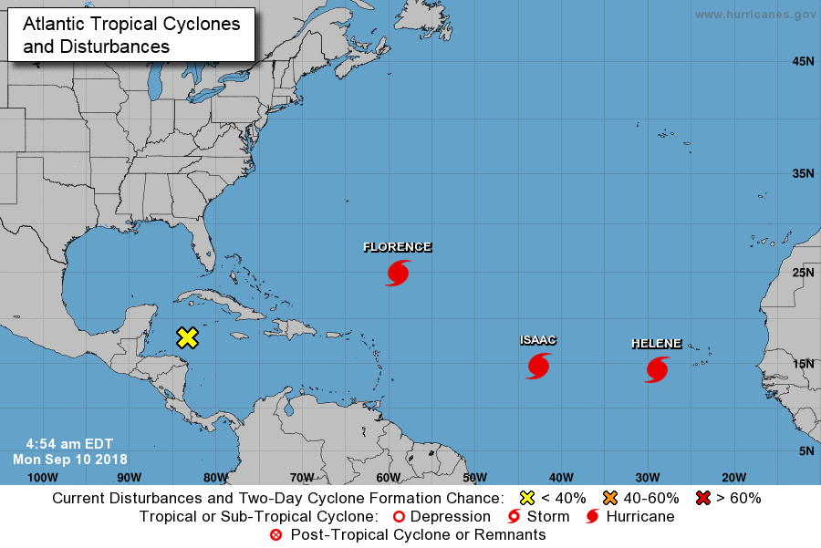
Latest positions of Florence, Isaac and Helene in the very active Atlantic Basin; courtesy NOAA/NHC
Florence
Florence regained hurricane strength on Sunday and is very likely to reach “major” hurricane status within 12-24 hours. The latest readings on Hurricane Florence are as follows: max sustained winds at 105 mph, central pressure at 969 mb and its movement is to the west-northwest at 9 mph. An upper-level trough of low pressure pushed across the north Atlantic this weekend and “left behind” Hurricane Florence which is now under the increasing influence of a strong upper-level ridge expanding to the north across southeastern Canada and the northwestern Atlantic. This ridge will help allow for the movement of Florence to continue to the west over the next couple of days and towards the Carolina coast line.
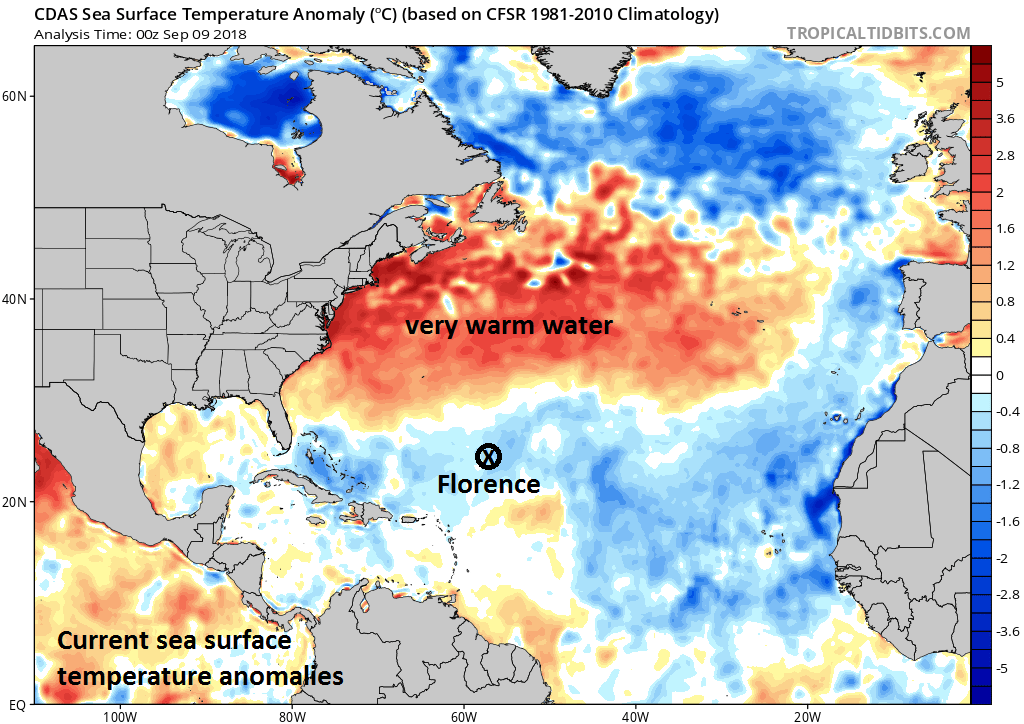
As Hurricane Florence closes in on the US east coast, it will move over very warm water for this time of year (above-normal water temperatures shown in orange) and this will aid in its rapid intensification over the next few days; courtesy NOAA, tropicaltidbits.com
Along this expected near-term path, Hurricane Florence will begin to cross over warmer-than-normal waters in the western Atlantic Ocean which will help in its intensification back to "major" status (i.e., category 3, 4 or 5) and this large warmer-than-normal pocket of water will also aid in the "pumping" up of the very strong ridge of high pressure to the north.
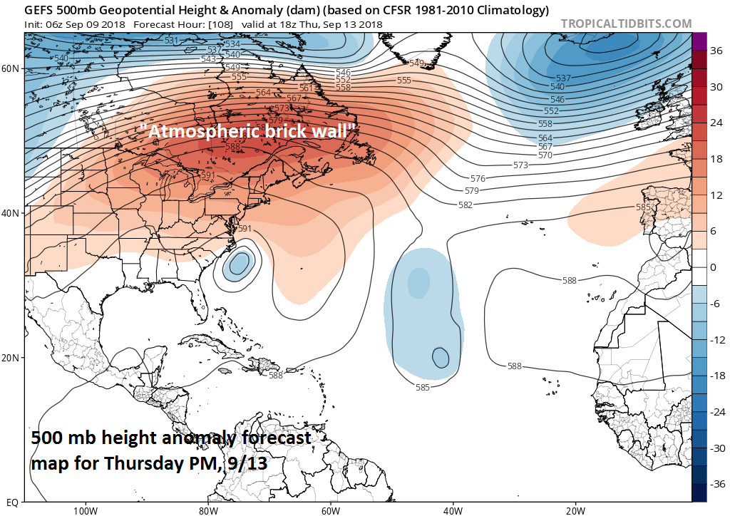
Very strong high pressure ridging will act as an "atmospheric brick wall" and slow down the northward progress of Hurricane Florence; courtesy NOAA, tropicaltidbits.com
On the current path, Florence will likely make landfall late Thursday or early Friday somewhere along the Carolina coastline - perhaps as a category 4 "major" hurricane - and then it’ll try to turn to the north. However, the extremely strong upper-level ridge of high pressure to the north will act as an “atmospheric brick wall” and force Florence to slow down to a crawl in its attempt to move northward. This slow down will allow for an extended period of heavy rainfall in the region from the Carolinas into at least parts of the Mid-Atlantic (e.g., Virginia) and perhaps as far north as the Delmarva Peninsula, Pennsylvania and New Jersey in the period from the end of the week to the early part of next week. The grounds in the much of the eastern US including the Mid-Atlantic region are already well-saturated from the weekend significant rainfall associated with the combination of the remains of Gordon and a frontal system and from numerous heavy rain events during the summer season. Given the already well saturated grounds, any additional heavy rainfall from Florence could potentially lead to widespread and serious flooding problems.
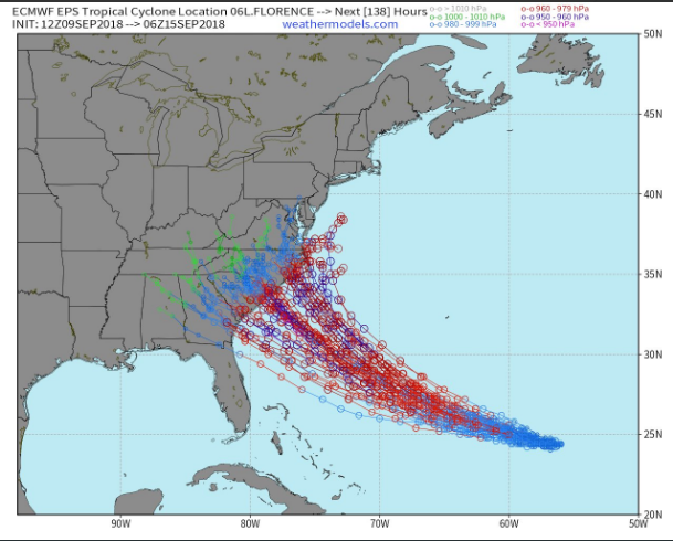
Storm tracks of the individual ensemble members of the (Sunday) 12Z Euro; courtesy weathermodels.com, ECMWF
Isaac, Helene
Two other hurricanes are in the Atlantic Basin and will need to be monitored in coming days. The closest system is Hurricane Isaac (category 1) and it will take a “southern” track and head to the Caribbean Sea – perhaps reaching there by Thursday. Meanwhile, Hurricane Helene (category 1) is expected to curve to the north in coming days and out into the open Atlantic – likely never coming close to the US. According to Philip Klotzbach (Colorado State University), this is the 11th year on record that the Atlantic Ocean has had 3+ hurricanes simultaneously. Other years were 1893, 1926, 1950, 1961, 1967, 1980, 1995, 1998, 2010, and 2017.
Meteorologist Paul Dorian
Perspecta, Inc.
perspectaweather.com