
11:40 AM | ***Precipitation picks up in intensity later today…Arctic front on Wednesday to feature strong wind gusts, snow showers and possible snow squalls…near 0 degrees by early Thursday morning***
Paul Dorian

Overview
A strong cold front is sliding towards the east coast at this hour and upper-level energy in the southern US is enhancing precipitation on its southern end. This enhanced precipitation will move northeast and into the DC-to-Philly-to-NYC corridor later today and continue into the evening hours – mainly in the form of snow by the end of the day. The Arctic front arrives on Wednesday and it will accompanied by strong wind gusts, scattered snow showers and perhaps a heavy snow squall or two. Temperatures will then plunge tomorrow night following the passage of the Arctic front and near zero is a strong likelihood in many suburban locations by early Thursday morning.
Tuesday/Tuesday night
Precipitation has been rather spotty and light this morning and mid-day, but it will increase in intensity later this afternoon as an “initial” cold front arrives in the I-95 corridor. Any mixed precipitation this afternoon should change to all snow by late in the day in the DC-to-Philly corridor and then later this eveining in the NYC metro region. Snow should continue for awhile this evening and end before midnight in most I-95 corridor locations as the cold front slides off the east coast. Untreated road surfaces can get slick in a hurry later today and early tonight as temperatures drop and the snow falls.
Accumulations by later tonight are likely to be in the following ranges by metro region:
DC: a coating to an inch or two in the District; 1-3 inches in the northern and western suburbs
Philly: a coating to an inch or two in Philly; 1-3 inches in the nearby northern and western suburbs; 2-4 inches in the far northern and western suburbs (e.g., western Chester, Upper Bucks, Northern Montgomery Counties)
NYC: a coating to an inch or two
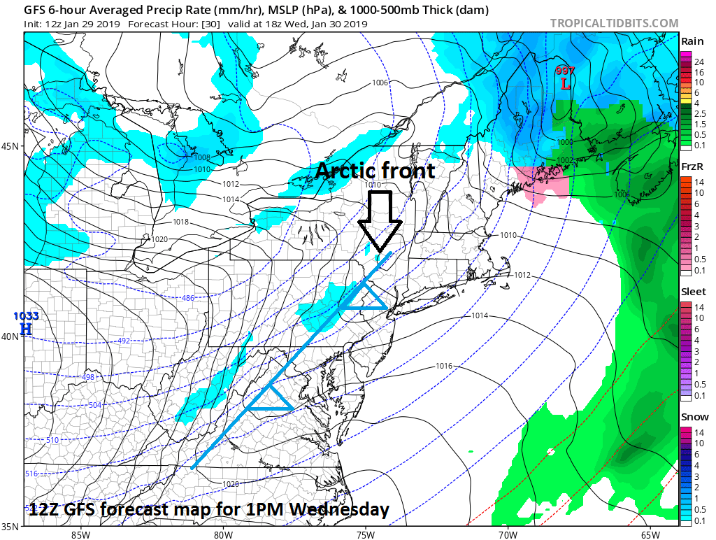
Wednesday
The true Arctic frontal boundary will slide through on Wednesday and it could be an active frontal passage. Winds are likely to gust to 40 mph or so as the front arrives and there can be snow showers in the I-95 corridor. In addition, a few heavier snow squalls could accompany the frontal passage which could produce a quick half inch-to-an inch of accumulation in any given location. The best chance for snow on Wednesday in the DC-to-Philly-to-NYC corridor will be between the hours of 10AM and 4PM.

Wednesday night/Thursday
The full brunt of the Arctic blast for the I-95 corridor will arrive on Wednesday night. Temperatures will plunge tomorrow night and winds will remain strong out of the northwest. By early Thursday, temperatures should be near zero in many suburban locations and wind chills will be well below zero. Afternoon temperatures on Thursday will struggle to climb through the teens and then they should drop to single digits once again later Thursday night.
Friday
It remains well below normal on Friday and another low pressure system will head our way from the Midwest. This next system could produce another small accumulation of snow in the Mid-Atlantic region as we close out the work week. It stays cold on Saturday, but then much milder air is likely to return here early next week.
Meteorologist Paul Dorian
Perspecta, Inc.
perspectaweather.com
Video discussion: