11:20 AM | ***”Round 2” of extended winter weather event to bring accumulating snow, ice to Philly and NYC…icing still a threat in DC suburbs for the overnight***
Paul Dorian

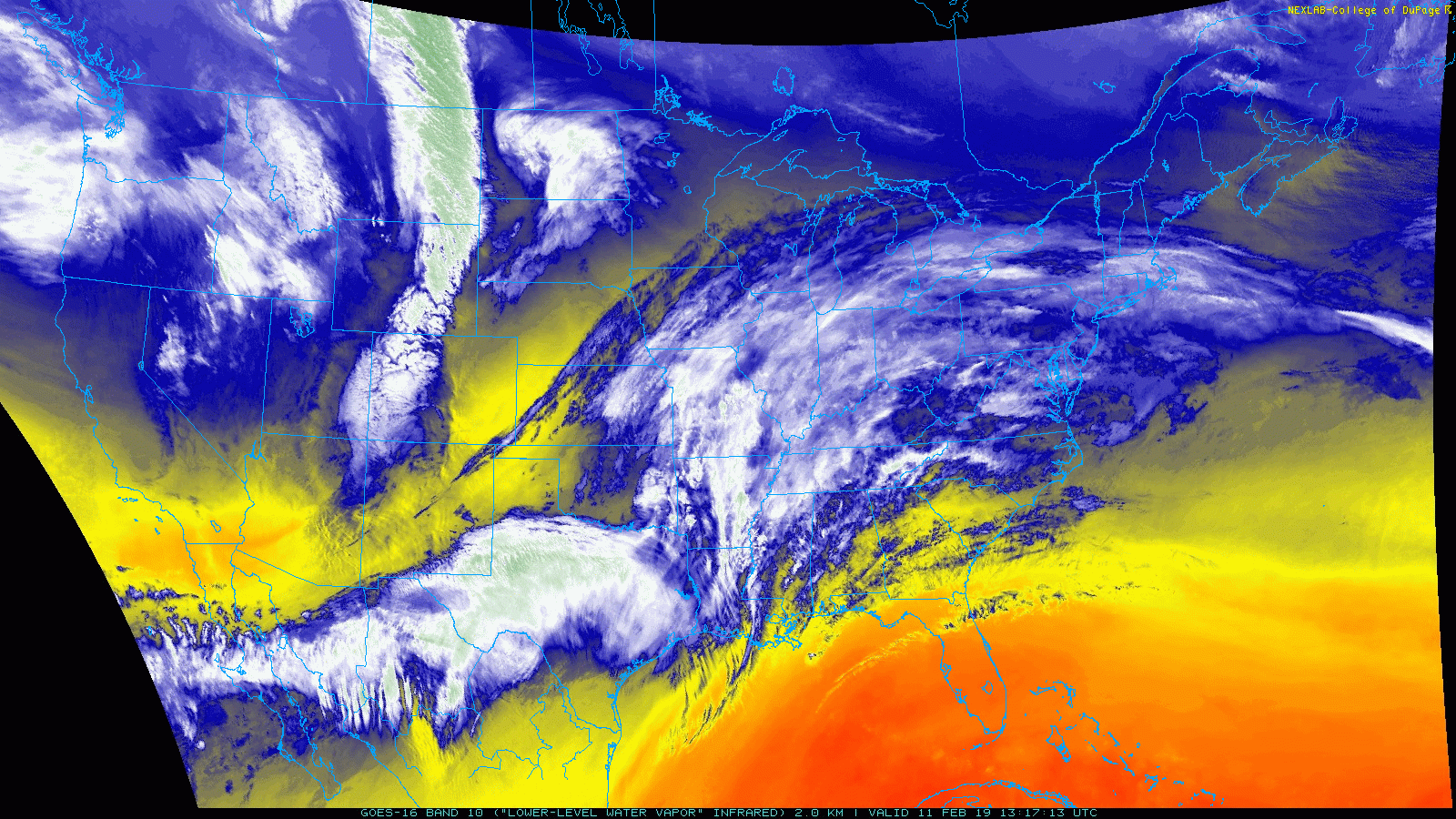
The latest satellite imagery loop of low-level water vapor from GOES-16 shows a large swath of moisture headed towards the Mid-Atlantic region; courtesy College of DuPage, NOAA
Overview
“Round 1” of our extended winter weather event is winding down and “round 2” is about to get underway. The first part of this long event brought some accumulating snow to the Philly metro region and a combination of snow and ice to the DC area while NYC stayed precipitation-free. “Round 2” will result in heavier overall precipitation amounts with accumulating snow and ice in Philly and NYC and an icing threat for some of the suburbs to the north and west of DC.

12Z NAM forecast maps for 1AM Tuesday (left) and 10AM Tuesday (right)…when you see lots of colors this time of year, you can be sure ice is involved. Maps courtesy NOAA, tropicaltidbits.com
General discussion
Latest water vapor imagery indicates there is a lot of moisture headed right towards the Mid-Atlantic region as “round 2” of our extended winter weather event is about to get underway. At the same time, strong high pressure is building into southeastern Canada and this key player will funnel cold air down the east side of the Appalachians later today and tonight. As a result, even though temperatures this afternoon will above freezing in many spots along the I-95 corridor, they’ll likely fall back to freezing or slightly below in the overnight hours and the cold air will be very reluctant to give up its ground on Tuesday.

The large, strong, cold high pressure system over southeastern Canada in this forecast map for 1AM Tuesday is a key player. Courtesy NOAA, tropicaltidbits.com
Philly
In southeastern PA, a lull in the activity is likely during today’s mid-day and afternoon hours. Precipitation will then pick up in intensity late today/early tonight primarily in the form of snow and there can be moderate-to-heavy snow for awhile this evening. The snow is then likely to mix with and/or change to sleet and freezing rain around or shortly after daybreak. New snow accumulations on the order of 2-5 inches are possible before the changeover to a wintry mix and the Tuesday AM commute is likely to be problematic. The cold low-level air will be reluctant to give up its ground on Tuesday so the wintry mix may continue for awhile with an ice buildup possible on untreated surfaces, but plain rain and above freezing temperatures are possible by the end of the day. Later tomorrow night, rain or a wintry mix could change briefly to snow before the precipitation winds down completely.
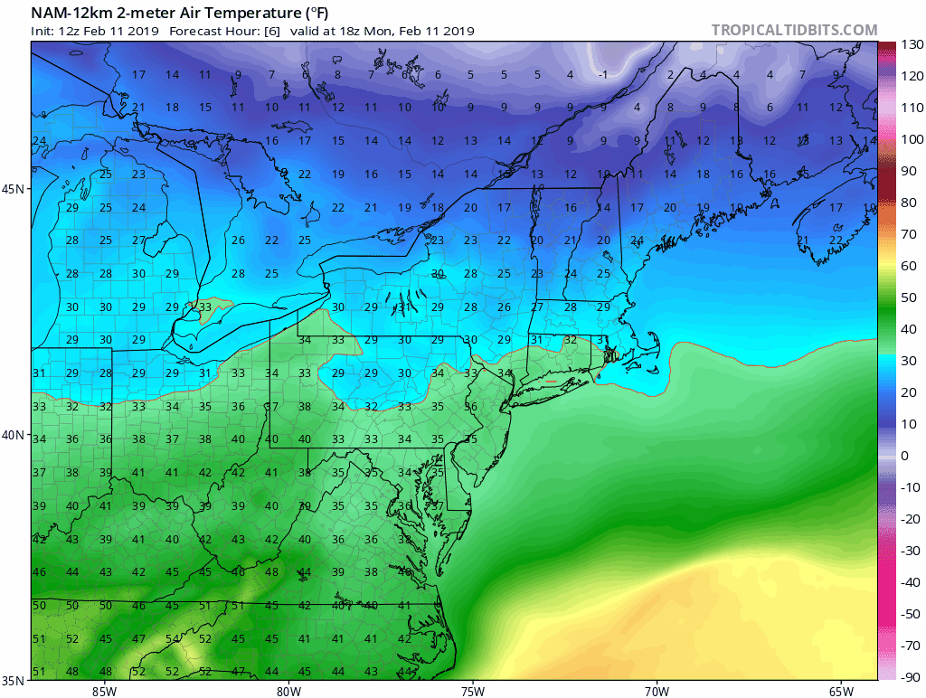
Temperatures will rise to above freezing levels today in many spots along the I-95 corridor, but given the influx of cold air from the north, they’ll drop back to freezing later tonight (loop of surface temperatures from 1PM Monday to 7AM Tuesday using the 12Z NAM model run); maps courtesy NOAA, tropicaltidbits.com
DC
There is likely not going to be a complete stoppage of the precipitation today across the DC metro region as light rain should continue through the afternoon. While the threat for accumulating snow is most likely over with in the DC metro region except for the far northern suburbs (e.g., Frederick, MD), there does remain a threat for some icing. Later tonight, as colder air seeps down the coastline, temperatures will drop back to the freezing mark and the chance for freezing rain and sleet will increase; especially, across the northern and western suburbs. In fact, some of the normally colder northern and western suburbs can see an ice buildup in the overnight hours and the Tuesday AM commute could be slippery in many spots. Later tomorrow, enough milder air should push in for a changeover to plain rain with temperatures climbing to above freezing levels as winds pick up noticeably. Later tomorrow night and early Wednesday, there is a chance that any precipitation that still remains could change back to sleet and/or snow before it winds down completely.
NYC
“Round 1” missed the NYC metro region, but “round 2” will bring accumulating snow and ice and then rain. The precipitation is not likely to reach the NYC metro region until late this evening when snow should break out. The snow should then continue into the early part of Tuesday with accumulations possible on the order of 2-5 inches before a mid-morning changeover to sleet and then to freezing rain. The cold low-level air will be reluctant to give up its ground on Tuesday so the wintry mix may continue for awhile with an ice buildup possible on untreated surfaces, but plain rain and above freezing temperatures are possible by the end of the day. Later tomorrow night, rain or a wintry mix could change back to snow for a brief time before the precipitation winds down completely.

12Z Euro total snowfall forecast map between now and tomorrow night; courtesy ECMWF
Looking ahead
Another storm system will take a somewhat similar track to this current one late this week, but it doesn’t look like there will be a strong high pressure system to the north. Consequently, the late week storm system looks like it will be wet and not white along with relatively mild temperatures. There are signs, however, for multiple wintry weather threats beginning this weekend and continuing well into next week…stay tuned.
Meteorologist Paul Dorian
Perspecta, Inc.
perspectaweather.com
Video discussion: