12:15 PM | *Some snow possible on Saturday in the region from DC-to-Atlantic City, NJ…light precipitation threat in the Mid-Atlantic on Sunday night…third threat comes Tues night/Wed…California storm*
Paul Dorian

A plume of moisture is flowing into California today and contributing to massive amounts of rain (coastal sections) and snow (inland higher elevations); courtesy CIMMS Wisconsin, NOAA
Overview
Three different low pressure systems will threaten at least parts of the Mid-Atlantic region over coming days and this active weather pattern is currently featuring a powerful storm in California. The precipitation shield from the first wave of interest for the Mid-Atlantic region looks like it will have its northern extent stretching from around the DC metro region to Atlantic City, NJ. The second system is likely to be rather weak and could result in light rain and/or snow from Sunday night into early Monday. The third threat to monitor in coming days looks like it will have more moisture available to it and may result in another snow-to-ice-to-rain scenario in the Mid-Atlantic come late Tuesday night or Wednesday. Meanwhile, in California, heavy rain continues to fall along coastal sections and heavy snow continues to pile up over the Sierra Nevada Mountains with some incredible snow amounts.

Low pressure will impact parts of the Mid-Atlantic region on Saturday with snowfall likely confined to the corridor stretching from DC to Atlantic City, NJ and south. Maps courtesy NOAA, tropicaltidbits.com
Mid-Atlantic threats
A strong cold front will slide through the Mid-Atlantic region late tomorrow and then stall out in an east-to-west fashion on Saturday across the Carolinas. Low pressure will ride along that stalled out frontal boundary zone on Saturday and likely spread snow as far north as the DC-to-Atlantic City, NJ corridor with accumulations perhaps on the order of a coating to a couple of inches; especially, just to the south of the District. A second wave of low pressure will then impact the Mid-Atlantic on Sunday night/early Monday and this one looks rather weak and the temperatures will be borderline in terms of liquid versus frozen precipitation. As a result, there can be either rain or snow on Sunday night, but it doesn’t look like it would be a significant precipitation event.
Weak low pressure may impact the Mid-Atlantic region on Sunday night with rain or snow; map courtesy NOAA, tropicaltidbits.com
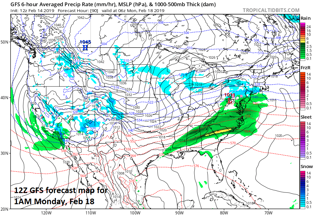
By Tuesday, there will lots of moisture gathering north of the Gulf of Mexico. It looks like low pressure will pull out of that part of the country and head towards a pretty cold air mass in the Northeast US. Snow could break out late Tuesday night or early Wednesday in the Mid-Atlantic region and then perhaps change to ice and rain – somewhat similar to the storm earlier this week. That system is still several days away and will have to be monitored closely in coming days.

Low pressure may pull out of the southern states next week and impact the Mid-Atlantic region by late Tuesday night or Wednesday; courtesy NOAA, tropicaltidbits.com
California Update
A powerful Pacific Ocean storm continues to slam California today bringing heavy coastal rains, damaging wind gusts and incredible amounts of snow to the Sierra Nevada Mountains. A persistent flow of air from the eastern Pacific Ocean continues to push very humid air into California and this is leading to torrential rain and widespread flooding. In addition, there is a growing concern for dangerous mudslides from days of rain in those areas affected by wildfires last fall. Rain is falling with this system as far south as San Diego and even as far south as Baja California. In addition to the rain, wind gusts can reach 60 mph in many areas and power outages are also a big concern along with the flooding.
Farther inland, tremendous amounts of snow have been piling up in higher elevation locations of the Sierra Nevada Mountains. Snowfall has more than made up from a big deficit in December with many mountain areas now running close to or above average for the season with more big winter storms to go. Mammoth Mountain is a lava dome complex west of the town of Mammoth Lakes, California in the Sierra Nevada Mountain range. It has just broken a record for seasonal snowfall at 446 inches which translates to a little more than 37 feet and there is much more snow accumulation on the way.
Meteorologist Paul Dorian
Perspecta, Inc.
perspectaweather.com
Video discussion: