
4:00 PM Saturday | ***Wintry mess from late tomorrow into early Monday…strong storm by the middle of the week with possible significant snow and ice***
Paul Dorian

Overview
Low pressure will head our way late Sunday and produce snow and ice north of the PA/MD border and a wintry mix to the south of the Mason-Dixon Line. Road conditions can become slick from late tomorrow into early Monday with small accumulations of snow and/or ice. By the middle of the week, we’ll have to deal with a stronger storm and this one could result in significant precipitation for the Mid-Atlantic region including accumulating snow, ice and rain.

Upcoming threats
A wave of low pressure will impact the Mid-Atlantic region on Sunday night and this one looks like it may result in snow and ice to the north of the PA/MD border and primarily a mix of rain, freezing rain and sleet to the south of there. Small snow and ice accumulations of a coating to an inch or two are possible across much of eastern Pennsylvania and New Jersey from later Sunday into early Monday and there can be a layer of ice generated to the south of the PA/MD border. Untreated road surfaces can become slick in all areas by tomorrow night and perhaps even lingering into the Monday AM commute. High pressure will then build into the Mid-Atlantic region during the early part of next week with seasonably cold conditions.
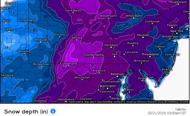
12Z Euro forecast map of snow depth between today and early Thursday morning; courtesy ECMWF, weather.us
By late Tuesday, strong high pressure will be forming to the north and northwest of the Mid-Atlantic region and there will be lots of moisture pushing northward from the Gulf of Mexico into the Tennessee Valley. By early Wednesday, snow is likely to break out in the DC metro region and then expand northeastward towards Philly and NYC for the mid-day and afternoon. By later Wednesday, milder air will advance northwestward along the east coast – at least into the upper part of the atmosphere – and this could result in a changeover to sleet and freezing rain and perhaps ultimately to plain rain. Significant accumulations of snow and ice, however, are certainly on the table in the late Tuesday night/Wednesday time frame along the DC-to-Philly-to-NYC corridor before any potential changeover to sleet, freezing rain and perhaps plain rain.
Meteorologist Paul Dorian
Perspecta, Inc.
perspectaweather.com